Statements
GEO Week 2023
- Home/
- Events/
- Geo Week 2023 /
- Statements
-
Armenia
In 2023, the first private space initiative took off with the Bazoomq foundation, becoming the first non-profit organization to receive a license for conducting space activities in Armenia. The Bazoomq foundation initiated the technology demonstration project “Hayasat” This project involved the Armenian team in testing and assembling Flatsat, programming and integrating flight modules, and developing a secondary payload.

Hayk Martirosyan
Founder of “Bazoomq” Space research lab, Armenia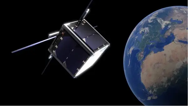
ML4GEO project (Project ID: 20TTCG-1E009), (2020-2023) state-funded project has launched on building capacities of the Center for Ecological-Noosphere Studies of the National Academy of Sciences of Armenia (CENS), the leading organization on GIS and remote sensing enabled environmental research in Armenia on innovative approaches for processing earth observation geospatial data in geoecological investigations. The project is funded by the State Committee of Sciences of the Ministry of Education, Science, Sport and Culture of Armenia. The core of the project is the implementation of a research program designed to develop Machine Learning models of RS data geoprocessing with the purpose of assessing spatial-temporal changes in atmospheric air temperatures in urban spaces associated with climate change.
Dr. Shushanik Asmaryan
GEO Principal of Armenia; Deputy Director for Science and Head of GIS and Remote Sensing department of CENS, The Principal Investigator of the Remote Sensing group in the SEVAMOD2 project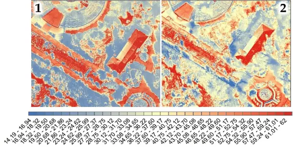
SEVAMOD2 project (Project ID 01DK20038) (2020-2023) funded by the Federal Ministry for Education and Research of Germany and the Ministry of Environment of the Republic of Armenia. Project is jointly conducted by the Department Lake Research of UFZ, (Germany), Scientific Center of Zoology and Hydroecology of the NAS RA (Armenia), CENS NAS RA (Armenia) and HMC of the Ministry of Environment of the Republic of Armenia, EOMAP Company (Germany). The project is aimed at building up science-based management instruments for Lake Sevan (Armenia) via investigating the water quality parameters of Lake Sevan, such as water surface temperature, chlorophyll-a, and Harmful Algae Bloom (HAB), using daily satellite images from the European Sentinel-3/2. This aimed to identify the blooming period of HAB in the lake based on remote sensing data.
Dr. Shushanik Asmaryan
GEO Principal of Armenia; Deputy Director for Science and Head of GIS and Remote Sensing department of CENS, The Principal Investigator of the Remote Sensing group in the SEVAMOD2 project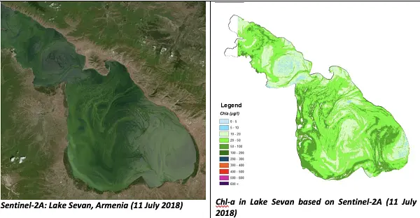
In 2023, Space Camp programme initiated successfully by the Ministry of High-Tech Industry of the Republic of Armenia, in cooperation with scientific institutions and private space research and remote sensing companies featured a series of lectures and practical training designed to introduce students aged 15 to 17 to the space Industry and science, emphasizing Earth observation data and technologies and their various applications.
Ararat Sahakyan
Head of Market Research Division Ministry of High-Tech Industry of the Republic of Armenia
In 2023, Armenian Geocosmos CJSC and Spanish Satlantis Microsats, S.L. continued their cooperation in establishing a mission control center and ground station in Armenia in the framework of Armsat-1 mission.
Ararat Sahakyan
Head of Market Research Division Ministry of High-Tech Industry of the Republic of Armenia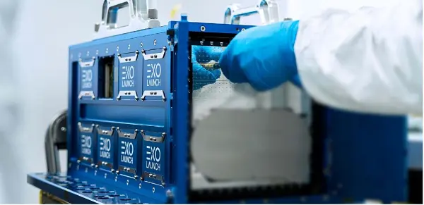
The Republic of Armenia places great significance on the development of its national Space and Earth Observation related capacities and science, with a special focus on Earth observation, which has been one of the most impactful and dynamically growing subsector in 2023.
Shushanik Asmaryan
GEO Principal of Armenia
-
Australia
At Geoscience Australia, we believe in the importance of providing free and open access to Earth observations enabling the Australian industry to innovate, support emerging needs and bring new capabilities across many government and industry sectors. Through our development of the open-source Open Data Cube, underpinned by Analysis Ready Data, Australia is proud to continue its membership of GEO and be part of the global effort to tackle Earth’s challenges.
Maree Wilson
Branch Head, Digital Earth Branch, Space Division, Geoscience Australia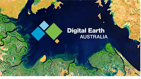
-
Cambodia
A new member since 2017, Cambodia has learned a lot about the advancement of the GEO products and the experiences by its member states. Cambodia GEO has started activities by collecting data for primary and secondary data relate to Disaster, Environment and Climate change. This result will be used for government to make the policy for disaster, environment impact and climate change existing data. The main vision of Cambodia GEO is willing to develop « Data Cube in Cambodia ». Cambodia GEO is hope that it will be improved step by step through data sharing from EO Data community. Cambodia became the 104th member of the Group on Earth Observation (GEO) in 2017. The main vision for Cambodia GEO is to develop Data Cube in Cambodia and the future for monitoring natural resources and man-cause disasters such as flood, drought, rain storm, typhoon, thunderstorm, land slide, and deforestation as a part of SDGs implementation. To response this vision, Cambodia has been set up the project by using limited budget from the Royal Government of Cambodia. The main activities of this project are collecting data for primary data in the field and secondary data from relevant ministries and government institution involvement. The Cambodia GEO will also use the satellite data sharing from GEO member countries combine with social economic data has collected from survey and government institution involvement. Due to rapid population growth which causes the increase of urbanization, some land has transformed from rice field to settlement and other land uses giving negative impacts to environment such as water pollution and poor sanitation. The survey has shown that the infrastructure has broken by flooding and the household who living in along the river has also affected by flooding. The rise river water has decreased gradually, raining fall is irregularly and the air temperature in Cambodia during dry season is significantly high approximately 34OC to 35OC in the past few years. The survey shows that this year the temperature fluctuates very much in both dry and wet seasons which is too cold in wet season and too hot in dry season and is considered as the cause by the global warming.
Meng Kimhor, Ph.D.
Deputy Director General, National Institute of Statistics, Ministry of Planning, Cambodia GEO PrincipalGEO has an excellent mission which is to introduce the advancement of the earth observation data which is extremely useful for monitoring natural disasters including flood, drought, landslide, earthquake, air pollution, etc. It helps developing Countries including those in the Lower Mekong Basin which covers Cambodia, Lao PDR, Thailand, and Vietnam and make it possible for them to manage natural resources as well as mitigate disaster risks through space observation data. Data Cube will be the data sharing hub and network for GEO Membership Countries to exchange and share their knowledge and technical experiences. The Mekong River Commission is pleased to be a good partnership with GEO in the near future for a better management and mitigation of the natural resources and natural disasters as a mean to contribute to the implementation of the SDGs.
Mr. Hour Ix
Regional Expert on Drought Management and Mitigation The Mekong River Commission Secretariat (MRCS) The Regional Flood and Drought Management Centre (RFDMC) -

Canada
Canada continues to strengthen its national GEO community and its contributions to address key global challenges, such as climate change, biodiversity loss, and pollution. As highlighted in Canada’s Satellite Earth Observation Strategy, we will continue to strive to enhance access to open data for all and foster domestic and international partnerships that recognize the importance of engaging and building capacity among Indigenous communities, women and gender minorities, and other traditionally marginalized peoples, as well as our youth, to ensure the use of EO to benefit our planet is inclusive, sustainable over time, and leveraged to its full potential.
David Harper
GEO Principal for Canada, and Director General, Meteorological Service of Canada, Environment and Climate Change Canada
It is necessarily through strong and broad partnerships that we can feed the ever-growing need for satellite data and inform global and local action on Earth. National and international multidisciplinary collaboration is the key to achieving success. The Canadian Space Agency is a key player in the implementation of the Canadian Satellite Earth Observation Strategy by proceeding with missions about Atmospheric sciences and wildfire management. On the international front, the Canadian Space Agency is looking forward to chairing the Committee on Earth Observation Satellites (CEOS) in 2024 and extend the use of EO into new areas and continue the CEOS-GEO collaboration.
Éric Laliberté
CEOS Principal for Canada and Associate Director General, Canadian Space Agency
GEO BON, is a network of over 2,800 members across 141 countries worldwide, advancing research and collaboration to support a Global Biodiversity Observation System. GEO BON’s global conference in Montreal convened its community Oct 10-13 2023 to exchange knowledge and demonstrate progress in the development of biodiversity observation networks, and open data portals and tools. These advancements facilitate the access of biodiversity data and the development of indicators for biodiversity conservation. GEO BON continues to provide monitoring science in support of the implementation of Kunming-Montreal global biodiversity framework of the UN Convention on Biological Diversity. (COPCBD decision 15/5)
Andrew Gonzalez
Professor McGill University, Liber Ero Chair in Biodiversity Conservation, co-chair of GEO BON, and Quebec Centre for Biodiversity Science Director
Agriculture and Agri-Food Canada (AAFC) contributes leadership to the GEO Global Agricultural Monitoring initiative (GEOGLAM) and the GEOGLAM Joint Experiment for Crop Assessment and Monitoring (JECAM) network through its work in EO-based mapping and monitoring of agricultural landscapes, particularly with respect to the use of synthetic aperture radar (SAR). AAFC’s international science and technology collaborations span the entire EO research-development-deployment continuum. This work has allowed AAFC to improve its operational EO-based agricultural monitoring systems and, in doing so, deliver valuable public-good data to Canadians. AAFC also continues to be an active member in the GEO Programme Board where it shares its experience and expertise and pursues potential synergies for further collaborative work.
Dr. Andrew M. Davidson
Associate Director - Research, Development and Technology, Agroclimate, Geomatics, Earth Observation & Agroecosystem Resilience, Science and Technology Branch, Agriculture and Agri-Food Canada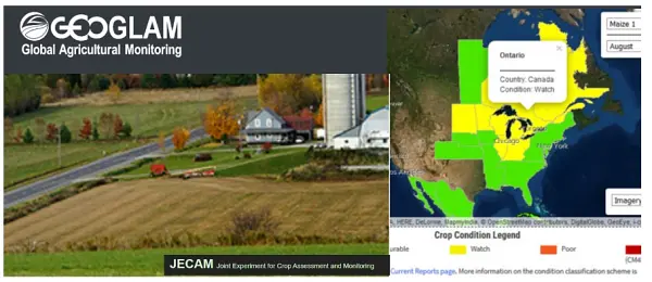
-
Caribbean Meteorological Organization
In support of GEO’s mission and the needs of our Members, the Caribbean Meteorological Organization initiated activities to increase access to Earth observations, including establishing a new node for real-time earth-system data exchange, training workshops, and creating a multi-disciplinary community of practice, which augmented national and regional capacity in the use of geospatial information technologies for monitoring hydrometeorological events and coastal ecosystems.
Dr Arlene Laing
Coordinating Director - Caribbean Meteorological Organization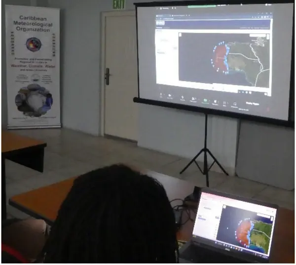
-
Centre for Environment and Development for the Arab Region and Europe
CEDARE is governed by a high-level Board of Trustees that includes environmental policy and decision-makers. CEDARE is committed to highlighting the great value that EO's data and services provide to member countries. The overall goal is to strengthen existing capacities to produce and share actions on climate change and disaster risk reduction. Recently, CEDARE is using EO for enhancing the In-situ Environmental Observations across Under-sampled Deserts, oil spill monitoring, identify potential fishing zones, and develop the first Solar Atlas of Egypt.
Omar Elbadawy
Regional Program Manager - CEDARE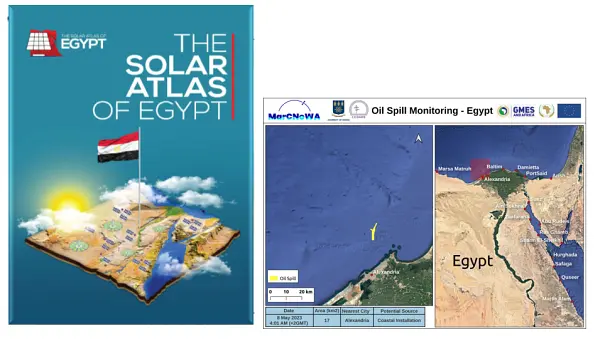
-

China
I believe that in the future, GEO will further leverage the advantages of inter-governmental and international organizations to promote the connectivity of Earth observation infrastructure, the smooth flow of spatial and geographic information elements, the harmonization of concepts and philosophies among countries with a value orientation of inclusiveness and mutual learning, and the heart-to-heart bond among the international general public, aiming at jointly boosting stronger, greener, and more sustainable future shared by all.
Dr. ZHANG Guangjun
GEO China Co-chair, Vice-minister of Science and Technology of China
From May 29 to 31, we successfully held the 6th AOGEO Workshop in Macau, China. Under the theme ‘Demand-driven Advancements in Earth Observation Technology and Application’, the Workshop attracted more than 80 offline participants from 18 countries and 6700 participants online among which heated discussions were delivered covering various region-specific topics including capacity building, youth’s participation in GEO, open data and open knowledge, etc. As the GEO co-chair representing AOGEO and developing countries, China will continue dedicating efforts into regional Earth observation advancement in pursuit of a balanced and mutual development to close digital and information gaps.
Dr. ZHAO Jing
Director General of GEO China Secretariat National Remote Sensing Center of China
GEO China initiated the Collaborative Network of Disaster Data Response (CDDR) in 2016 in response to the GEO’s call for global coordinated disaster risk reduction. By October, 2023, the CDDR mechanism has been triggered 47 times in total by global major disasters including earthquakes, volcano eruption, floods, tsunami, typhoon, wild fires, explosion, avalanche, among others in 33 countries. Satellite data, images, disaster analysis, rapid mapping and related services sourced from more than 30 public and commercial Chinese satellites were provided to affected countries for free. In the future, China welcomes contributions from more countries and institutions to CDDR, enabling countries with insufficient capacity in disaster risk reduction to benefit from Earth observations.
Dr. LIU Zhichun
Deputy Director General of GEO China Secretariat National Remote Sensing Center of China
Under the direction of GEO China Secretariat (NRSCC), targeting the GEO Engagement Priority of Resilient City and Human Settlement, GEO China Expert Working Group closely keeps pace with GEO’s advancement. Together with multi-disciplinary talents applying Earth observations, we are building an integrated space-air-ground monitoring system, leveraging the sensing intelligence for all in our cities and human settlement. We will continue transforming scientific research into applicable and accessible EO services and products to secure a sustainable and resilient future in support for the New Urban Agenda along with other global initiatives.
Prof. YUE Qingrui
President, National Science and Technology Institute of Urban Safety Development of China; Dean, Research Institute of Urbanization and Urban Safety, University of Science and Technology Beijing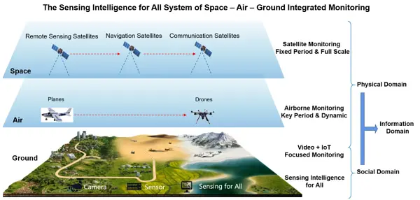
Based on long time-series Earth observation satellite data and socio-economic data, we have developed SDGs indicators and local dynamic monitoring and evaluation platform, aiming at analyzing transformation between SDGs indicators and geoinformation and calculating SDGs indicators to support dynamic and normalized monitoring. The application case of this platform was delivered in Deqing, China, and exhibited an 8-minute coverage of medical facilities. The case was also presented at the UN Summit on Sustainable Development Goals in Sept., 2023.
Prof. Chen Jun
Academic, the Chinese Academy of Engineering, National Geomatics Center of China, Ministry of Natural Rerourses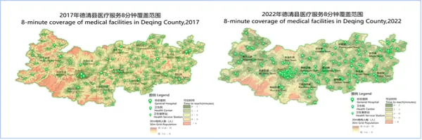
Initiated by National Remote Sensing Center of China in 2012, Global Ecosystem and Environment Observation Analysis Research Cooperation (GEOARC) has been consecutively releasing analytical reports and datasets for more than 10 years, covering a wide range of topics such as water, cities, climate change, natural disasters, crop, cryosphere and so on, in which EO tools are used to support decision making, capacity building and scientific research. So far, GEOARC has published 31 annual reports and 115 open access datasets in total.
Prof. LIU Qinhuo
Aerospace Information Research Institute, the Chinese Academy of Sciences (AIRCAS)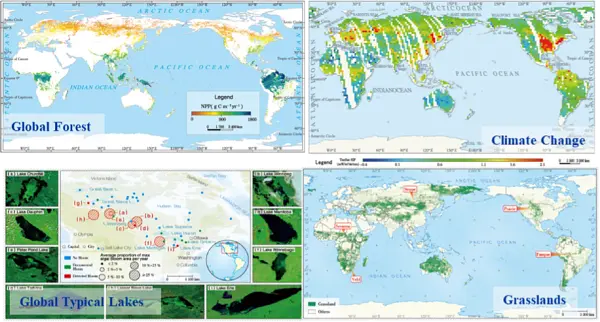
On February 6, 2023, Earthquakes occurred in southern Turkey within 10 hours, causing heavy casualties, serious damage to social and economic facilities in 11 provinces of Turkey and parts of Syria. UNOSAT has collaborated with Wuhan University for the disaster loss mapping. Night-time imagery from Chinese satellites and U.S. satellites were combined to track the electricity loss and recovery in the disaster-affected cities.
Prof. LI Xi
Wuhan University
-

Committee on Earth Observation Satellites
Space Technology for Better Environments, Economies, and Humanity
Pakorn Apaphant
Executive Director - Geo-Informatics and Space Technology Development Agency (GISTDA)
-
Committee on Space Research
Through the partnership between COSPAR and GEO, a commitment is being forged to facilitate the utilization of data in a manner that adheres to the principles of Findability, Accessibility, Interoperability, and Reusability (FAIR). Increasing availability and documentation of data is key for decision making and creating measurable impact within user communities. A rapid, reproducible, and repeatable process for consumption of data and publication resources is especially critical given present-day global challenges. COSPAR seeks to promote an accelerated framework for data use across GEO member organizations.
-
European Association of Remote Sensing Companies
The European Earth Observation private sector is committed to supporting the 2030 Agenda for Sustainable Development and the three global priority engagement areas of GEO. EARSC is convinced that the effective combination of governments, academia and private sector is fundamental to achieving these goals. EARSC’s involvement as a GEO Participating Organisation has resulted in a marked increase in the interest of European companies in GEO.
Emmanuel Pajot
Secretary General - EARSC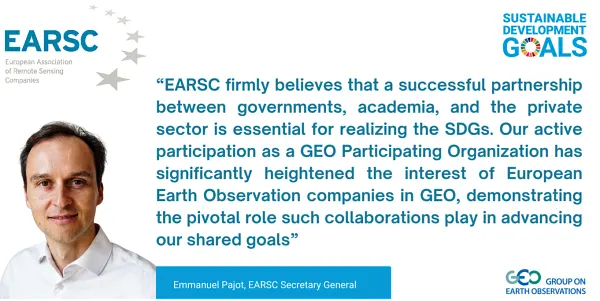
As EARSC Chair, I consider it very important to maintain a sustained dialogue with organizations such as GEO and therefore it is a great asset to have EARSC as single voice representing and putting forward the perspective of the European EO services industry.
Marc Tondriaux
Chair representing the Board of Directors - EARSC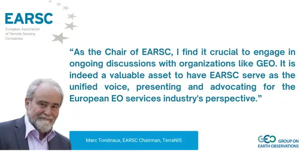
The EU Copernicus programme is a key asset contributing to GEO. Through its involvement in EuroGEO and within the EuroGEOSS showcases project, e-shape, EARSC is leading the user uptake, capacity building and liaison activities supporting the GEO Work programme. EARSC is supporting the engagement of the private sector in GEO working groups and recently contributed to the Mapping the Engagement of the 2020-2022 GEO Work Programme in Climate Action, Disaster Risk Reduction, and Capacity Development.
Mónica Miguel-Lago
Senior Project Officer - EARSC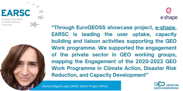
EARSC is committed to highlighting the significant value delivered by EO data and services to citizens, corporations and governments. EARSC actively stimulates the uptake of services based on satellite data, to bring the benefits of space to society.
EARSC secretariat
EARSC
-

European Centre for Medium-Range Weather Forecasts
From COVID-19 and urban heat island, to detection of air or water quality, the need for health and environment sectors to work together is growing. Collecting environmental data that are relevant for health, inspiring users like GEO and reaching out new communities are our main goals for the Copernicus Health Hub.
Dr Julie Letertre
Responsible for the Copernicus Health Hub - ECMWF
Energy communities and particularly the renewable sector, are key and very active users of the Copernicus products. The Copernicus Energy Hub is at its initial steps and will facilitate the full exploitation of the data and information. We are excited to further engage with existing and new users and to move forward additional Copernicus potentialities for the energy sector.
Dr Nube Gonzalez Reviriego
Responsible for the Copernicus Energy Hub - ECMWF
-
European Commission
The Group on Earth Observations (GEO) is working closely with Copernicus, the Earth observation component of the European Union (EU)’s Space Programme, as well as Horizon Europe, EU’s Research and Innovation Programme, to bring together global Earth observation and other data in support of Sustainable Development Goals, Climate Action, Disaster Risk Reduction and broader policy and decision making in a wide range of sectors. From the start, Copernicus was conceived, designed, and implemented as the EU contribution to GEO with similar free and open data policy principles. As an example, ‘maps without gaps’ developed by the Copernicus Climate Change Service (C3S) use a wealth of observations from those many data streams and allow tracking climate variability and change over time in a consistent way so as to support EU’s climate mitigation and adaptation strategies.
Mauro Facchini
Head of Earth Observation at the Directorate General for Defense Industry and Space, European Commission
In a data driven economy, earth observation data and services are a game changer and essential input in building sustainable Early Warning Systems for effective climate change adaptation and disaster risk reduction. The European Commission committed to support the strengthening of Africa Multi-Hazard Early Warning and Early Action System (AMEWHAS), ultimately contributing also to the GEO work programme priorities on Disaster Risk Reduction.
Carla Montesi
Director for Green Deal and Digital Agenda at the Directorate General for International Partnership
Earth Observation (EO) digital cloud infrastructures have emerged as easily accessible environments with the essential assets and processing tools required for analyzing data in a highly automated and scalable way. However, the current EO infrastructures and initiatives landscape is fragmented, with different levels of user onboarding and uptake success. The Joint Research Centre (JRC), the European Commission's science and knowledge service, is mapping the user’s requirements to existing EO infrastructures and services, with the goal of identifying existing overlaps and gaps. The JRC reviewed over 150 digital infrastructures and initiatives and categorized them according to the most prominent services. From a user-driven perspective, a series of requirements spanning from discoverability of available datasets, models, services, to transparency of pricing, from the problem of service sustainability to service redundancy, transparency of costs and technical specs, interoperability and accessibility, were investigated. The outcome is a preliminary phase for designing a user centric framework in evaluating EO digital infrastructures. To complement the work, also a series of advisory technological enablers are provided in order to alleviate user’s challenges and enhance interconnection amongst the services, thus facilitating the interoperability between platforms and fostering the discoverability of available services.
Albana KONA, PhD
T1 - Digital Economy, Directorate Digital Transformation and Data, Joint Research Centre European Commission
In support of the European Commission, the European Environment Agency (EEA) has been running a three-year project focused on improving the sharing and use of in situ Earth observation data in support of environment and climate policies. An important focus of this project lies in supporting the GEO Data Working Group (DWG), in particular its in-situ data activities. Under the co-leadership of EEA, the In Situ Subgroup of the DWG is engaging with GEO Work Programme activities, identifying common barriers to in-situ data sharing and use and proposing ways to address these barriers. We have developed a tool for the GEO community (G-reqs) that provides a methodology for the collection and management of in-situ data user requirements, and we are currently engaging GEO Work Programme activities to document their needs. We expect that these activities will be improve the availability and accessibility of in-situ data, in line with the In Situ Data Strategy for GEO. In the context of this project, the EEA is developing showcases on how openly available in situ datasets could be used to benefit climate adaptation policies and initiatives. For example, we developed a methodology making use of in situ data from city tree inventories to calculate indicators of Urban Biodiversity at the local level, automatising the tree species classification into native, invasive and toxic. This methodology will be made openly available, allowing other cities to import their own data and compute their version of this indicator, thus facilitating comparison across cities and over time (see above). We are also developing a methodology combining Earth Observation, statistical data and models of energy use at building level to derive a Building Energy Performance Indicator at district level.
Stefan JENSEN
Acting Head of Programme Data and Information Services European Environment Agency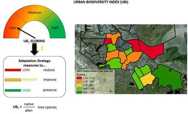
Earth Observation-based services are essential for tackling today’s major societal and environmental challenges. Space technologies are an indispensable tool in the fight against climate change, environmental degradation, and food insecurity. The European Commission and the African Union Commission are committed to working together to ensure that the GMES and Africa programme continues to be a reference in Africa for decision-makers and for a sustainable livelihood. This will not only be beneficial for the AfriGEO community, but it will surely contribute to the advancement of the GEO Work programme and its priorities.
Tidiane Ouattara
Space Science expert and GMES & Africa Program Coordinator
EIFFEL is an EU-funded Horizon 2020 project that aims to offer the EO-based community the ground-breaking capacity of exploiting existing GEOSS and external datasets and build upon prior knowledge, with minimal new data collection activities. The project, aiming to address the GEO Societal Benefit Areas (Water and Land Use Management, Sustainable Agriculture, Transport Management, Sustainable Urban Development, Disaster Resilience) will uptake five pilot applications representing different geographic areas and climate regions, namely: i) Pilot 1: Water & Land-Use Management Regional Scale & Cross-border I Netherlands, Germany, ii) Pilot 2: Sustainable Agriculture National scale I Lithuania, iii) Pilot 3: Infrastructure & Transport Management Regional Scale I Spain, iv) Pilot 4: Sustainable Urban Development Local Regional Scale I Greece, v) Pilot 5: Disaster Resilience > Drought, forest fire & pest risk assessment Regional | National Scale Ι Finland. Moreover, EIFFEL actively participating in the GEO Work Programme post-2019, encourages the stakeholders’ engagement and involvement in the project activities. It also serves as a portal where other projects and initiatives can contribute offering their data for climate change. EIFFEL project contributes to the new EuroGEO pilot applications to better understand Climate Change impacts, minimise the degradation of the Earth system, support accountability to long-term goals, inform climate services and decision making.
Dr. Angelos Amditis
Research and Development Director, Institute of Communication and Computer Systems (ICCS) I Coordinator of EIFFEL project
Citizen observatories to complement official measurements in the urban environment. The GREENGAGE project, funded by the European Commission’s Horizon Europe program, demonstrates the power of collaborative engagement: Focusing on mobility, air quality, and healthy living, citizens are encouraged to observe and actively participate in shaping their cities by mapping their urban environment to complement, validate, and enrich the information contained in authoritative data from public administrations and agencies. By involving citizens through Citizen Observatories and providing them with cutting-edge digital tools, GREENGAGE facilitates the co-creation of ground-level environmental monitoring solutions. This approach aligns seamlessly with GEO's mission of fostering cooperation between citizens, technical experts, and the scientific community to harness the full potential of climate-related products and services. GREENGAGE's dedication to innovative governance processes underscores its significant impact within the GEO community.
Jan Peters-Anders
Coordinator of GREENGAGE and Research Engineer at AIT – Austrian Institute of Technology GmbH, Vienna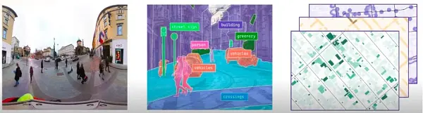
HARMONIA project supports the concept of Earth Intelligence: the HARMONIA Integrated Resilience Assessment Platform (IRAP) and Decision Support Systems (DSSs) are aimed at supporting decision-making and planning processes with knowledge derived by the integration of EO, in-situ and social data. The service provided is tailored for the needs of local administrations and takes into account the priorities and perceptions expressed by citizens in order to promote a collaborative approach for the improvement of urban resilience.
Prof. Julia Nerantzia TZORTZI
Associate Professor, Ph. D. Coordinator of Harmonia (harmonia-project.eu) Politecnico di MilanoThe TEMBO Africa project, supported by the European Commission’s Horizon Europe programme, develops services for Africa based on in situ data for flood early warning, hydropower dam reservoir management and agricultural germination insurance, starting in Kenya, Zambia and Ghana. TEMBO Africa also develops cost-effective new sensors for weather, water and climate applications in Africa. The income derived from the services will make it possible to make the weather, water and climate data of TEMBO Africa partner TAHMO open and freely available through GEOSS. TEMBO Africa supports the GEO in situ data working subgroup and is connected to the GEO Global Water Sustainability (GEOGLoWS) initiative.
Mark Noort
CEO HCP International, GEOS Liaison TEMBO Africa Project
-

European Plate Observing System
EPOS is the pan-European Research Infrastructure for solid Earth science. Our vision is to promote open science by ensuring open, free, and seamless access to multi-disciplinary solid Earth science data and products for all stakeholders. The launch of the EPOS Data Portal (https://www.epos-eu.org/dataportal) in April 2023 is not only a key milestone towards this overarching goal , but also a direct contribution to the implementation of the GEO vision of a coordinated, comprehensive and sustained Earth observation information and services informing decisions and actions for the benefit of humankind. The EPOS Data Portal is designed to help scientist achieving a better understanding of the physical and chemical processes governing natural phenomena of the Earth system, improving the knowledge to support solving problems, addressing and mitigation of natural hazards, and supporting evidence-based predictions of the future behavior of Earth systems.
Lilli Freda
Executive Director - EPOS ERIC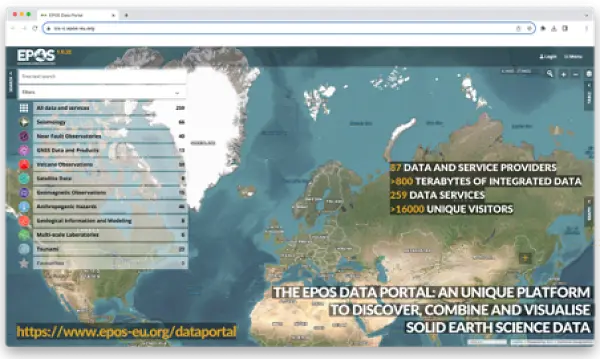
-
Future Earth
GEO BON with Future Earth Canada, and Sustainability in the Digital Age are conducting a survey of expert perceptions on the use of AI for biodiversity and ecosystem management to spark dialogue, identify knowledge gaps, and support the growth of a multi-sectoral community toward meeting the goals of the Global Biodiversity Framework. This will contribute to a white paper assessing the opportunities and challenges of AI for biodiversity measurement and reporting, and inform recommendations for effective corporate reporting.
Nilufar Sabet-Kassouf
Future Earth Canada
bioDISCOVERY is a strong supporter and implementer of GEO BON. The network collaborated with the GEO BON initiative in 2022 on a set of policy briefings and publications for CBD COP15. The two networks also held a joint workshop at the World Biodiversity Forum in June 2022, to discuss how to improve the flow of information from biodiversity monitoring and research to guide action. The workshop outcomes are published in Gonzalez et al, 2023, Nature Ecology & Evolution, ‘A global biodiversity observing system to unite monitoring and guide action’. A follow up workshop is planned for WBF 2024.
Cornelia Krug
Executive Director - bioDISCOVERY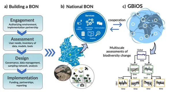
The Global Mountain Biodiversity Assessment (GMBA) engages with GEO through its contribution to GEO Mountains. It co-led the identification of a set of Essential Biodiversity Variables for assessing change in mountains together with the Mountain Research Initiative (MRI). This effort was initiated through a common workshop held at EGU in 2023. GMBA further supports the vision of GEO BON by promoting biodiversity observation efforts that contribute to the effective management of mountain biodiversity and mountain ecosystems worldwide.
Dr. Davnah Urbach
GMBA office, University of Bern, Switzerland
oneHEALTH Research in Future Earth’s oneHealth group centers on understanding how environmental, animal and human health are interconnected. To integrate the environmental aspect in our research we are using Earth observations of forest cover and land use mapping (ESA with 10 meter resolution, for example, or Landsat with 30 meter resolution) to understand how deforestation, land use change, or forest configuration (fragmentation, the amount of forest edges, etc), are affecting disease risk and human health. The figure below shows a map with forest core areas and forest edges created from the ESA mapping. This mapping is being used to create a Nipah Virus risk map for Bangladesh.
Paula R. Prist
Senior Scientist - EcoHealth Alliance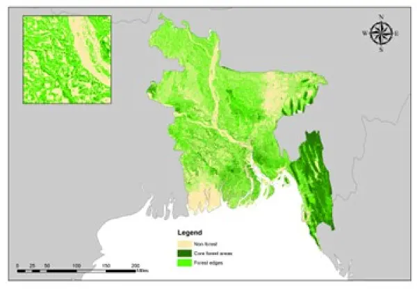
Water Futures / NEXUS Research in the water-energy-food nexus centers on the interconnections among these three vital components, requiring the collection of data in a synergistic manner for comprehensive nexus analysis. However, conventional research approaches have historically separated data collection into distinct ''spheres'' of water, energy, or food, resulting in spatial and temporal mismatches that limit their utility for nexus analysis. Earth observation systems offer a promising avenue for gathering data at spatial and temporal scales conducive to nexus studies. The NEXUS KAN is establishing its international project office in Hainan, China, and is keen to collaborate with GEO's initiatives such as GEOGlows and AquaWatch. Hydroelectric dams in the Mekong River Basin. Regular satellite observations of hydropower dams can capture their water storage for electricity generation and simultaneous distribution for crop irrigation and food production. By enabling long-term monitoring of water quantity and quality, these observations facilitate in-depth analyses of the dynamic linkages between water, energy, and food systems and the implications for local communities.
Jiaguo Qi
Michigan State University, USA
-
Germany
The Global Geodetic Centre of Excellence (GGCE) started to operate at the UN-Campus in Bonn/Germany in early 2023. The GGCE is going to provide important contributions to a worldwide geodetic infrastructure which is the reliable long-term foundation for applications like satellite navigation, space-borne Earth observation, and the monitoring of the UN Sustainable Development Goals. The Federal Agency for Cartography and Geodesy (BKG) is an international geodetic reference as operator of geodetic observatories on three continents and will support the work of the GGCE with its expertise. Germany – through BKG – contributes to the success of the GGCE by providing the necessary financial means to establish and start the GGCE.
Paul Becker
President, Federal Agency for Cartography and Geodesy (BKG)
Global urban development and health risks from climate change and air pollution can be assessed using the services ‘World Settlement Footprint’ and ‘Atmospheric Composition Monitoring’ as provided by DLR’s Earth Observation Center (https://geoservice.dlr.de/web/). To develop healthy and climate-resilient cities and assess the urban environment under current and future climate conditions and mobility scenarios these satellite products need to be combined with Urban Climate Models, like PALM-4U. As a contribution to EuroGEO, DLR developed services on “Urban Health Risks from Air Pollution” (https://www.alpendac.eu/eshape) and “Urban Climate Under Change. Given the demand for integrated assessments of multiple urban health risks, the development of user-driven services is essential. By following a rigorous co-design process, we look forward to contributing to GEO and strive for a continued uptake in science, planning and economy.
Thilo Erbertseder
Research Scientist and Project Manager, Earth Observation Center at DLR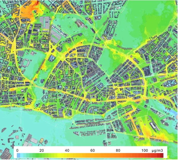
The Federal Institute for Geosciences and Natural Resources (BGR) carries out several development cooperation projects with African, Latin American and Asian partner countries. Many different, mainly freely available satellite data (e.g. Copernicus, Landsat), digital elevation models and geological survey data are used in these projects. The cooperation project with the Geological Survey of Bangladesh (GSB) “Geo-Information for Urban Planning and Adaptation to Climate Change” supporting the planning agencies in pilot cities data was successfully completed concerning the EO data aspect. The regional capacity enhancement for geothermal exploration in four countries of SICA (Central America Integration System) is currently being continued in the form of intensified training and application workshops.
Dr. Michaela Frei
Head of Unit “Remote Sensing”; Department “Geoscientific Information, Geoscientific Cooperation”; Federal Institute for Geosciences and Natural Resources.
-

Ghana
Through active participation in GEO, Ghana is paving the way towards realizing our national GEO vision, sharing the GEO document with key stakeholders, and contributing to a sustainable and data-driven future.
Dr. Joseph Bremang Tandoh
Director, Ghana Space Science and Technology Institute (GSSTI)
-

Greece
The SDG Decade of Action necessitates novel and systemic way of thinking. The Sustainable Development Solutions Network calls all hands on deck in this endeavor. Thus, we have established a working relationship with the Greek GEO Office in order to leverage the EO potential regarding the SDGs, beyond monitoring Indicators and into supporting Targets through their localization, an integral part of our agenda. We strongly advocate for the integration of EO and socio-economic data, to our delight one of the pillars of the new GEO Strategy, and are looking optimistically and deliberately ahead to co-design the concept of Earth Intelligence to the benefit of all.
Prof. Phoebe Kountouri
Athens University of Economics and Business Co-Chair of Sustainable Development Solutions Network Europe, Chair of the SDSN Global Climate Hub
Energy used for buildings construction and operation accounts for about 34% of the total global final energy consumption and contributes 37% to global GHG emissions. As a result, the buildings sector is at the center stage of international, EU and national efforts for improving energy efficiency and curbing emissions in order to fulfil the targets of the UN Paris Agreement on climate change. Bottom-up building stock models (BSM) utilize building typologies to handle the diversity of the thousands (or even millions) of existing buildings to quantify operational energy use and emissions, model their future evolution, and assess different renovation scenarios in order to transform buildings from being part of the problem to becoming part of the solution. However, accessing detailed data on the built environment remains a challenge. During a pilot study in Athens, GEO data proved an asset for providing up-to-date information about existing buildings with sufficient spatial analysis suitable for local planning, identifying building geometrical characteristics (e.g., building height, footprint), by complementing and updating census data from the Hellenic statistical authority (ELSTAT) using three different approaches (Tiers). The BSM utilized the Hellenic TABULA typology with energy and carbon intensities along with input data from the three Tiers to estimate the energy performance and GHG emissions and quantify savings under different deep renovation scenarios for municipal and regional building stocks. GEO data also facilitates our work on urban scale sustainability assessment and rating systems that are being developed to support municipalities, local authorities and other stakeholders to assess renovation and decarbonization plans of the built environment. The information can expedite the audit process of neighborhoods and cities, to collect data for quantifying sustainability criteria and key performance indicators like land use, open and green cover for soil sealing.
Dr. Constantinos A. Balaras
Research Director, National Observatory of Athens, Leader of the Group Energy Conservation, Fellow of ASHRAE, Former Vice President / Director & Regional Chair Region XIV – Europe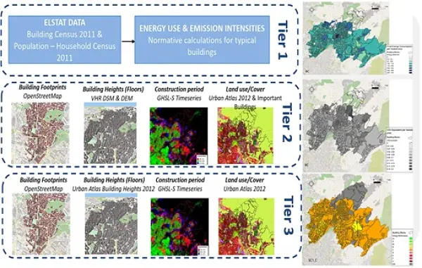
GEO and Earth Observation, being part of Big Data, has embraced AI as a tool to extract added value from the extraordinary proliferation of data coming from a wide array of EO platforms, from thousands of satellite images to IoT in situ sensors. Our company, LIBRA AI, in unison with the EO community, has worked towards exploiting another AI component, the Large Language Model. An out-of-the-box LLM through a vast EO corpus has been rendered Climate Change specific in order to, among others, enhance cognitive search. Could we leverage the pipeline and know-how to create a “GEO Large Language Model”?
Dr. Yannis Kopsinis
CEO and Co-Founder of LIBRA A.I. Technologies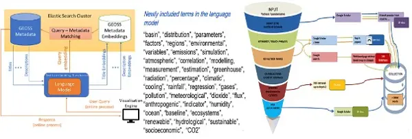
-

India
Government of India has opened the potential of the space sector for greater participation of Private Sector in space activities and Govt. space agency to focus on research and development and meet the requirements of national imperatives. Indian National Space Promotion and Authorization Centre (IN-SPACe) has been positioned for facilitating and regulating of space activities in India. In order to better understand the observational requirements of the user community and for optimal utilization of the space based observational asset, the Space Applications Management Systems (SAMS) mechanism has been established. Indian Space Policy 2023 has been announced where first of its kind satellite data liberalisation has been done. As per this, Indian Remote Sensing Satellite (IRS) data having 5m and higher spatial resolution are made available on ‘free and open’ basis to all. Any resolution of IRS data (produced using public funds) is made available “free of any charges” to Government agencies. All archived IRS satellite data & satellite derived thematic data is made available on ‘free and open basis’ to all sectors.
Dr. Prakash Chauhan
Director, National Remote Sensing Centre (NRSC) Indian Space Research Organisation (ISRO)
-

Integrated Carbon Observation System
With the KADI project, ICOS continues its cooperation with Africa, supports the activities of AfriGEO and strengthens the link to the in situ community. Through the co-design of climate services tailored to support African policy-makers, KADI will help define and implement the most relevant GHG measurements on the continent.
Dr. Theresia Bilola
Project manager - KADI (Knowledge and Climate Services from an African Observation and Data Research Infrastructure)
When I was asked, in 2022, to join the interim scientific committee of the China-based international science program Global Ecosystem Restoration and Carbon Neutrality (Global-ERCaN), it appeared to me like a major opportunity to engage with the Chinese colleagues on the fundamental link between ecosystem restoration and the world’s quest for carbon neutrality which is at the core of the activities of ICOS. After attending, in October 2023, the 1st Global-ERCaN Open Science Conference in Beijing and seeing the interest for my lecture entitled Towards common solutions in a multilateral world – The role of open scientific data in ecosystem research, I am convinced that ICOS has started a fruitful cooperation that will support the core objective of GEO: to advance the use of open earth observation data globally.
Dr. habil. Werner L. Kutsch
Director-General - ICOS ERIC
The strength of ICOS is to provide data from a network of high precision, highly-standardized measurement stations that monitor greenhouse gas concentrations and fluxes in the atmospheric, ecosystem and oceanic domains. With Greece and Ireland having joined ICOS in 2023, the ICOS network now counts more than 180 stations in 16 European countries. Not only the geographical coverage expands, but the scientific relevance of ICOS data increases, which improves the impact they have to support science-based decision-making.
Dr. Emmanuel Salmon
Head of Strategy & International Cooperation - ICOS ERIC
-
International Astronautical Federation
As the world’s leading and most diverse space advocacy organization with 523 members from 75 countries including space agencies, industry, research institution societies and associations worldwide, the IAF is proud to contribute to strengthening the advocacy and role to promote GEO’s key objectives including areas such as climate change and disaster management – to stakeholders around the world. One of the most significant contributions is the first-of-its-kind IAF Global Conference on Climate Change which was held in May 2023 in Oslo, Norway.
Dr. Christian Feichtinger
Executive Director - International Astronautical Federation (IAF)
-
International Institute for Geo-Information Science and Earth Observation
ITC supports GEO through a secondment to the GEO secretary on Capacity Development and Impact design. ITC staff members are actively involved in several GEO flagships and initiatives as participants in regional events, as members of the sub-groups or as co-chairs. Our Open Science officer coordinated the development of GEO’s Open Science/ Knowledge Statement. Beginning 2024, our online learning platform GEOVERSITY will be launched and accessible to the GEO community to share online tools, materials and training modules to the broader GEO community. Connection to and collaboration with GEO’s Knowledge Hub is foreseen.
Freek van der Meer
Dean - ITC
Being part of the global GEO network assures the sharing of knowledge and provides opportunities for collaboration and co-creation of tools, training/education materials and innovative technologies. In the context of ITC’s activities in geospatial technologies, remote sensing, planning & governance four profiling themes have been defined, which are closely aligned with GEO’s priorities. GeoAI Combines innovations in geospatial technologies with the rapid growth of methods in AI and big data, with the aim to responsibly translate complex and contextual data in useful information GeoHealth Understand the drivers behind spatial patterns in health and disease via a dynamic approach, and develop context-specific response strategies Resource security Aims at fair and sustainable use of our natural environment, and security and planning of environmental resources such as food, water, biodiversity, minerals, energy, and land, and their equitable availability for societies Disaster Resilience Integrating hazard assessment and disaster risk management into strategic planning and sustainable development.
Menno-Jan Kraak
Portfolioholder Capacity Development & Institutional Strengthening - ITC
ITC actively supports the GEO impact-oriented approach to strengthening the capacities of the GEO community to acquire, share, store, maintain and fully utilize Earth observation data and information in the decision-making process. The GEO Capacity Development Working Group provides support to the different working groups of the GEO Flagships, Initiatives and Regional GEO’s to develop strategies and operational guidelines to support the CD activities. Seminar series on best Capacity Development practices enhances the capacities of the GEO community to achieve sustainable impact. ITC currently supports Geo by developing a strategy to enhance the societal impact of the regional GEO’s, national networks, cluster activities, knowledge packages and GWP flagships and initiatives.
Joost Teuben
Senior Capacity Development and Impact Coordinator - GEO - ITC
-

Italy
Italy is strengthening the coordination amongst national experts involved in Earth Observation (EO) domains through the GEO-ITALY Group (www.geoitaly.org). The GEO-ITALY overarching goal is to reinforce the synergies amongst involved research and university institutions as well as the private EO sector in Italy, thus facilitating a broad range of capacity building and outreaching activities to stakeholders and policy makers both at national and international level. Members of GEO-ITALY are Representatives of the Ministry of Universities and Research (MUR) and the Ministry of Environment and Energy Security (MASE) and scientists, researchers and managers employed in several Institutes of the National Research Council of Italy, in the National Institute of Geophysics and Volcanology (INGV), in the Italian National Institute for Environmental Protection and Research (ISPRA), in many other public institutions in the Country, such as the Italian Space Agency (ASI) and the Euro-Mediterranean Centre on Climate Change (CMCC), as well as in private companies such as PLANETEK, Latitudo40, e-GEOS, just to cite a few.
Nicola Pirrone
GEO Principal of Italy, Research Director of the National Research Council of Italy
The Global Observing System for Mercury (GOS4M) is a GEO Flagship with aim to foster the sharing of monitoring data and modelling tools to support the implementation of the Minamata convention on Mercury at various geographical scales. GOS4M (www.gos4m.org) is aimed to federate existing networks of monitoring programmes and observing infrastructures – currently it provides a link to the Global Mercury Observation System (GMOS – www.gmos.eu) and other major existing regional networks. During the last year GOS4M developed the Knowledge Hub aimed to support the achievement of the objectives of international programmes and conventions related to mercury pollution which include UNEP, Minamata Convention on Mercury (MCM) Secretariat, UNECE-LRTAP and 2030 UN Agenda on SD. Special attention is paid to support all interested Parties in the implementation of the MCM. To this end global comparable monitoring data, validated models and policy interoperable tools are provided as part of the GOS4M Knowledge Hub designed to evaluate the relationship between cause and impact of mercury contamination, analyse cost-effective strategies aiming to reduce the mercury contamination at regional and global scale and co-design policy scenarios aiming to achieve the target of the MCM. The GOS4M KH provides also a tool to estimate the investment costs associated to a given mitigation strategy as well as the possibility to evaluate the risk for human health associated to major exposure patterns of mercury contaminated environments and food. GOS4M is also contributing to the GEO Knowledge Hub.
Sergio Cinnirella, Francesco De Simone, Ian M. Hedgecock
CNR - Institute of Atmospheric Pollution Research
Italy is continuing its activity aiming to improve discovery and access to data, information and knowledge and to support and further develop the GEOSS Platform as an open and public global infrastructure for data sharing and knowledge generation. Italy continues operating and advancing the GEO Discovery and Access Broker (GEO DAB) framework as one of the key components of the GEOSS Platform. Italy carries out activities for knowledge generation and management developing the Virtual Earth Laboratory (VLab), a knowledge platform for model sharing and running in multicloud environments. Italy is co-chair of the GEOSS Platform Operation Team (GPOT) and member of the GEO Infrastructure Development Task Team (GIDTT). It also participates to the activity of the GEO Data Working Group and its sub-groups. For the advancement and utilization of the GEOSS Platform, collaborations are ongoing with ESA, EC-JRC, USA (USGS), Germany (DWD), Switzerland (University of Geneva), China (Ministry of Science and Technology), Chile (Ministerio de Bienes Nacionales).
Paolo Mazzetti
Head of the Florence Division CNR - Institute of Atmospheric Pollution Research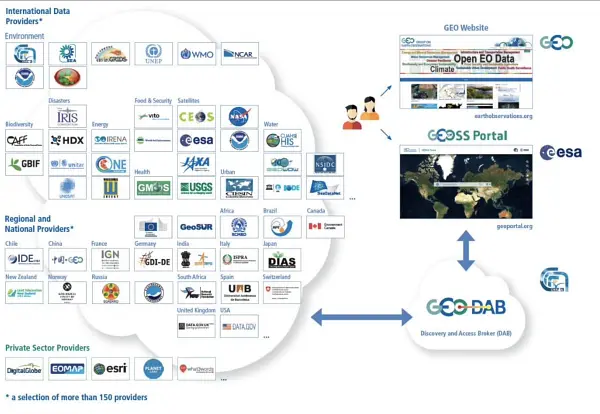
The Italian Space Agency (ASI) actively supports GEO Initiatives related to Disasters Risk Reduction like GEO-GSNL. ASI regularly provides thousands products from its national asssets (mainly COSMO- SlyMed, but also PRISMA and SAOCOM over ASI Area of Interest) to all the 13 Supersites and Natural laboratories all over the world and to pilot projects whose purpose is to demonstrate the value of earth observation data for Disaster Risk Reduction and to build regional capacity in this sector.
Giovanni Rum & Simona Zoffoli
Italian Space Agency (ASI)
Italy, through the INGV, coordinates and supports with important in-kind resource, the GEO- Geohazard Supersites and Natural Laboratories initiative (GEO-GSNL), established in 2010 under the Disaster SBA. GSNL is a network of 11 Supersites where a large community of scientists works to generate products for science-based decision making in Disaster Risk Management. GSNL is supported by the CEOS space agencies with satellite imagery and by a number of local monitoring agencies with in situ data. Supersite scientists openly share their in-situ and satellite data, promoting an Open Science approach and focusing on the sharing of scientific knowledge, capacity development, and technological innovation to increase the societal benefit geohazard science. All the Supersite coordinators are authoritative actors in the national frameworks for disaster prevention and response, and as such they constantly deliver hazard information generated for the Supersite, to the national decision makers, ensuring rapid and direct societal benefit of scientific findings. The Italian Space Agency (ASI) also supports GEO-GSNL, providing, on a continuous basis, over 2500 COSMO-SkyMed products per year that are key for achieving the GSNL objectives.
Stefano Salvi
National Institute of Geophysics and Volcanology - INGV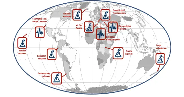
The Italian Space Agency (ASI) has launched on 22 March 2019 the PRISMA satellite carrying an hyperspectral sensor with a Ground Sampling Distance (GSD) of 30 m and covering the wavelength range from 400 nm to 2500 nm, with 10 nm spectral sampling. The launch was successful and the in-orbit commissioning has been completed, allowing PRISMA data to be accessible since May 2020 through the dedicated portal https://prisma.asi.it/. Data policy is based on a quasi-open and free access, with limitations on products per user quantities and on priorities for acquisition requests conflicts solving, to cope with the operational capabilities of the mission. Data policy allows commercial exploitation of value added product/services still delivering free of charge but forbids PRISMA original data redistribution. PRISMA catalog is now visible through GEOSS.
Giovanni Rum & Ettore Lopinto
Italian Space Agency (ASI)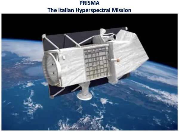
The Italian National Copernicus User Forum reflects the procedure of the Copernicus User Forum. It is composed of representatives of user communities belonging to public institutions, public and private research bodies, industries and enterprises, covering all the Copernicus domains. Each User Community representative participating in the activities has to stimulate the community that represents, from central to local level, by promoting the use of Copernicus services and products and to link existing national EO initiatives.
Andrea Taramelli
Deputy Delegate to the Copernicus Committee
Another Italian contribution to GEOSS, namely to AfriGEOSS, is represented by the EC Project PanAfGeo (Phase II) PanAfGeo - Pan-African Support to the EuroGeoSurveys-Organisation of African Geological Surveys (EGS-OAGS Partnership), co-funded by DG-DEVCO, is a project which supports the training of geoscientific staff from African Geological Surveys through the development of an innovative training programme. The project aims to increase African-owned geological knowledge and skills for sustainable mineral exploitation and related infrastructures, and natural disaster prevention and mitigation. Specifically, PanAfGeo enhances the capacity and role of African national Geological Surveys; ● Contributing to mineral resource assessments by national Geological Surveys in Africa; ● Increasing the activity of national Geological Surveys in regional mapping and exploration to upgrade their geoscientific information base and mineral inventories; ● Strengthening the level of geological knowledge and skills in national Geological Surveys through training; ● Strengthening OAGS’ potential to meet the needs of the African continent. Capacity building is addressed to over 1,200 trainees (mostly African geologists) with the organization of 49 short- and medium-term trainings in several African countries focused on wide range of geosciences topics such as satellite imagery analysis, geological mapping through GIS techniques, geo- hazards geochemistry and analytical chemistry, economic geology, mineral exploration. ISPRA is currently involved in PanAfGeo in WP-D New Frontiers in Geosciences (Geoheritage and Geothermal energy)and WP-E Geohazards and Environmental Management of Mines in cooperation with LTG (leader), Council for Geosciences-South Africa (co-leader), PGI, GeoZS in the organization of 6 technical training sessions in several African countries. More details of th project in: https:// panafgeo.eurogeosurveys.org
Giuseppe Delmonaco
Geological Survey of Italy, Italian Institute for Environmental Protection and Research (ISPRA)
Italy is part of the EuroGEOSec project consortium, which is aimed to support the EuroGEO vision and to prepare the transition of the EuroGEO initiative into a sustainable endeavor, by setting-up a EuroGEO secretariat. The overarching goal of the EuroGEOSec project is to support the coordination of the EuroGEO initiative and develop a sustainability plan guiding its long-term operation. This will be achieved by establishing the EuroGEO Secretariat with the mission to (i) strengthen GEO-related coordination mechanisms at European and national levels, (ii) support increased innovation, space application development and reinforcement of the European space data ecosystem concept; (iii) foster international cooperation to help stimulate the market and promote European technology and services; (iv) contribute to the European Green Deal objectives and the European strategy for data (EU Data Spaces) by further deploying and exploiting the use of EO towards a strengthened Global Earth Observation System of Systems (GEOSS).
Nicola Pirrone and Sergio Cinnirella
CNR - Institute of Atmospheric Pollution ResearchItaly is participating to the construction of the EIRENE RI (Research Infrastructure for EnvIRonmental Exposure assessmeNt in Europe), an ESFRI (European Strategy Forum on Research Infrastructures) infrastructure, which fills the gap in the European infrastructural landscape and pioneers the first EU infrastructure on human exposome (environmental determinants of health). A starting point in the roadmap is the EIRENE PPP project that aims to prepare the implementation of EIRENE RI as a consolidated European research infrastructure enabling the development of advanced technologies and complementary services on the characterization of complex environmental exposures and their impact on the European population. This will promote European excellence in Environmental & Health research by providing European researchers with transnational and/or virtual access to harmonized capacities, unique services, and comprehensive data addressing the current and future needs of public authorities. The initiative will foster the GEO Health CoP.
Nicola Pirrone, Francesca Sprovieri, Sergio Cinnirella, Ian M. Hedgecock, Teresa Sprovieri, Virginia Andreoli, Carmine Ungaro
CNR - Institute of Atmospheric Pollution Research
Italy coordinates the LIFE NewLife4Drylands project (LIFE PRE/IT/000007; https://www.newlife4drylands.eu). It aims at the definition of a protocol for the use of Earth Observation to assess the effectiveness of Nature-Based-Solutions (NBS) for the restoration of degraded and desertified areas. NewLife4Drylands is coordinated by CNR (Institute of Atmospheric Pollution Research) and includes partners from Italy (CNR-Institute of Bioeconomy, ISPRA, University of Rome 'La Sapienza'), Greece (Hellenic Society for the Protection of Nature, University of Crete) and Spain (CREAF). Six case studies in Greece (Nestos River, Mt. Asterousia), Italy (Palo Laziale, Alta Murgia) and Spain (El Bruc, Tifaracas) will guide the design of the r protocol design. The protocol will consist of methodologies and best practices replicable and reusable on different contexts to support effective land management policies. The NewLife4Drylands protocol advances the use of remote-sensing and in-situ Earth Observation collected from disparate sources including GEOSS, as a resource for decision-making in land management applications. The protocol will be disseminated and exploited at national, European and global level including EuroGEO and GEO.
Paolo Mazzetti
NewLife4Drylands Project Coordinator CNR - Institute of Atmospheric Pollution Research
Italy is supporting the GEO and UN-Habitat 'Earth Observation Toolkit for Sustainable Cities and Human Settlements' Programme. The Programme participates in the EO4SDG Initiative and aims at developing a customizable and continually updated toolkit on the integration of Earth Observation and geospatial information into the urban monitoring and reporting processes on SDG targets and indicators based on inputs from UN Member States and cities. The CNR-IIA indicator estimation approach consists of deriving and updating, from Earth Observation data, some essential variables for the urban ecosystem: the spatial distribution and density of urban population and settlement maps. By integrating these essential variables with other domain-specific information i.e., the particle pollutant maps, specific urban resilience indicators and sub-indicators can be quantified. The case study focuses on updating the distribution map of the migrant population regularly residing in Bari and neighbouring municipalities to monitor progress on the inclusiveness and sustainable urbanization targets of the SDG 11 of the UN 2030 Agenda.
Mariella Aquilino
CNR - Institute of Atmospheric Pollution Research
e-GEOS, an ASI (20%) / Telespazio (80%) company, , is a Global Leader in providing high technologic and innovative geoinformation services and platforms based on Artificial Intelligence and cloud technology with digital, fast and customized access covering all fields of the Geo-Spatial Information business. CLEOS, e-GEOS latest launch, is the Information cloud platform to unlock geoinformation value in AI-powered applications accessible through an enhanced user experience offering a direct market place access to customized products. e-GEOS offers a unique portfolio of application services, from data acquisition to the generation of analytics reports, also thanks to its radar capabilities and to the fast access to the superior monitoring capabilities of the COSMO-SkyMed constellation of first and second generation. e-GEOS has acquired also a leading position within the European Copernicus Program. e-GEOS application platforms include experienced and solid services for environmental protection, rush mapping in support to natural disaster management, specialized products for defense and intelligence, oil spill and ship detection, maritime surveillance and security, assets and critical infrastructures monitoring, landslides and ground subsidence analysis, thematic mapping for agriculture and forestry, climate change phenomena monitoring.
Fabio Volpe
Senior Scientist, e-GEOS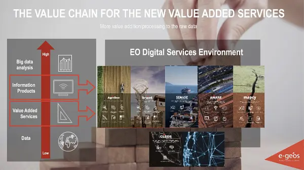
A further contribution of Italy to the many GEOSS Ecosystems tasks is offered by the GEO ECO (GEO Global Ecosystem) Community Activity and Action Group, co-lead by CNR. GEO ECO builds up and extends the approach used in the European Horizon 2020 ECOPOTENTIAL project, led by CNR, and from a few other initiatives, to other protected areas in Europe and in other continents. GEO ECO aims to use available Earth Observation data, research results and tools on a global scale for enhancing knowledge on natural ecosystems, identifying protected areas (PAs) of international relevance as focus areas for its activities, as they are aimed to preserve natural ecosystems, and thus have a high intrinsic value for human societies. In Italy, a key PA will be the Gran Paradiso and the Alta Murgia National Parks, also involved in ECOPOTENTIAL, the former H2020 project on Earth Observation data for ecosystems in protected areas supporting GEO (2015-2019). The detection and modelling of the state and development of natural ecosystems in PAs is a priority for the monitoring the advancement of the SDG 14 and 15. It also extends its analysis to unprotected areas. GEO ECO is adopting the view of ecosystems as 'one physical system' with their environment, characterized by strong geosphere-biosphere-anthroposphere interactions across multiple space and time scales.
Antonello Provenzale
Director, CNR - Institute of Geoscience and Earth Resources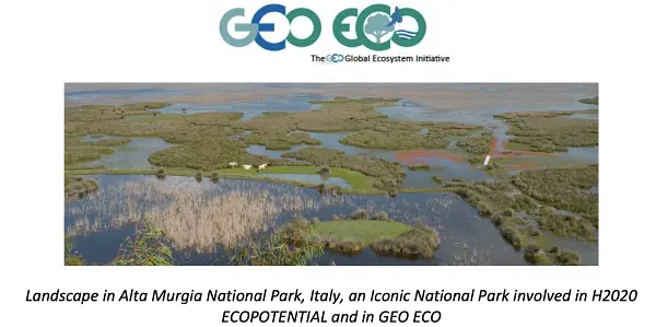
Planetek Italia is an Italian Benefit Company established in 1994, which employs 100+ women and men, passionate and skilled in Geoinformatics, Space solutions, and Earth science. Planetek provides solutions to exploit the value of geospatial data through all phases of data life cycle from acquisition, storage, management up to analysis and sharing. The company operates in many application areas ranging from environmental and land monitoring to open-government and smart cities, and including defence and security, as well as Space exploration and EO satellite missions. Among its main activity areas, the development of software for the satellite on-board data and image processing leads to the creation of a new business model called SpaceEdgeTM. SpaceEdgeTM is a new concept of satellite as-a-service powered by an Artificial Intelligence (AI) enhanced processing framework embarked on satellites, which makes available in-orbit payloads, resources, and services on-demand: services include EO data acquisition, processing, actionable information extraction, downlink, and distribution. Information detected in Space is then transferred back to the Ground as notifications and alerts or directly exploited on-board in autonomous decision workflows. Useless data and information non-relevant to the application’s workflow can be discarded, saving memory, bandwidth and thus increasing the efficiency and quality of automated pipelines too. The fields of application of on-board processing to reduce information latency are numerous, and will address GEO's priority engagement areas including the United Nations 2030 Agenda for Sustainable Development, the Paris Agreement, and the Sendai Framework for Disaster Risk Reduction.
Giovanni Sylos Labini
CEO, Planetek Italia s.r.l.
Latitudo 40 is a startup founded by four deep tech and space experts in 2017, which now employs a team of more than 15 people, with a predominance of Data Science experts for the development of new algorithms based on AI/ML and generative AI applied to the analysis and understanding of multi-spectral and hyperspectral satellite imagery. Latitudo 40, to make the most of the value of geospatial data, has invested in the development of a cloud-based platform to be used in SaaS mode for the analysis and monitoring of urban environments, with particular reference to the issue of planning sustainable and resilient cities of the future, identifying the main risks for the population and infrastructures (urban heat islands, urban heat risks, floods) and creating a map of intervention priorities for public decision-makers and urban planners, indicating possible mitigation actions using Nature Base Solutions. In addition, Latitudo 40 has developed a dataspace from space to foster the adoption of Geospatial solutions. In this space, system integrators and developers can find always-available datasets to understand urban risks better and create new applications in city monitoring, precision agriculture and infrastructure monitoring. EarthDataPlace makes spatial datasets available to everyone easily, quickly and inexpensively. Latitudo 40 supports the market with a vision of 'learning from the past, monitoring the present and designing the sustainable place of the future', and to pursue this strategy, it has launched its Place Simulator. This environmental scenario simulator takes as 'input' the different options for modifying the environmental scenario (changes in land cover/land use, new trees or green areas, etc.). It generates as 'output' synthetic satellite images obtained with Generative AI to assess the impact of the different scenarios and identify the best solution for the environment. The application areas of Latitudo 40 solutions provide a better and more detailed understanding of the variables that affect our environment and predominantly impact GEO's priority areas of endeavor, including the UN 2030 Agenda for Sustainable Development, the Paris Agreement and the Sendai Framework for Disaster Risk Reduction.
Gaetano Volpe
CEO, Latitudo 40
-

Japan
The Global Mangrove Watch is a multi-collaboration project that demonstrates the usefulness of Earth observation data –including L-band Synthetic Aperture Radar provided by JAXA – for mapping of globally significant ecosystem types. It provides public open, geospatially explicit data of global mangrove extent and annual changes relevant to international reporting frameworks such as the UNFCCC Paris Agreement, the UN Sustainable Development Goals, the Global Biodiversity Framework, and the Ramsar Convention.
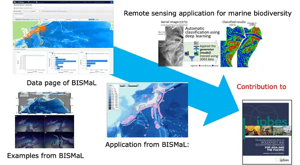
The Biological Information System for Marine Life (BISMaL), which has been developed by the Japan Agency for Marine Earth Science and Technology (JAMSTEC), has published 59 datasets (total 3.8 million biological observations) from scientific researches conducted by JAMSTEC, universities, research institutes and citizen science, in accordance with the FAIR (Findable, Accessible, Interoperable, Reusable) data principle. Integrated into the Ocean Biographic Information System (OBIS), it plays a key role as the primary information source in the Northwest Pacific region, and has been used in the Asia Pacific Marine Biodiversity Observation Network (AP-MBON) and contributed to the Intergovernmental Science-Policy Platform on Biology and Ecosystem Services (IPBES).
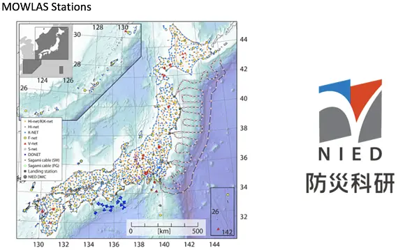
National Research Institute for Earth Science and Disaster Resilience (NIED) has an integrated observation network, The Monitoring of Waves on Land and Seafloor (MOWLAS), which consists of 2,100 stations to provide comprehensive, accurate, and rapid observation and monitoring of earthquake, tsunami, and volcano activity throughout Japan and its offshore areas. The application of real-time observations and processing of MOWLAS data has contributed to disaster mitigation through its earthquake early warning and tsunami warning.
-

Korea, Republic of
-
Mexico
Digital Earth Americas is an initiative that aims to bring together users from the Americas region to create an open and operational experience in countries for the analysis, use, and management of data to develop evidence-based public policies for decision-making. We are working to strengthen geospatial capabilities in the Caribbean. To this end, 8 webinars were scheduled, which began in April and will conclude next November. The project 'Strengthening Geospatial Capacities in the Caribbean' is currently underway and will contribute to the development of spatial sciences and geospatial technology applications in this region.
Paloma Merodio
Vice-President, INEGI
It has been relevant to be part of the World Water project, funded by the ESA, which aims to demonstrate how global EO data can be used to systematically and accurately measure inland surface water resources. This alliance allowed us to carry out the 'Seminar and technical training workshop on using EO for monitoring surface water dynamics' in Mexico City, with the participation of representatives of the State Units of the National Subsystem of Geographic Information, Environment, Land and Urban Planning.
Andrea Ramírez Santiago
Deputy Director of Geographical and Environmental Information Assessment INEGI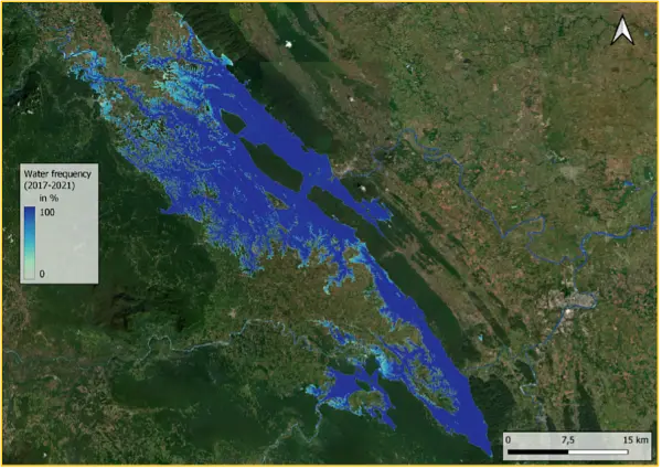
The Mexican Space Agency (AEM) and the National Natural Protected Areas Commission (CONANP) carried out the project “Vessels Monitoring of Fishing for the Control of Protected Natural Areas”, which was financed by the ESA. This project was implemented in Islas Marietas National Park, Isla Isabel National Park and the Islas Marías Biosphere Reserve. The system provides data and detailed information to the CONANP and allows monitoring of the activities carried out by ships, tourist boat operators and fishermen in the ANPs, and therefore, contributes to the protection of maritime ecosystems.
Prof. Rosa Ma. Ramírez de Arellano y Haro and Mr. Jesús Roberto Romero Ruiz
General Coordinator of International Affairs and Space Security Matters; Deputy Director of International Affairs at the Mexican Space Agency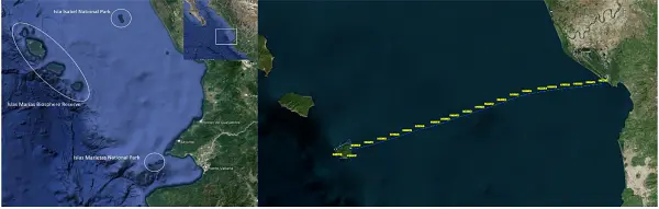
The Digital Image Processing Laboratory provides services to government and private institutions, both national and international. Generates products with high added value from satellite images, as well as advisory and training services. Free images of the satellites LANDSAT, SENTINEL, MODIS, GOES. Commercial images of the GEOSAT and GEOEYE satellites.
Dr. Adan Salazar Garibay
General Coordinator of Scientific Research and Space Technological Development at the Mexican Space Agency (AEM)
Mexico is an active member of AmeriGEO. In the organization of the annual events, we promote innovative sessions and side events related to the integration of statistical and geospatial data, as well as the use of spatial data infrastructure. During the last AmeriGEO week 2023 we organized a side event related to the use of artificial intelligence-based methods to map and characterize slums from Earth observation. Inter-institutional coordination mechanisms will allow us to develop regional projects to advance together in the use of Earth observations towards sustainable development in the region.
Jesarela López
Advisor in the Governing Board INEGI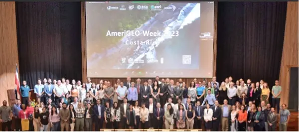
-

Netherlands
The Netherlands actively stimulates the development and use of services based on satellite data, to bring the benefits of space to society, science and economy.
Harm van de Wetering
Director, GEO Principal for the Netherlands - Netherlands Space Office (NSO)
The TROPOMI satellite instrument provides timely images of air quality and climate parameters for every place of the Earth. Already six years, with TROPOMI we can see which policy measures are effective for improving the air quality. TROPOMI has also been very successful in tracing methane emissions from oil and gas industry, urban hotspots (garbage dumps) and landfills.
Pepijn Veefkind
Principal Scientist,TROPOMI, Royal Netherlands Meteorological Institute (KNMI)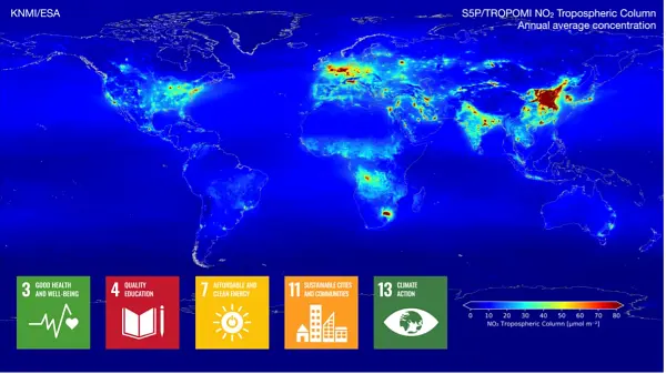
Over 4.5 million smallholder farmers in Africa and Asia have benefitted from products and services based on open and free satellite data in the Geodata for Agriculture and Water (G4AW) programme. Geodata-based services assist farmers and pastoralists in increasing their productivity and adapting to climate change. The successes, challenges and lessons learned of the 25 initiatives of G4AW are shared on the G4AW website. G4AW services are also introduced in new countries.
Wilma van Esch
Department of Inclusive Green Growth Ministry of Foreign Affairs, the Netherlands
We can turn the tide if we take fast, decisive action. The world needs to adapt to what is coming and do everything possible to immediately reduce emissions. Availability and accessibility of reliable data is crucial in this endeavor. Earth observation plays an important role. It increases our understanding of the consequences of climate change, and can thereby be a powerful tool for policymakers across the world.
Jaime de Bourbon de Parme
Climate Envoy, Kingdom of the Netherlands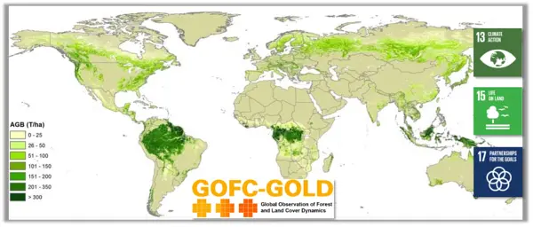
An increasing number of countries does not have enough water to grow food for their growing population. More crop per drop is needed. This is why the Netherlands supports the FAO WaPOR project that has the aim to improve land and water productivity in the face of climate change. Since October 6 2023 FAO WaPOR data are available at a global scale.
Aart van der Horst
Department of Inclusive Green Growth, Ministry of Foreign Affairs, the Netherlands
Dutch companies and institutions develop new innovative solutions using satellite data that contribute to the provision of information to facilitate climate adaptation and mitigation.
Kathelijne Beenen
Advisor Satellite Applications, Netherlands Space Office (NSO)
The Dutch initiated the Water, Peace and Security initiative - a broad coalition of international partners coordinated by IHE Delft Institute for Water Education - designed innovative tools and services identifying water-related security risks to help mobilize stakeholders, build capacity and facilitate action. Understand - mobilize - learn - facilitate - act!
Henk Ovink
Former Special Envoy for International Water Affairs, Kingdom of the Netherlands
Geodata are used by the Verified Sourcing Areas (VSA) of the Sustainable Trade Initiative (IDH) and partners to verify outcomes at landscape level, such as deforestation rates, included in Produce, Protect, Include compacts. Doing this, spatial data are used by local stakeholders, including government and private sector, driving sustainable production and international partners, like retailers and brands, for sustainable sourcing.
Omer van Renterghem
Department of Inclusive Green Growth, Ministry of Foreign Affairs, the Netherlands
Rabobank launched an agroforestry initiative aimed at sequestering CO2 while enhancing smallholder farmer practices in developing countries. This online platform connects large corporates looking to offset their unavoidable emissions with smallholder farmers who are sequestering carbon through agroforestry. The initiative also helps farmers improve their business model by transforming monoculture farming into future-proof agriculture.
Jelmer van de Mortel
Innovation lead Wholesale and Rural | Head of Acorn - Rabobank
We are here to identify and understand vulnerability – and to convert it into resilience by developing, applying and sharing geospatial impact-driven solutions We educate our students to be professionals, capable of acquiring knowledge and translating this into practical applications for solving real-world problems.
Prof. dr. Freek van der Meer
Dean of Faculty, ITC, University of Twente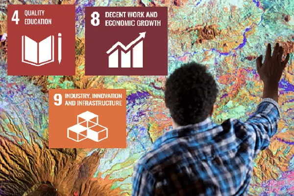
Our Action Research on Citizen Science helps GEO achieve impact related to sustainable development, elevating the value of citizen science communities and data from local to global scales.
Dr. Uta Wehn
IHE Delft Institute for Water Education
-

Open Geospatial Consortium
-
Russian Federation
Due to participation in such international associations as the Group on Earth Observations there are new opportunities for 'Roscosmos' in aiding states affected by natural disasters, emergencies and climate change by providing those in need with satellite data from Russian Earth remote sensing system.
Mikhail Khaylov
Deputy General Director, Roscosmos
-

Secretariat of the United Nations Convention to Combat Desertification
Governments have reported that, between 2015 and 2019, the world has been losing at least 100 million hectares of healthy and productive land every year, affecting billions of people. We must urgently stop further land degradation and restore at least 1 billion hectares to bring the land back in balance by 2030. The national assessments conducted by governments on the state of the world’s land would not have been possible without Earth Observation which allows us to systematically take the pulse of the planet and tell the world about the worsening global land degradation crisis.
Ibrahim Thiaw
Executive Secretary - United Nations Convention to Combat Desertification (UNCCD)
UNCCD recognizes that, in moving from a GEO initiative to a flagship, GEO LDN has galvanized the entire Earth Observation community around a central goal – to help all countries of the world reach land degradation neutrality by 2030 through coordinated observations, technologies and tools underpinned by agreed international standards. The mantra goes: “You can’t manage what you can’t measure” – and the GEO LDN flagship, has been central to addressing this in the fight against land degradation.
Johns Muleso Kharika
Chief - Science Technology and Innovation Unit, United Nations Convention to Combat Desertification (UNCCD)
-

Sustaining Arctic Observing Networks
People living in the Arctic face a rapidly changing environment and increasing human activity in the region. It is more important than ever to listen to the voices on the ground to understand people’s observing needs.
Jan Rene Larsen
Secretary - ArcticGEOSS/Sustaining Arctic Observing Networks (SAON)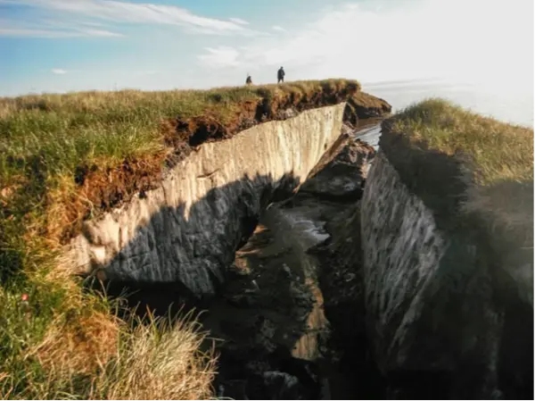
-
Sweden
The Earth Talks through its triple planetary crisis of climate change, pollution and biodiversity loss. Earth observation data that are easy to access and understand can support the global agendas and help the decision-making processes. Europe will continue to be a major contributor to GEO through its Earth Observations program Copernicus and the new Destination Earth initiative, which aims to develop a very high precision digital model of the Earth to monitor and simulate natural and human activity.
Håkan Wirtén
Director General, SMHI, Swedish GEO Principal
The Swedish Space Agency is, together with Luleå Technical University, Research Institutes of Sweden and AI Sweden, developing the Swedish Space Data Lab, to promote innovation, method development and the use of AI with Earth Observation data. The platform that is the Collaborative Ground Segment for Copernicus in Sweden is further developed to Digital Earth Sweden, to further enhance the Swedish capacity of processing and analyzing earth observation data. Digital Earth Sweden is a national innovation hub for Swedish authorities using earth observation data, and for the development of AI-based analysis of the data. The purpose of the lab is to enable increased use of data from space for the development of society for the benefit of the globe. The goal is to get data, technology, and methodology in place to enable systematic development of space-based data, services and applications. Space data is used in a wide range of fields. It is indispensable for, among other things, weather forecasts and monitoring the climate, but it is also extremely important for forestry, agriculture and other fields in which up-to-date information about vegetation and the land surface is needed.
Dr. Selima Ben Mustapha
Head of Earth Observation applications Swedish National Space Agency (SNSA)
Leveraging Earth Observation big data and AI, KTH Royal Institute of Technology has developed innovative methods for urban mapping and urbanization monitoring to support resilient and sustainable urban development, and for early detection and near real-time monitoring of wildfires to support effective emergency response and decision support. The novel unsupervised domain adaptation method developed by KTH can produce high-quality built-up maps and be deployed in any city around the world. Using EO-derived urban data, KTH also developed two Google Earth Engine applications that have been included in the GEO-UN Habitat’s EO4SDG11 Toolkit. The City Definition Generator for SDG11 APP can automatically generate spatial definition of a city extent that is essential for a number of SDG11 indicators. The SDG Indicator 11.3.1 Calculation App can automatically calculate SDG 11.3.1 “Land Use Efficiency” primary and secondary indicators for any city in the world. The SDG11.3.1 Land Use Efficiency app won the 2022 GEO SDG award (Academia) for KTH. KTH also contributed to the UN Habitat’s SDG 11 Synthesis Report to the 2023 UN High Level Political Forum on “Rescuing SDG 11 for a Resilient Urban Planet”. The EO&AI-powered approaches developed by KTH have been tested for early detection and near real-time monitoring of wildfires in numerous sites around the world. The more reliable insights on wildfires not only can enhance emergency response but also improve the estimation of environmental impact of wildfires including biomass loss and CO/CO2 emission. The impactful research has led KTH to be nominated for the Google Geo for Good 2023 Impact Award.
Prof. Yifang Ban
KTH (Royal Institute of Technology Sweden)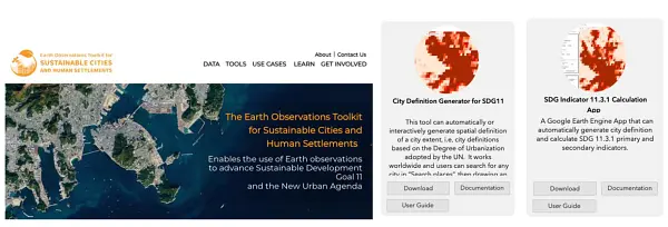
In 2023, the Swedish Board of Agricultural launched an automatic system that follows up activities for all agricultural land in Sweden using Copernicus Sentinel data and geotagged photos. The purpose of the follow-up is to ensure that we pay support to those farmers who manage their land in the correct way. An important part of this is to give farmers a chance to correct their applications of aid to agree with reality, to avoid deductions from the support. In the long run, the follow-up also leads to fewer on the spot controls which will reduce the administrative burden of the agency. Following up agricultural land with satellite images is a requirement that the European Commission places on all member states. The system is intended to be continuously developed over the coming years.
Dr. Niklas Boke Olén
Team Leader - satellite analysis Swedish Board of Agriculture
-

Switzerland
Switzerland plans to introduce a law that facilitates the Use of Electronic Means for the Fulfilment of Government Tasks. It will promote the electronic exchange of Federal business processes. This also includes interactions of authorities with businesses and the population and defines principles for the royalty-free licensing of software (open source software) and for the publication of data of the administration for free use (open government data). This is in line with the principles of the 2023 Cape Town GEO Ministerial Declaration.
Petra Zimmermann
Vice-director of the Swiss Federal Office for the Environment FOEN, GEO Principal
Since 2023, the Swiss Data Cube has partnered with the Brazil Data Cube team to initiate the development of new methodologies for the production of consistent and reliable yearly, medium-to-high resolution (spatial, temporal, thematic) time-series of Land Cover data across Switzerland to inform national environmental/territorial policies and planning.
Dr. Gregory Giuliani
Senior Lecturer/Head of the Digital Earth Unit, University of Geneva & UNEP/GRID-Geneva
The MRI is pleased to continue co-leading and hosting GEO Mountains and support its goals as part of the GEO vision. Though our series of in person regional workshops throughout 2023-2024, we bring together the respective regional research and operational monitoring communities to explore opportunities for creating networks of mountain observatories, exchange data and capacities, and identify joint projects that help improve prospects for data and information access and use.
Dr. Carolina Adler
Executive Director Mountain Research Initiative (MRI) Co-Lead, GEO Mountains
-
The Association of the Geological Surveys of the European Union
-

Trinidad and Tobago, Republic of
-

United Kingdom
This year’s GEO Week comes as I take over as the new UK Principal, and I am excited to take up the mantle from the previous Principal in this unique and valuable international group. My thanks to Dr Robert Bradburne for all his excellent work. It has been an exciting year for the UK Earth Observation (EO) community. The UK government has invested significantly to bolster the high growth sector into the long term, with EO satellites now supporting an estimated £106 billion of UK GDP (5.1%). In November 2022, the UK Government announced over £200m investment for the UK to protect and strengthen the EO sector, enhance our national capability and deliver our National Space Strategy ambitions. In May 2023, ministerial responsibility for civil EO policy transferred to the Department for Science, Innovation and Technology (DSIT) – including GEO principalship. This aligns with the UK’s strategic objective under the National Space Strategy to remain at the forefront of EO technology and know-how. In July 2023, the UK published the National Space Strategy in Action, which defines the next steps we will take in delivering the Strategy, including our civil EO priorities. These priorities set out the ambitious, sector-specific outcomes to deliver long-term sustainable growth and support innovative use of EO for both commercial and public services. Then in September, the UK Prime Minister secured a bespoke deal with the EU that will see the UK participating in the Copernicus component of the EU Space programme from 1 January 2024. This is a landmark moment for scientific and space collaboration between the EU and the UK. It comes at a crucial time, where the Copernicus space infrastructure and its information services will evolve further and their contribution to understanding and acting on environmental and climate change challenges is more important than ever. In my short time as UK Principal, I have already observed GEO’s growing commitment to robust climate action. I am therefore pleased to confirm the UK’s ongoing financial and technical support to the work of GEO programmes, including the UK’s contribution to the Global Ecosystems Atlas – and I encourage other GEO members to do the same. The UK looks forward to co-chairing an event with the GEO Secretariat at COP28 later this year, showcasing the value of space in protecting and restoring nature. In conclusion, this year has been transformative for UK EO, putting us in a strong position from which to shape the future of global EO in partnership with international colleagues. I am confident that the UK’s engagement with GEO will continue to go from strength to strength through its strong network of committed stakeholders, and I look forward to many further achievements in the years to come.
Miriam Grigg
UK GEO Principal, Deputy Director for International, Sustainability, Regulation and Earth Observation Space Directorate UK Department for Science, Innovation and Technology
The UK EO community continues to be very active internationally, including within the GEO programme of activities. International collaborations are fundamental to our research and infrastructure activities and have led to many valued relationships around the world. The UK is particularly focussed on initiatives which can make a big difference through research and innovation supporting societal benefit and policy through more operational activities. Observation of evolving landscapes, ecosystems, wildfire regimes and heatwaves are all key to resilience, recovery, lower costs, and healthier lives. We are keen to see GEO make effective contributions in these areas in support of other agencies and action plans. Climate science and carbon mitigation continue to be critical challenges for UK and world research. The UK is keen to ensure that new satellite missions are supported to achieve their full potential, including future operations, and this includes critical ground-based systems. In much of GEO’s implementations, integrated systems are needed which include in situ data and models; digital twins offer much in coupling current observations with predictive capabilities. As climate change continues to take hold, there is an increasing link between climate resilience and disaster preparedness and response. The UK supports the international EO community to play an active role in demonstrating timely information and sees that countries can work together in GEO to achieve greater impact globally and in-country.
Professor John Remedios
Executive Director of the National Centre for Earth Observation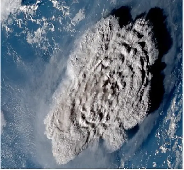
We know that using place as a lens for understanding the world enables society, businesses and governments to respond to global challenges. Gathering and linking data from across a wide range of sources in space and on the ground needs an authoritative foundation layer of data to ensure that we can rely on the answers they are providing. Geospatial organisations have the know-how and the existing data infrastructure needed to make the most of the unique value that space technology offers from increased currency or different sensor types. We have been pleased to support the development of GEO over the last few years working closely with the GEO Secretariat to share our geospatial know-how and contributing to activities such as the GEO Ministerial Working Group on behalf of the UK. I know that GEO is looking forward to starting its next chapter as it moves forward under its new strategy Earth Intelligence for All.
David Henderson
Chief Geospatial Officer, Ordnance Survey
-

United States
-
Vietnam
