
Statements
GEO Week 2022
- Home/
- Events/
- Geo Week 2022 /
- Statements
-
AGRHYMET Regional Centre
Encouraged by GEO and the GEO Member Community we adopted an open EO data policy in 2022. The use of EO data for services and products has since increased spectacularly, with over 12000 users registered in the past year. One of the outcomes is an improved use of alternative energy sources to reduce our carbon footprint.

BAKO Mamane
Remote Sensing and GIS Specialist
-
Australia
-
Cambodia
-

Canada
Canada is proud to have released “Resourceful, Resilient, Ready: Canada’s Strategy for Satellite Earth Observation” in January 2022. The strategy outlines an approach that will guide Canada’s actions and investments related to satellite Earth observation data, technology, and international partnerships, as well as advance and promote common goals. This includes advancing new satellite missions and analytical environments to generate solutions for climate change mitigation and adaptation, particularly in Canada’s Arctic.
David Harper
GEO Principal for Canada, and Director General, Meteorological Service of Canada, Environment and Climate Change Canada
GEO activities and the EO community have become central in helping Canada create the innovative Census of Environment by providing a fertile ground for the exchange of ideas and solutions required to make the initiative a success.
François Soulard, Ph.D.
Research Manager Census of Environment Statistics Canada
GEO BON, a network of over 2,300 members across 134 countries worldwide, provides open data and knowledge to support research and conservation action for biodiversity. GEO BON offers a blueprint for a Global Biodiversity Observation System. To do this we are building data portals and online tools to allow a wide range of users to collect and analyze biodiversity data (from Earth observations to in-situ measurements) and produce indicators designed to assess progress and inform decision making for biodiversity conservation. In addition, GEO BON is providing scientific expertise for the post-2020 global biodiversity framework of the UN Convention on Biological Diversity, to be negotiated at COP15 in Montreal (December 2022).
Andrew Gonzalez
Professor McGill University, co-chair of GEO BON, and Quebec Centre for Biodiversity Science Director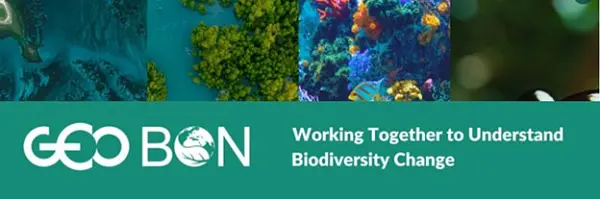
-

China
United at the first China GEO Conference, China GEO community further strengthens in-depth research to address common global challenges and carry out cooperation on food security early warning, ecological environment monitoring and climate change response. We hope to help building a Community with a Shared Future for Mankind through a joint effort.
ZHAO Jing
Director General, National Remote Sensing Centre (NRSCC), Ministry of Science and Technology of China (MOST)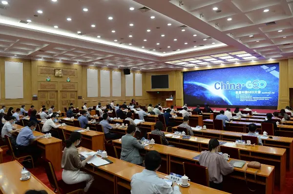
Established in 2016, Collaborative network on Disaster Data Response (CDDR) is responsible for coordinating the provision of Chinese high-resolution satellite data and disaster analysis products to disaster-affected countries. By October 2022, the CDDR mechanism had provided information services to cope with 35 major disaster emergency events such as earthquakes, volcanoes, floods, storm surges, wild fire and explosions in 25 countries.
LIU Zhichun
Deputy Director General, National Remote Sensing Centre (NRSCC), Ministry of Science and Technology of China (MOST)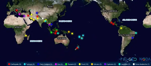
Two new members of the Fengyun satellite family, Fengyun 3E and Fengyun 4B, were put into operation on June 1, 2022. We provide various forms of data sharing, downloading and processing services. Applications using Fengyun satellite data, especially those aiming at GEO priorities including sustainable development, climate change, and disaster resilience, are very welcome.
WANG Jingsong
Director General of National Satellite Meteorological Center (NSMC) China Meteorological Administration (CMA)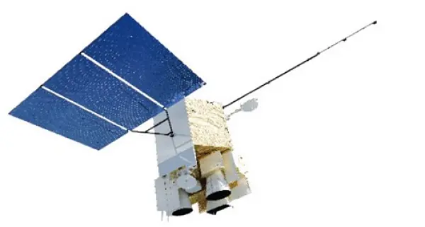
Under the GEO Community Activity “In-Situ Observations and Applications for Typical Ecosystem Status of China and Central-Asia”, a 12-day training workshop on ecosystem monitoring in China and Central Asia was organized with 30 participants from 6 countries, which enhanced monitoring capacity of technicians and research staff from the Central Asia for their better environment status review.
ZHANG Xinyu
Professor, Institute of Geographic Sciences and Natural Resources Research, Chinese Academy of Sciences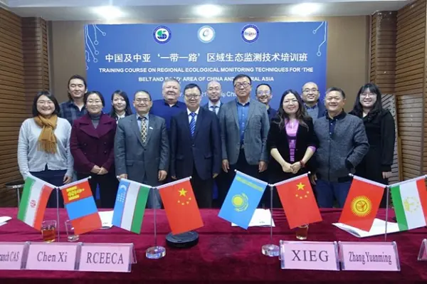
From 2020 to 2022, GEOARC advocated analysis-ready open data by integrating multiple EO data to generate common products. GEOARC released 4 annual reports and 41 datasets for ecosystem and environmental monitoring to support the GEO priorities, organized more than 10 task group sectorial meetings in AOGEO Symposium, GEO Week side events, training and other activities.
LIU Qinhuo
Professor, Aerospace Information Research Institute, Chinese Academy of Sciences (AIRCAS)
The Zero Hunger Goal is an important part of UN SDGs and an important mission of GEO. The global agricultural remote sensing monitoring cloud service platform, CropWatch was developed since 1998. Over the past 20 years, CropWatch has been providing public information sharing services on agricultural monitoring, enhancing agricultural capacity building in developing countries, and increasing the transparency of global agricultural information. CropWatch will follow GEO's strategic vision to further advance the accessibility and EO application to decision-making for the benefit of humankind.
WU Bingfang
GEOGLAM Co-chair, Lead of CropWatch Team Professor, Aerospace Information Research Institute, Chinese Academy of Sciences (AIRCAS)
Encouraged by GEO and the GEO Member Community, we have conducted remote sensing monitoring of habitat suitability and dynamic forecasting of occurrence risk for globally significant migratory and epidemic crop pests and diseases (desert locust, fall armyworm, wheat rust, etc.), and published scientific reports. The outcomes have been adopted, shared, and released more than 100 times by domestic and international government departments, organizations, institutions, and industrial enterprises. With these services, we have promoted the practical application of products and contributed to the achievement of SDG and disaster risk reduction objectives.
HUANG Wenjiang
Professor, Aerospace Information Research Institute, Chinese Academy of Sciences (AIRCAS)
In June 2022, supported by GEO and AOGEO community, the 5th AOGEO Workshop was held online with the adoption of 2022 AOGEO Announcement. More than 130 delegates from 16 countries attended this workshop online and over 500 people watched the broadcast. The theme of this year is “Harmony and Empowerment: Accelerate Action and Development”. AOGEO will accelerate action to promote synergistic development and regional empowerment in response to regional needs.
GU Xingfa
Member of GEO Program Board Co-chair of AOGEO Coordination Board Professor, Aerospace Information Research Institute, Chinese Academy of Sciences (AIRCAS)
On September 20, China announced to make the data acquired by the Sustainable Development Science Satellite (SDGSAT-1) launched by China in November last year available globally to assist countries in sustainable development research and decision-making. China released the Report on Big Earth Data in Support of the Sustainable Development Goals (2022), which studies the interactions among SDG indicators and their integrated evaluations, providing scientific evidences for quantitative and systematic evaluating the implementation of SDGs at national, regional and global level.
GUO Huadong
Director General, International Research Center of Big Data for Sustainable Development Goals Professor, Aerospace Information Research Institute, Chinese Academy of Sciences (AIRCAS)
-

Committee on Earth Observation Satellites
Paths to Sustainability: from Strategy to Practical Measures
Dr Selma Cherchali
Head of the Earth Observation Department Strategy Directorate Centre National d'Études Spatiales (CNES)
-
Costa Rica
Costa Rica has been able to strengthen its capacity to take advantage of the potential of Earth Observations, thanks to its participation in the various groups, programs and initiatives developed by GEO. We increased the capacity and integration of our spatial data infrastructure, implemented new mechanisms for forest monitoring and identification of essential life support areas, studied innovative mechanisms for modeling ecosystem services, and evaluated new urban monitoring tools. In 2023, we expect to expand our involvement by integrating more Costa Rican institutions and organizations with GEO and AmeriGEO activities.
Rafael Monge
Director, National Center of GeoEnvironmental Information, Ministry of Environment and Energy of Costa Rica
-
European Association of Remote Sensing Companies
The European Earth Observation private sector is committed to supporting the 2030 Agenda for Sustainable Development and the three global priority engagement areas of GEO. EARSC is convinced that the effective combination of governments, academia and private sector is fundamental to achieving these goals. EARSC’s involvement as a GEO Participating Organisation has resulted in a marked increase in the interest of European companies in GEO.
Emmanuel Pajot
EARSC Secretary General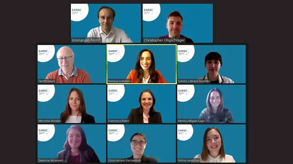
As EARSC Chair, I consider it very important to maintain a sustained dialogue with organizations such as GEO and therefore it is a great asset to have EARSC as single voice representing and putting forward the perspective of the European EO services industry
Marc Tondriaux
EARSC chair representing the Board of Directors
The EU Copernicus programme is a key asset contributing to GEO. Through its involvement in EuroGEO and within the EuroGEOSS showcases project, e-shape, EARSC is leading the user uptake, capacity building and liaison activities supporting the GEO Work programme. EARSC is supporting the engagement of the private sector in GEO working groups and recently contributed to the Mapping the Engagement of the 2020-2022 GEO Work Programme in Climate Action, Disaster Risk Reduction, and Capacity Development.
EARSC is committed to highlighting the significant value delivered by EO data and services to citizens, corporations and governments. EARSC actively stimulates the uptake of services based on satellite data, to bring the benefits of space to society” EARSC strengths the relations with users “Copa-Cogeca works to ensure that all farmers and agricooperatives have access to a wide range of safe technologies that will enable EU agriculture to improve on sustainability whilst remaining competitive. Working hand in hand with EARSC to bring to the public debate the challenges and opportunities for the agricultural sector is a privilege. We work together to identify the farmers' needs and discuss the potential of EO
Daniel Azevedo
Copa-Cogeca
-

European Centre for Medium-Range Weather Forecasts
Answering key societal questions on how to build a resource-efficient and climate resilient society requires a continuous engagement with a variety of users, including the GEO community. In order to unlock the full potential of climate products and services we connect core users with technical experts and with the scientific community to develop innovative solutions based on cutting-edge technology and a diversity of expertise.
Chiara Cagnazzo
Senior Scientific Officer, Copernicus Climate Change Service - ECMWF
The Copernicus Atmosphere Monitoring Service (CAMS) products enable exposure assessment of reversible (e.g. soiling by particles) and irreversible (e.g. corrosion by chemicals and UV fading) degradation of surfaces of historical buildings and monuments. This is an example of how CAMS can support GEO and the Urban Heritage Climate Observatory initiative.
Stijn Vermoote
Head of User Engagement - ECMWF
ECMWF is very proud to run the GEOGloWS-ECMWF streamflow prediction system supporting the GEO community, and to be part of this amazing collaborative effort. With its kilometre-scale resolution, GEOGloWS-ECMWF streamflow prediction system delivers locally relevant, user-driven hydrological (in particular for flood) forecast solutions that can benefit developing regions around the world, complementing the Copernicus Emergency Management Service GloFAS, designed for larger transboundary rivers.
Ervin Zsoter
Developer of GloFAS (Global Flood Awareness System) - ECMWF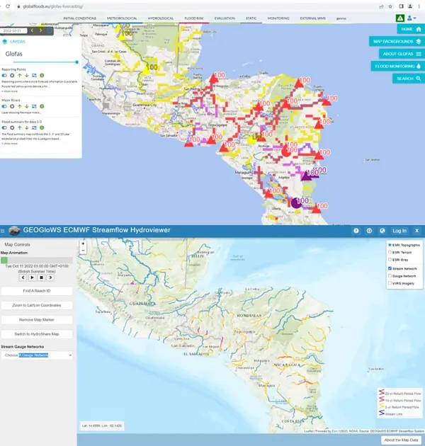
-
European Commission
The Copernicus Emergency Management Service provided constant support during one of the worst wildfire season of the last decades that hit Europe in the Summer 2022. In the months of July and August, many records have been broken, in terms of number Rapid Mapping activations in a short lapse of time, but also in terms of intensity and consequential damages.
Mauro FACCHINI
Head of Earth Observation Unit Directorate General for Defense Industry and Space European Commission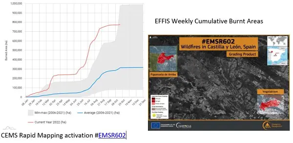
Since January 2021, thanks to the support of the European Commission, the European Environment Agency (EEA) is running a three-year project focused on improving the sharing and use of in situ Earth observation data in support of environment and climate policies. An important focus of this project lies on supporting the activities carried out by the GEO Data Working Group (DWG), in particular on in-situ data. Under the co-leadership of EEA, the In Situ Subgroup of the DWG is engaging with GEO Work Programme activities, identifying common barriers to in-situ data sharing and use and proposing ways to address these barriers. We are setting up a tool for the GEO community that will facilitate the systematic collection of in situ data requirements, following the successful model of CIS2 (Copernicus In Situ Component Information System). In close collaboration with GEO Work Programme activities, we will reach out to existing in-situ networks that are best placed to provide access to required data. We expect that these activities will improve the availability and accessibility of in-situ data, in line with the In Situ Data Strategy for GEO
Chris STEENMANS
Head of Programme Data and Information Services European Environment Agency
The AFRICULTURES GEO community activity, with funding from the European Commission’s H2020 programme, has developed a digital platform on remote sensing services for food security in Africa, with special attention for climate, crops, drought, land, livestock, water and weather. Practical applications are developed to improve agricultural policy and extension services on irrigation support and food security early warning (Tunisia), regional pastoral information (Niger), early warning based on crop monitoring (Ghana), drought information for livestock farmers (South Africa), crop monitoring and yield forecasting (Mozambique), crop and crop condition mapping and water quality (Kenya) and crop monitoring and yield forecasting for national index insurance (Rwanda). AfriCultuReS contributes to the GEO Global Water Sustainability initiative (GEOGLoWS). AfriCultuReS will continue in the form of national and regional partnerships.
Juan Suarez Beltran
Business Development Manager GMV AEROSPACE AND DEFENCE SA, Spain
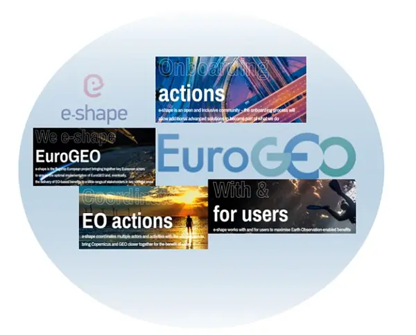
e-shape is a unique initiative under the EU-funded Horizon 2020 programme started in May 2019 that seeks to accelerate a breakthrough in the European Observation sector and serving GEO through further shaping the EuroGEO initiative. e-shape develops and promotes European EO capabilities with and for the users through a co-design approach with as a key element to bring new partners on-board” e-shape supports the Canberra declaration by involving the private sector in the development of operational 37 pilots (27 original pilots and 10 on-boarded), and developed strategic activities to support GEO and EuroGEO. The 37 pilots developed by the project are discoverable from the GEO portal and contribute to a series of GEO activities in the current WP. Amongst other key results such as the development of a Data Management Self-Assessment Tool allowing to assess GEO principles and FAIR principles for all GEO activities, the co-design methodology developed within e-shape will support the preparation of the post-2025 GEO Work programme through the set-up and evaluation of an incubator/integration approach inspired from the project. Guidebooks will be made available soon to the GEO and EuroGEO communities on Implementation of operational services and Capacity building. The sustainability booster developed within the project will support the EO-based products and services towards sustainability. e-shape has also explored the future governance of EuroGEO and will share its views with the European Caucus at the next EuroGEO workshop to be held from 7 to 9 December 2022 in Athens, Greece.
Prof. Thierry Ranchin
Director of Centre Observation, Impacts, Energy, MINES Paris – PSL /ARMINES Scientific coordinator of e-shape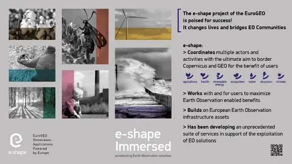
The European Commission has taken the initial steps towards the design and prototyping of EuroGEOSS - a virtual digital ecosystem, with the objective to show how wide range of European and National capacities and products can be interconnected. The objective of this investigation is to validate what a fully scaled up digital ecosystem could look like. It is conceived as an ecosystem for the GEO community, enabling its main stakeholders –whether policy makers, scientist, or businesses– to build value-added solutions based on Earth Observation data assets and services. A user centric approach will be adopted in the design and implementation of the prototypical virtual ecosystem, following recommendations highlighted in the Mid-Term Evaluation (MTE) report of the GEO Strategic Plan. In line with this, the initial steps undertaken have focused on the identification of community members' needs in terms of products, services and functionality, and translating these into technical requirements to be addressed by the future EuroGEOSS.
Josep SOLER GARRIDO
Team Leader Joint Research Centre European Commission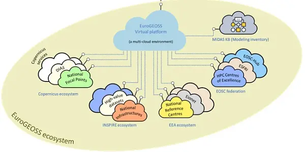
Advancing the understanding and adoption of open innovation approaches in Geospatial and Earth Observation is a key objective to enable impactful research addressing grand societal challenges. In 2022, the International Society for Photogrammetry and Remote Sensing (ISPRS) has established a Working Group acting at the interface between ISPRS Technical Commissions on Spatial Information Science, Remote Sensing and Education and Outreach. The WG, led by representatives of the European Commission and the European Space Agency, will establish strategic partnerships with key organisations in the Earth Observation domain, including GEO and its European counterpart EuroGEO in particular. Aligned with European approaches, the WG will advance knowledge in the investigation of technological, social, organisational and legal enablers and barriers for the development of open approaches in the Geospatial and Earth Observation domains, pertaining to open data, open source software, open standards, open education and research, across the dimensions of accessibility, inclusiveness and reproducibility.”
Anca ANGHELEA
Open Science Platform Engineer, Science, Applications & Climate Department Directorate of EO Programmes, European Space Agency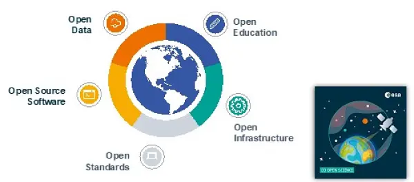
The TWIGA project, supported by the European Commission’s H2020 programme, developed services for Africa based on in situ data for irrigation, crop management, weather information for small farmers, agricultural index insurance, flood early warning, dam reservoir management, cross-border water management, livestock heat stress, and solar energy, starting in Ghana, Kenya, Uganda, Mozambique and South Africa. TWIGA delivered in situ datasets on weather, GNSS, and soil moisture to GEOSS. New sensors were developed for weather, water and climate applications that are considerably cheaper than the current ones. For its water-related components TWIGA is part of the GEO Global Water Sustainability (GEOGLoWS) initiative. TWIGA partners and other parties will continue to expand the use of the services across Africa, making use of the TWIGA portal.
Nick Van de Giesen
Technical University Delft
Resilient coastal cities are one of the big challenges for urban sustainability. But moving from resilience theory to practical implementation will require resilience strategies involving all the stakeholders. The GEO Citizen Science Initiative could fill the gap to elevate the value of citizen science communities and data from local to global scales. The ongoing projects to integrate citizen observations in pan-European infrastructures, such as Cos4Cloud that connects Citizen Observatories with the European Open Science Cloud -EOSC-, can facilitate and increase the use of Citizen Science in GEO by supporting global coordination and collaboration within and beyond GEO
Jaume PIERA
H2020 Cos4Cloud coordinator and researcher from the Institute of Marine Sciences (ICM-CSIC)
-
European Organization for the Exploitation of Meteorological Satellites
EUMETSAT ensures continuous operation of the GEONETCast system over Europe and Africa, allowing many users to access Earth observation in real time and in area with insufficient internet capacity. About 400 reception stations are installed across Africa.
Phil Evans
EUMETSAT Director General
-
Finland
Finland is putting energy in strengthening ArcticGEOSS by improving preparedness to wild fire. Several finnish EuroGEO services are already active for hydropower, forestry, urban resilience and lake ice, all with increasing usage every year.
Mikko Strahlendorff,
GEO Principal, Finnish Meteorological Institute
-

Frontier Spatial Information
FrontierSI is delighted to be working with the DE Africa Team to improve the adoption and use of the DE Africa platform across the continent. We are already seeing many examples of the platform and data being integrated into existing workflows to improve decision making.
Dr Graeme Kernich,
Chief Executive Officer, FrontierSIDigital Earth Australia provides a snapshot of the entire Australian landscape every five days, giving us so much detail about water availability, the development of our regions and cities and the productivity of our land. The value of this kind of technology to businesses is unlimited.
Senator The Hon Matt Canavan
Minister for Resources and Northern Australia Australian Government
-
Germany
The Global Geodetic Centre of Excellence (GGCE) will be formally established at the UN-Campus in Bonn/Germany by the end of 2022 and start to operate in early 2023. Its establishment has been decided by UN-GGIM back in 2020. With the GGCE, Germany supports the establishment of a sustainable globally coordinated geodetic infrastructure as a basis for Earth Observations and Navigation applications. It allows, for instance, more efficient and accurate monitoring of sea level or earth crust changes. The GGCE will in particular support developing countries and foster open exchange of geodetic data. The Federal Agency for Cartography and Geodesy (BKG) is an international geodetic reference as operator of geodetic observatories on three continents and will support the work of the GGCE with its expertise. Germany will – through its Federal Agency for Cartography and Geodesy (BKG) –contribute to the success of the GGCE by providing the necessary financial means to establish and start the GGCE.
Paul Becker
President, Federal Agency for Cartography and Geodesy (BKG)
The Federal Institute for Geosciences and Natural Resources (BGR) carries out several development cooperation projects with African, Latin American and Asian partner countries. Many different, mainly freely available satellite data, digital elevation models and geological survey data are used in these projects, e.g.: In cooperation with the Geological Survey of Bangladesh (GSB), the project “Geo-Information for Urban Planning and Adaptation to Climate Change” supports the planning agencies in the pilot cities of Kushtia, Faridpur, Satkhira, Barisal, Sirajganj and Khulna with remote sensing observations based on Copernicus Sentinel and Landsat data. Linking e.g. land-use with inundation data and river-course monitoring with InSAR-derived multi-temporal ground motion for the pilot city of Faridpur enables a comprehensive view on geo-hazards, building ground suitability and the underlying processes within a planning area. The project “Geothermal Energy in East Africa” includes cooperation with the Djiboutian project partner Office Djiboutien de Développement de l’Énergie Géothermique (ODDEG). The regional capacity for geothermal exploration in four countries of SICA ("Central America Integration System"), which acts as a political partner, is realized through activities in Costa Rica, Nicaragua, El Salvador, and Guatemala. Several remote sensing methods are applied to provide support for current geothermal exploration studies.
Dr. Michaela Frei
Head of Unit “Remote Sensing”; Department “Geoscientific Information, Geoscientific Cooperation”; Federal Institute for Geosciences and Natural Resources.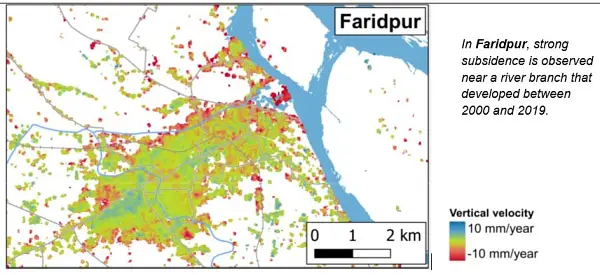
“The Environmental Mapping and Analysis Program (EnMAP) is a German hyperspectral satellite mission that aims at monitoring and characterizing Earth’s environment. EnMAP measures key dynamic processes of Earth’s terrestrial and aquatic ecosystems by extracting geochemical, biochemical and biophysical parameters. The mission was successfully launched in April 1st 2022. Routine operations has started on November 2, 2022. Data is now provided with a free and open data policy to the global scientific user community. To visualize and process imaging spectroscopy data the EnMAP Toolbox was developed and is provided freely to the community. And with the online learning initiative HYPERedu hosted on the EO-College Platform, we support the GEO community in practicing the use of imaging spectroscopy for local environmental challenges and global cooperation. Further information on the mission, news and announcements of opportunities are available on https://www.enmap.org/.”
Godela Rossner
Head of Department “Earth Observation”, German Space Agency at DLR
-

Ghana
GEO has been instrumental in proving and access to different sources of with EO data varied spatial and temporal resolution and computing platform to transform the EO data into useful information for evidence-based decision making – Digital Earth Africa Plaform
Prof Shilo Osae
Ghana Space Science and Technology Institute
GEO -earth observations into decisions for a better Africa, a renewed World – is pivot for Trust, Transparency and Governance for changing the fortunes of Africa for the Africa We Want Agenda 2063.
Prof Amos Kabo-Bah
Co-Chair, GEO LDN Initiative Dean, International Relations Office, University of Energy and Natural Resources, GhanaGEO has supported us in organizing training for stakeholders on monitoring SDG goal 6 using EO data on Amazon Web Services. This enabled us to train over 200 participants with diverse backgrounds in Ghana on monitoring SDG goal 6 using the AWS platform.
Kofi Asare
Manager, Remote Sensing, GIS & Climate Center, Ghana Space Science and Technology Institute
-
Gigabit European Academic Network
-

Greece
Greece, consistently dedicated to promoting the use of Earth observation, is co-organizing this year, together with the European Commission, the 2022 edition of the EuroGEO workshop “Towards an integrated and convergent EuroGEO”. The workshop will take place as a physical event in https://www.electrahotels.gr/hotels/electra-palace-athens/Athens, Greece, from 7 to 9 December 2022. The local organization is overtaken by the General Secretariat for Research and Innovation of the Hellenic Ministry of Development and Investments, and the Greek GEO Office. During the workshop, we will be, among others, offering networking opportunities to the participants, look for synergies across different projects and initiatives, and identify opportunities to work under a nexus approach.
Prof. Christos ZEREFOS
Greek GEO Principal, Academy of Athens
The prominent position of Earth Observation, Satellite Imagery and Geo-spatial Data in Official Statistics is indisputable. European Statisticians had already ratified this fact in 2021 DGINS Conference. The recent Europe-wide Censuses results will be delivered at a 1km2 grid, proving our strong belief in the need for geospatial disaggregation and enabling integration of EO in socio-economic data. The Hellenic Statistical Authority (ELSTAT) carries this discussion further through the Memorandum of Cooperation with the Greek GEO Office and stands ready to steer projects as data provider, while exploring possibilities of using EO data in Official Statistics.
Dr. Athanasios Thanopoulos
President, Hellenic Statistical Authority (ELSTAT) Chairman, Partnership Group of the European Statistical System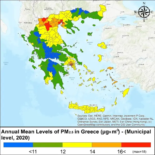
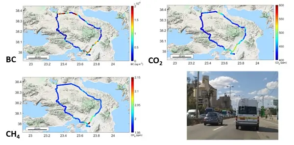
Eastern Mediterranean and Middle East (EMME) is a crossroad of pollutants from Europe, Africa, Asia, and America. Additionally, EMME is an important climatic hot spot region with atmospheric temperature increasing faster than the world mean. Regarding atmospheric health parameters, the levels of ozone and particulate matter (PM) in the EMME often exceed the limits set by EU and WHO with significant health impacts on the population. On the other hand, EMME is an under sampled area in terms of continuous monitoring of greenhouse gases and short-lived climatic sensitive parameters (i.e. ozone, aerosols and clouds). During the last few years, Greece, as a member of the European Infrastructures ACTRIS and ICOS and in order to fill these gaps, initiated two important observation projects named PANACEA and CLIMPACT, dealing with short-lived climatic sensitive parameters and greenhouse gases, respectively. It is expected that the phase two of these projects in the coming years, will reinforce the role of the Greek community in the European Observation capacity environment and will provide new data to help decision makers to design a sustainable future.
Prof. Nikolaos Mihalopolos
To safeguard natural capital of soils, in a continuously volatile landscape of reduced resources and environmental changes and pave the way for the development of evidence-based conservation recommendations for policies and sustainable services for relevant economic operators, it is essential to improve capacities for soil health monitoring by adopting multidimensional and integrated approaches. In this context the Interbalkan Environment Centre in collaboration with the Aristotle University of Thessaloniki supports the evolution of EO-based soil mapping tools via the synergistic use of AI algorithms, process-based simulations, and climatic projections, to generate very high spatial resolution and enhanced spatial soil health indicators. In 2022, within the framework of ESA WORLDSOILS project and H2020 EIFFEL we have analysed petabytes of Sentinel-2 data to feed interpretable AI algorithms in support of the National Paying agencies by providing them annual maps of soil carbon sequestration over croplands. This fully aligns with the objectives of SDG 15.3.
Prof. George Zalidis
Professor, Director of the Interbalkan Environment Center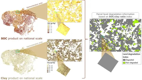
-

India
Government of India has opened the potential of the space sector for greater participation of Private Sector in space activities and Govt. space agency to focus on research and development and meet the requirements of national imperatives. Indian National Space Promotion and Authorization Centre (IN-SPACe) has been positioned for facilitating and regulating of space activities in India. Also, to better understand the observational requirements of the user community and for optimal utilization of the space based observational asset, the Space Applications Management Systems (SAMS) mechanism has been established.
Shantanu Bhatawdekar
Scientific Secretary, ISRO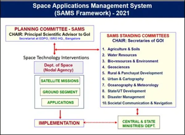
-
International Institute for Geo-Information Science and Earth Observation
Our mission is capacity development, where we apply, share and facilitate the effective use of geo-information and earth observation knowledge and tools for tackling global wicked problems. Our purpose is to enable our many partners around the world to track and trace the impact – and the shifting causes and frontiers – of today’s global challenges. We are here to identify and understand vulnerability, and to use geospatial solutions for converting it into resilience, thereby contributing to the establishment of sustainable living environments anchored in an inclusive society. We realize this in close collaboration with the GEO community. As of 2018, ITC supports a secondment to the GEO secretary on Capacity Development and Impact design. ITC staff members are actively involved in this GEO network and provide support to several GEO flagships and initiatives as participant in regional events, as members of the sub-groups or as co-chair. Our Open Science officer coordinated the development of GEO’s Open Science/ Knowledge Statement.
Prof. Dr. Freek van der Meer
Dean of ITC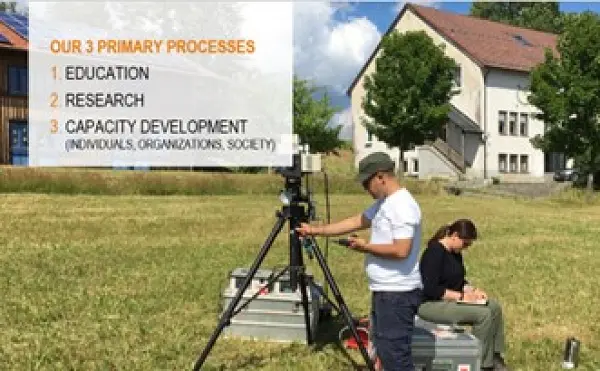
Our vision is of a world in which researchers, educators and students collaborate across disciplinary and geographic divides with governmental and non-governmental organisations, institutes, businesses and local populations to surmount today’s complex global challenges and to contribute to sustainable, fair, digital societies. As such we are shaping individuals (fostering ownership and talent), connections (outside in & inside out), and society (a quest full of challenges). Being part of the global GEO network assures access to worldwide knowledge and provides opportunities for collaboration and co-creation of tools, training/education materials and innovative technologies. In the context of ITC’s activities in geospatial technologies, remote sensing, planning & governance four profiling themes have been defined. GeoAI Combines innovations in geospatial technologies with the rapid growth of methods in AI and big data, with the aim to responsibly translate complex and contextual data in useful information GeoHealth Understand the drivers behind spatial patterns in health and disease via a dynamic approach, and develop context-specific response strategies Resource security Aims at fair and sustainable use of our natural environment, and security and planning of environmental resources such as food, water, biodiversity, minerals, energy, and land, and their equitable availability for societies Disaster Resilience Integrating hazard assessment and disaster risk management into strategic planning and sustainable development
Prof. Dr. M.J. Kraak
portfolioholder Capacity Development & Institutional Strengthening
ITC actively supports the GEO impact-oriented approach on strengthening the capacities of the GEO community to acquire, share, store, maintain and fully utilize Earth observation data and information in the decision-making process. The GEO Capacity Development Working Group provides support to the different working groups of the GEO Flagships, Initiatives and Regional GEO’s to develop strategies and operational guidelines to support the CD activities. Seminar series on best Capacity Development practices enhances the capacities of the GEO community to achieve sustainable impact. ITC currently supports Geo by developing a strategy to enhance the societal impact of the regional GEO’s, national networks, cluster activities, knowledge packages and GWP flagships and initiatives.
Joost Teuben MSc
Senior Capacity Development and Impact Coordinator GEO - ITC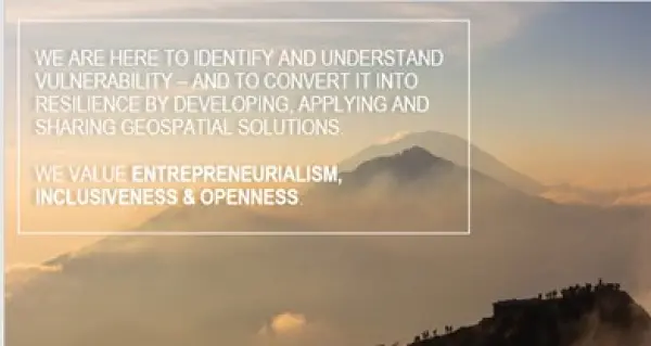
-
International Society for Digital Earth
The International Society for Digital Earth (ISDE) promotes the implementation of the Digital Earth vision aiming to develop a Digital Replica of the Earth addressing the changes in technology, science and society. ISDE contributes to GEO by facilitating academic exchange and supporting science and technology innovation, education, and international collaboration.
Alessandro Annoni
President, ISDE
ISPRS and ISDE are both member associations of GEO. On June 2022 they signed a Memorandum of Understanding to further develop cooperation in the areas of Digital Earth, photogrammetry, remote sensing, spatial information, data science and other activities that they deem mutually beneficial. Together they want to contribute to GEO by promoting openness and ethics in education and research.
Zhen Liu
Executive Director, ISDE
ISDE published the first book on "Manual of Digital Earth". This open access book offers a summary of the development of Digital Earth over the past twenty years. By reviewing the initial vision of Digital Earth, the evolution of that vision, the relevant key technologies, and the role of Digital Earth in helping people respond to global challenges, this publication reveals how and why Digital Earth is becoming vital for acquiring, processing, analysing and mining the rapidly growing volume of global data sets about the Earth. The open access book can be accessed for free at : https://link.springer.com/book/10.1007/978-981-32-9915-3
Huadong Guo
Honorary President, ISDE
The 9th Digital Earth Summit on “Digital Earth to Bridge Digital Divide for Attainment of SDGs” was held in Chennai, India on 6-8 September 2022. It was organized by the ISDE and the Institute of Remote Sensing, at Anna University. The Summit contributed to GEO by advancing research through the engagement of young professionals and students. Concepts of utilizing earth observation with AI/ML, IoT integration and skill next generation workforce on Earth Observation were discussed at the Summit.
Shaik Mohamed Zaffar Sadiq Mohamed Ghouse
Vice President, ISDE
The International Journal of Digital Earth (IJDE) and the Big Earth Data are the two academic journals of the ISDE. IJDE aims to publish research on Digital Earth theories, technologies and applications. Big Earth Data aims to provide a platform for promoting 'big data' sharing, processing and analyses, thereby revolutionizing the cognition of the Earth's systems. Both contribute to GEO by advancing research on data access and sharing.
Changlin Wang
Secretary General, ISDE
-

Italy
Italy is strengthening the coordination amongst national experts involved in Earth Observation (EO) domains through the GEO-ITALY Group (www.geoitaly.org). The GEO-ITALY overarching goal is to reinforce the synergies amongst involved institutions in Italy, thus facilitating a broad range of capacity building and outreaching activities to stakeholders and policy makers both at national and international level. Members of GEO-ITALY are Representatives of the Ministry of Environment and Energy Security and and scientists, researchers and managers employed in several Institutes of the National Research Council of Italy, in the National Institute of Geophysics and Volcanology (INGV), in the Italian National Institute for Environmental Protection and Research (ISPRA), in many other public institutions in the Country, such as the Italian Space Agency (ASI) and the Euro-Mediterranean Center on Climate Change (CMCC), as well as in private companies such as PLANETEK and e-GEOS.
Nicola Pirrone
GEO Principal of Italy
The Global Observing System for Mercury (GOS4M) Flagship main challenge is to foster the sharing of monitoring data and modelling tools to support the policy implementation. GOS4M (www.gos4m.org) is aimed to federate existing networks, monitoring programmes and observing infrastructures – currently it provides a link to the Global Mercury Observation System (GMOS – www.gmos.eu) and major existing regional networks. During the last year GOS4M developed the Knowledge Hub aimed to support the achievement of the objectives of international programmes and conventions related to mercury pollution which include UNEP, Minamata Convention on Mercury (MCM) Secretariat, UNECE-LRTAP and 2030 UN Agenda on SD. Special attention is paid to support all interested Parties in the implementation of the MCM. To this end global comparable monitoring data, validated models and policy interoperable tools are provided as part of the GOS4M Knowledge Hub designed to evaluate the relationship between cause and impact of mercury contamination, analyse cost-effective strategies aiming ot reduce the mercury contamination at regional and global scale and co-design policy scenarios aiming to achieve the target of the MCM. GOS4M is contributing to the GEO Knowledge Hub.
Nicola Pirrone
Research Director CNR - Institute of Atmospheric Pollution Research
Italy is continuing its activity aiming to improve discovery and access to data, information and knowledge and to support and further develop the GEOSS Platform as an open and public global infrastructure for data sharing and knowledge generation. Italy continues operating and advancing the GEO Discovery and Access Broker (GEO DAB) framework as one of the key components of the GEOSS Platform. Italy carries out activities for knowledge generation and management developing the Virtual Earth Laboratory (VLab), a knowledge platform for model sharing and running in multicloud environments. Italy is co- chair of the GEOSS Platform Operation Team (GPOT) and member of the GEO Infrastructure Development Task Team (GIDTT). It also participate to the activity aof the GEO Data Working Group and its soub-groups. For the advancement and utilization of the GEOSS Platform, collaborations are ongoing with ESA, EC-JRC, USA (USGS), Germany (DWD), Switzerland (University of Geneva), China (Ministry of Science and Technology), Chile (Ministerio de Bienes Nacionales).
Paolo Mazzetti
Head of the Florence Division CNR - Institute of Atmospheric Pollution Research
The Paris Agreement is one of the three GEO Engagement Priorities. To achieve its targets, systematic and long-term earth observation data are needed, in order to: improve carbon budgets, reduce uncertainties of national inventories, and provide decision makers with reliable information. Italy is supporting, by co-leading the secretariat, the GEO Carbon and GHG Initiative, which has the objective of developing an operational global observing system for monitoring and evaluating changes in the carbon cycle and GHG emissions. Furthermore, through a dedicated activity within the H2020 project VERIFY, Italy (CMCC), is contributing in creating the links between the “Observation-based system for monitoring and verification of greenhouse gases” foreseen by the project and GEO, ensuring the coordination with global data synthesis efforts.
Lucia Perugini
Senior Scientiific Manager Fundation CMCC - Euro-Mediterranean Center on Climate Change
As a further Italian contribution to GEO, GEO Mountains (www.geomountains.org/) aims to connect and facilitate access to diverse sources of mountain observations and information regarding drivers, conditions and trends in biophysical and socio-economic processes of change, at different scales. GEO Mountains advances our capacity to combine data on mountains to meet emerging scientific and policy knowledge needs, thereby 1) enhancing our understanding of processes of global change in mountain regions, 2) improve our ability to provide policy and investment relevant advice, and 3) assess SDGs in mountain areas.
Elisa Palazzi
Associate Research Scientist CNR – Institute of Atmospheric Sciences and Climate and Professor at the University of Turin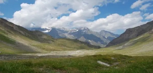
A further contribution of Italy to the many GEOSS Ecosystems tasks is offered by the GEO ECO (GEO Global Ecosystem) Community Activity and Action Group, co-lead by CNR. GEO ECO builds up and extends the approach used in the European Horizon 2020 ECOPOTENTIAL project, led by CNR, and from a few other initiatives, to other protected areas in Europe and in other continents. GEO ECO aims to use available Earth Observation data, research results and tools on a global scale for enhancing knowledge on natural ecosystems, identifying protected areas (PAs) of international relevance as focus areas for its activities, as they are aimed to preserve natural ecosystems, and thus have a high intrinsic value for human societies. In Italy, a key PA will be the Gran Paradiso and the Alta Murgia National Parks, also involved in ECOPOTENTIAL, the former H2020 project on Earth Observation data for ecosystems in protected areas supporting GEO (2015-2019). The detection and modelling of the state and development of natural ecosystems in PAs is a priority for the monitoring the advancement of the SDG 14 and 15. It also extends its analysis to unprotected areas. GEO ECO is adopting the view of ecosystems as "one physical system" with their environment, characterized by strong geosphere-biosphere-anthroposphere interactions across multiple space and time scales. The GEO ECO implementation plan can be downloaded here: www.earthobservations.org/documents/gwp20_22/GEO-ECO.pdf
Antonello Provenzale
Director, CNR - Institute of Geoscience and Earth Resources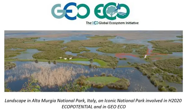
The Italian Space Agency (ASI) actively supports GEO Initiatives related to Disasters Risk Reduction like GEO-GSNL and GEO-DARMA. ASI regularly provides thousands products from its national asssets (mainly COSMO-SlyMed, but also PRISMA and SAOCOM over ASI Area of Interest) to all the 13 Supersites and Natural laboratories all over the world and to pilot projects whose purpose is to demonstrate the value of earth observation data for Disaster Risk Reduction and to build regional capacity in this sector.
Giovanni Rum & Simona Zoffoli
Agenzia Spaziale Italiana
Italy, through the INGV, coordinates and supports with important in-kind resource, the GEO-Geohazard Supersites and Natural Laboratories initiative (GEO-GSNL), established in 2010 under the Disaster SBA. GSNL is a network of 11 Supersites where a large community of scientists works to generate products for science-based decision making in Disaster Risk Management. GSNL is supported by the CEOS space agencies with satellite imagery and by a number of local monitoring agencies with in situ data. Supersite scientists openly share their in-situ and satellite data, promoting an Open Science approach and focusing on the sharing of scientific knowledge, capacity development, and technological innovation to increase the societal benefit geohazard science. All the Supersite coordinators are authoritative actors in the national frameworks for disaster prevention and response, and as such they constantly deliver hazard information generated for the Supersite, to the national decision makers, ensuring rapid and direct societal benefit of scientific findings. The Italian Space Agency (ASI) also supports GEO-GSNL, providing, on a continuous basis, over 2500 COSMO-SkyMed products per year that are key for achieving the GSNL objectives.
Stefano Salvi
National Institute of Geophysics and Volcanology - INGV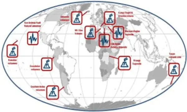
The Italian Space Agency (ASI) has launched on 22 March 2019 the PRISMA satellite carrying an hyperspectral sensor with a Ground Sampling Distance (GSD) of 30 m and covering the wavelength range from 400 nm to 2500 nm, with 10 nm spectral sampling. The launch was successful and the in-orbit commissioning has been completed, allowing PRISMA data to be accessible since May 2020 through the dedicated portal https://prisma.asi.it/. Data policy is based on a quasi-open and free access, with limitations on products per user quantities and on priorities for acquisition requests conflicts solving, to cope with the operational capabilities of the mission. Data policy allows commercial exploitation of value added product/services still delivering free of charge but forbids PRISMA original data redistribution.
Giovanni Rum & Ettore Lopinto
Italian Space Agency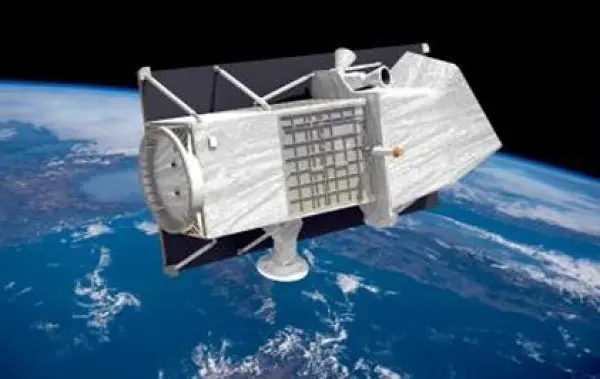
Italy is supporting GEO and UN-Habitat “Earth Observation Toolkit for Sustainable Cities and Human Settlements” Programme. The Programme participates to the EO4SDG Initiative and aims at developing a customizable and continually updated toolkit on the integration of Earth Observation and geospatial information into the urban monitoring and reporting processes on SDG targets and indicators based on inputs from UN Member States and cities. The CNR-IIA indicator estimation approach consists of deriving and updating, from Earth Observation data, some essential variables for the urban ecosystem: the spatial distribution and density of urban population and settlement maps. By integrating these essential variables with other domain- specific information i.e., the particle pollutant maps, specific urban resilience indicators and sub-indicators can be quantified. The case study focuses on updating the distribution map of the migrant population regularly residing in Bari and neighboring municipalities to monitor progress on the inclusiveness and sustainable urbanization targets of the SDG 11 of the UN 2030 Agenda.
Mariella Aquilino
CNR - Institute of Atmospheric Pollution Research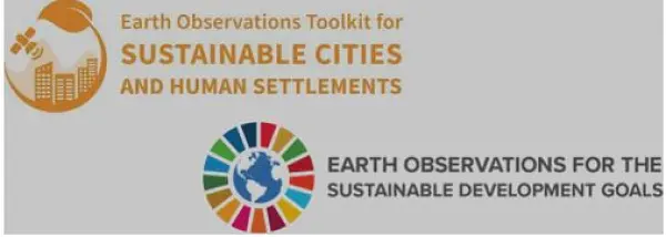
The Italian National Copernicus User Forum reflects the procedure of the Copernicus User Forum. It is composed by representatives of user communities belonging to public institution, public and private research bodies, industries and enterprises, covering all the Copernicus domains. Each User Community representative participating to the activities has to stimulate the community that represents, from central to local level, by promoting the use of Copernicus services and products and to link existing national EO initiatives.
Andrea Taramelli
Deputy Delegate to the Copernicus Committee
Another Italian contribution to GEOSS, namely to AfriGEOSS, is represented by the EC Project PanAfGeo (Phase II) PanAfGeo - Pan-African Support to the EuroGeoSurveys-Organisation of African Geological Surveys (EGS-OAGS Partnership), co-funded by DG-DEVCO, is a project which supports the training of geoscientific staff from African Geological Surveys through the development of an innovative training programme. The project aims to increase African-owned geological knowledge and skills for sustainable mineral exploitation and related infrastructures, and natural disaster prevention and mitigation. Specifically, PanAfGeo enhances the capacity and role of African national Geological Surveys; • Contributing to mineral resource assessments by national Geological Surveys in Africa; • Increasing the activity of national Geological Surveys in regional mapping and exploration to upgrade their geoscientific information base and mineral inventories; • Strengthening the level of geological knowledge and skills in national Geological Surveys through training; • Strengthening OAGS’ potential to meet the needs of the African continent. Capacity building is addressed to over 1,200 trainees (mostly African geologists) with the organization of 49 short- and medium-term trainings in several African countries focused on wide range of geosciences topics such as satellite imagery analysis, geological mapping through GIS techniques, geo-hazards geochemistry and analytical chemistry, economic geology, mineral exploration. ISPRA is currently involved in PanAfGeo in the coordination of the WP-F Georesources Governance & OAGS/GSOs Institutional Strengthening and also actively involved in WP-E Geohazards and Environmental Management of Mines in cooperation with LTG (leader), Council for Geosciences-South Africa (co-leader), PGI, GeoZS in the organization of 6 technical training sessions in several African countries.
Giuseppe Delmonaco
Geological Survey of Italy, Italian Institute for Environmental Protection and Research (ISPRA)
The Paris Agreement is one of the three GEO Engagement Priorities. To achieve its targets, systematic and long-term earth observation data are needed, in order to improve carbon budgets, reduce uncertainties of national inventories, and provide decision makers with reliable information. Italy, through CMCC, is supporting by co-chiaring the GEO Working group on climate change (as chair of the Sub-group 3 on Mitigation 2020-2022) that is aimed to develop and implement a comprehensive GEO climate change action strategy to advance the use of Earth observations in support of climate adaptation and mitigation. Furthermore, through a dedicated activity within EU funded project (VERIFY and CoCO2), CMCC (Italy) is engaged in creating the links between the observation-based system for monitoring and verification of greenhouse gases foreseen by the project and GEO, ensuring the coordination with global data synthesis efforts.
Lucia Perugini
Senior Scientiific Manager Fundation CMCC - Euro-Mediterranean Center on Climate Change
A private sector perspective: Downstream services by e-GEOS e-GEOS, an ASI (20%) / Telespazio (80%) company, , is a Global Leader in providing high technologic and innovative geoinformation services and platforms based on Artificial Intelligence and cloud technology with digital, fast and customized access covering all fields of the Geo-Spatial Information business. CLEOS, e-GEOS latest launch, is the Information cloud platform to unlock geoinformation value in AI-powered applications accessible through an enhanced user experience offering a direct market place access to customized products. e-GEOS offers a unique portfolio of application services, from data acquisition to the generation of analytics reports, also thanks to its radar capabilities and to the fast access to the superior monitoring capabilities of the COSMO-SkyMed constellation of first and second generation. e-GEOS has acquired also a leading position within the European Copernicus Program. e-GEOS application platforms include experienced and solid services for environmental protection, rush mapping in support to natural disaster management, specialized products for defense and intelligence, oil spill and ship detection, maritime surveillance and security, assets and critical infrastructures monitoring, landslides and ground subsidence analysis, thematic mapping for agriculture and forestry, climate change phenomena monitoring.
Fabio Volpe
Senior Scientist, e-GEOS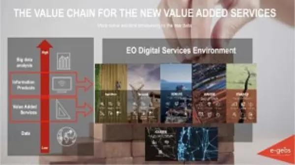
EuroGEO Showcases: Applications Powered by Europe (e-shape) is aimed to implement a coordinated and comprehensive EO data exploitation initiative through collaboration amongst the European GEO Members and Participating Organizations in order to accelerate the users' uptake of open EO data and information for the benefit of Europe. The general objectives are to set-up and promote a sustainable organization dedicated to users' uptake of European EO resources, building on Copernicus and GEOSS through the development of co-design pilots (i.e. application-oriented products, services or solutions) built on a user-centric approach and delivering economic, social and policy value to European citizens. CNR with several Italian partners (CMCC, Fondazione CIMA, INGV, ISPRA, PLANETEK, UNICAL) is leading a Showcase on Health Surveillance with four Pilots: (EO-based surveillance of mercury pollution, EO-based surveillance of POPs pollution, EO-based pollution-health risks profiling in the urban environment and EarlY WArning System for Mosquito-Borne Diseases) and participates to Pilots on myEcosystem and Disasters Resilience Showcases.
Nicola Pirrone & Sergio Cinnirella
Showcase Coordinators CNR - Institute of Atmospheric Pollution Research
Italy coordinates the LIFE NewLife4Drylands project (LIFE PRE/IT/000007; https://www.newlife4drylands.eu). It aims at the definition of a protocol for the use of Earth Observation to assess the effectiveness of Nature-Based-Solutions (NBS) for the restoration of degraded and desertified areas. NewLife4Drylands is coordinated by CNR (Institute of Atmospheric Pollution Research) and includes partners from Italy (CNR-Institute of Bioeconomy, ISPRA, University of Rome “La Sapienza”), Greece (Hellenic Society for the Protection of Nature, University of Crete) and Spain (CREAF). Restoration actions in six pilot sites in Greece (Nestos River, Mt. Asterousia), Italy (Palo Laziale, Alta Murgia) and Spain (El Bruc, Tifaracas) will be carried out for protocol design and evaluation. The protocol will consist of methodologies and best practices replicable and reusable on different contexts to support effective land management policies. The NewLife4Drylands protocol advances the use of remote-sensing and in-situ Earth Observation collected from disparate sources including GEOSS, as a resource for decision- making in land management applications. The protocol will be disseminated and exploited at national, European and global level including EuroGEO and GEO.
Paolo Mazzetti
NewLife4Drylands Project Coordinator CNR - Institute of Atmospheric Pollution Research
ERA-PLANET, the ‘European Network for Observing our Changing Planet’ (www.era- planet.eu), has been an ERANET Co-fund action under the EU Horizon 2020 framework programme, comprised of 35 partner organisations from 15 European countries, aiming at strengthening the European Research Area (ERA) in the domain of EO, in coherence with the European participation in the Group on Earth Observations (GEO) and the Copernicus programme of the European Union. Its goal was to bring together and strengthen the European, national and regional R&I programmes in the domain of EO, and develop a Transnational Environmental Observation System in support of European & international policies, through the integration of real- time monitoring data from various platforms, modelling tools and advanced global cyber- infrastructure for data sharing and interoperability. The four ERA-PLANET transnational projects were conclude on August 2021. More details at: SMURBS (www.smurbs.eu), GEO-Essential (www.geoessential.eu), IGOSP (www.igosp.eu) and iCUPE (www.atm.helsinki.fi/ icupe).
Nicola Pirrone
ERA-PLANET Coordinator & Research Director CNR - Institute of Atmospheric Pollution Research
A private sector perspective: Planetek Italia is an Italian Benefit Company established in 1994, which employs 100+ women and men, passionate and skilled in Geoinformatics, Space solutions, and Earth science. Planetek provides solutions to exploit the value of geospatial data through all phases of data life cycle from acquisition, storage, management up to analysis and sharing. The company operates in many application areas ranging from environmental and land monitoring to open-government and smart cities, and including defence and security, as well as Space exploration and EO satellite missions. Among its main activity areas, the development of software for the satellite on-board data and image processing leads to the creation of a new business model called SpaceEdgeTM. SpaceEdgeTM is a new concept of satellite as-a-service powered by an Artificial Intelligence (AI) enhanced processing framework embarked on satellites, which makes available in- orbit payloads, resources, and services on-demand: services include EO data acquisition, processing, actionable information extraction, downlink, and distribution. Information detected in Space is then transferred back to the Ground as notifications and alerts or directly exploited on-board in autonomous decision workflows. Useless data and information non-relevant to the application’s workflow can be discarded, saving memory, bandwidth and thus increasing the efficiency and quality of automated pipelines too. The fields of application of on-board processing to reduce information latency are numerous, and will address GEO's priority engagement areas including the United Nations 2030 Agenda for Sustainable Development, the Paris Agreement, and the Sendai Framework for Disaster Risk Reduction.
Giovanni Sylos Labini
CEO, Planetek Italia s.r.l.
-

Japan
The Biological Information System for Marine Life (BISMaL) , which has been developed by the Japan Agency for Marine‐Earth Science and Technology (JAMSTEC),has published 48 datasets (total of 2.3 million biological observations) from scientific researches by JAMSTEC, universities, research institutes and citizen science. Integrated into the Ocean Biographic Information System(OBIS), it plays a key role as the primary information source in the Northwest Pacific region, and has been used in the Asia Pacific Marine Biodiversity Observation Network(AP-MBON) and contributed to the Intergovernmental Science-Policy Platform on Biology and Ecosystem Services(IPBES).
ANDO Kentaro
Director in charge of International Study in the Western Pacific, Research Institute for Global Change/JAMSTEC
National Research Institute for Earth Science and Disaster Resilience (NIED) has integrated observation networks, The Monitoring of Waves on Land and Seafloor (MOWLAS), which consist of 2,100 stations to provide comprehensive, accurate, and rapid observation and monitoring of earthquake, tsunami, and volcano activity throughout Japan and its offshore areas. The application of real-time observations and processing of MOWLAS data has contributed to disaster mitigation through its earthquake early warning and tsunami warning.

JAXA is fully committed with addressing GEO priorities by sharing datasets and analyzed products to promote utilization for understanding, planning and decision making. In collaboration with UNEP, the Global Mangrove Watch Dataset provides evidence to respond to mitigation of the Climate Change and preservation of Biodiversity.
TERADA Koji
Vice President, Director General, Space Technology Directorate I, Japan Aerospace Exploration Agency (JAXA)
-

Mercator Ocean International
GEO’s Blue Planet Initiative aims to ensure the sustained development and use of ocean and coastal observations for the benefit of society. One of our main activities this year, led by GEO Blue Planet’s EU Office has been centred on monitoring and addressing the challenges of marine litter, a worsening global problem. Advocating, engaging and cooperating with as many stakeholders as possible is a prerequisite for progress and an underlying principle of GEO Blue Planet. We were present at the 2022 place to be: the UN Ocean Conference in Lisbon. We made GEO very visible with our official side-event on integrating marine litter monitoring to inform action, which was a real success. We welcomed over 80 participants from 23 countries, advocating the necessity of a global sustained Integrated Marine Debris Observing System (IMDOS) and its links to the UNEP Global Partnership on Marine Litter. The proceedings from this event will inform the proposed IMDOS Terms of Reference and interim Steering Committee, who will work together with the new IMDOS project coordinator to develop the IMDOS strategy and implementation plan. This momentum will continue during our 5th Symposium in Accra, Ghana during which we will improve GEO Blue Planet’s engagement with African nations to expand the Earth Observation community of practice, strengthen local capacity and provide access to resources, tools and services. We are expecting about 200 participants from various stakeholder groups and on of the plenaries is dedicated to ecosystem conservation, which explores microplastics, and the potential role for satellite data.
Audrey Hasson
GEO Blue Planet EU Coordinator, Mercator Ocean International
-
Namibia
In recent years, with more open data platforms such as GEO and tools available to store and process satellite imagery, EO data have become widely accessible and usable in Namibia, especially for research and decision making related to climate change. Furthermore, encouraged by GEO and the GEO Member Community, Namibia as a country has developed the National Space Science and Technology Policy of 2021, aimed to guide the use of space resources to contribute towards the socio-economic growth and development of Namibia.
Dr Lisho MUNDIA
Director of Research and Innovation, Ministry of Higher Education, Technology and Innovation
-

Netherlands
Space applications for society, science and economy The Netherlands actively stimulates the development and use of services based on satellite data, to bring the benefits of space to society, science and economy.
Harm van de Wetering
Director, GEO Principal for the Netherlands Netherlands Space Office (NSO)
The air we breathe The TROPOMI satellite instrument provides timely images of air quality and climate parameters for every place of the Earth. Already five years, with TROPOMI we can see which policy measures are effective for improving the air quality.
Pepijn Veefkind
principal scientist TROPOMI Royal Netherlands Meteorological Institute (KNMI)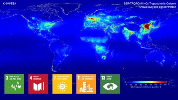
Towards a better food security End 2021, over 4 million smallholder farmers in Africa and Asia have benefitted from products and services based on open and free satellite data in the Geodata for Agriculture and Water (G4AW) programme. The G4AW programme aims to reach 4.5 million food producers by summer 2023. Geodata-based services assist farmers and pastoralists in increasing their productivity and adapting to climate change.
Chris de Nie
Department of Inclusive Green Growth Ministry of Foreign Affairs, the Netherlands
The time for climate action is now. We can turn the tide if we take fast, decisive action. The world needs to adapt to what is coming and do everything possible to immediately reduce emissions. Availability and accessibility of reliable data is crucial in this endeavor. Earth observation plays an important role. It increases our understanding of the consequences of climate change, and can thereby be a powerful tool for policymakers across the world.
Jaime de Bourbon de Parme
Climate Envoy Kingdom of the Netherlands
More effective use of water in agriculture on a global scale An increasing number of countries does not have enough water to grow food for their growing population. More crop per drop is needed. This is why we support the FAO WaPOR project that has the aim to improve land and water productivity in the face of climate change. In 2022 the decision is made to make the WaPOR data available at a global scale.
Aart van der Horst
Department of Inclusive Green Growth Ministry of Foreign Affairs, the Netherlands
Netherlands Space Solutions for Climate Adaption and Mitigation Dutch companies and institutions develop new innovative solutions using satellite data that contribute to the provision of information to facilitate climate adaptation and mitigation.
Kathelijne Beenen
Advisor Satellite Applications Netherlands Space Office (NSO)
Space solutions contribute to peace and security The Dutch initiated the Water, Peace and Security initiative - a broad coalition of international partners coordinated by IHE Delft Institute for Water Education - designed innovative tools and services identifying water-related security risks to help mobilize stakeholders, build capacity and facilitate action. Understand - mobilize - learn - facilitate - act!
Henk Ovink
Special Envoy for International Water Affairs Kingdom of the Netherlands
Objective information from satellite in support of sustainable sourcing landscapes Geodata are used by the Verified Sourcing Areas (VSA) of the Sustainable Trade Initiative (IDH) and partners to verify outcomes at landscape level, such as deforestation rates, included in Produce, Protect, Include compacts. Doing this, spatial data are used by local stakeholders, including government and private sector, driving sustainable production and international partners, like retailers and brands, for sustainable sourcing.
Omer van Renterghem
Department of Inclusive Green Growth Ministry of Foreign Affairs, the Netherlands
Tackle global CO2 while enhancing farmers’ businesses using satellite data Rabobank launches an agroforestry initiative aimed at sequestering CO2 while enhancing smallholder farmer practices in developing countries. This online platform connects large corporates looking to offset their unavoidable emissions with smallholder farmers who are sequestering carbon through agroforestry. The initiative also helps farmers improve their business model by transforming monoculture farming into future-proof agriculture.
Jelmer van de Mortel
Innovation lead Wholesale and Rural | Head of Acorn - Rabobank
Space for global development: education and capacity building We are here to identify and understand vulnerability – and to convert it into resilience by developing, applying and sharing geospatial impact-driven solutions We educate our students to be professionals, capable of acquiring knowledge and translating this into practical applications for solving real-world problems.
Prof. dr. Freek van der Meer
Dean Faculty ITC University of Twente
The role of Citizen Science Our Action Research on Citizen Science helps GEO achieve impact related to sustainable development, elevating the value of citizen science communities and data from local to global scales.
Dr. Uta Wehn
IHE Delft Institute for Water Education
-

Sustaining Arctic Observing Networks
The rapid ongoing changes in the Arctic present an urgent need to better observe, characterize and quantify processes and properties of the Arctic system. Full integration of ground-based and satellite observing systems is fundamental to achieving this overarching target. ArcticGEOSS will offer policy-relevant services as the link from the observing system to societal benefits. The need for this link has been identified in the International Arctic Observations Assessment Framework (IAOAF, 2017).
Jan Rene Larsen
SAON Secretariat -
Sweden
Global Action for Local Impact is really something where GEO can contribute, and the continued work that GEO is doing in order to improve the availability, access and use of open Earth Observations is therefore of utmost importance. The development and implementation of the Work Programme 2023-2025 will be instrumental in providing better insights and evidence for policy development and decision making, which is expected to lead to improved local impact over time, not at least when it comes into the field of climate adaptation.
Håkan Wirtén
Director General, SMHI, (Swedish GEO Principal)
Global Action for Local Impact is required in order to accelerate the implantation of Agenda 2030, the Paris Agreement on Climate Change and the Sendai Framework for Disaster Risk Reduction. In this context, GEO has been contributing and will continue its efforts to improve the availability, access and use of open Earth Observations data. GEO Work Programme 2023–2025 will continue the work for enhanced delivery and impact of EOdata. Well received objectives of the Work Programme are the greater collaboration and integration of Programme activities, stronger emphasis on open knowledge and more specific identification of outputs and intended actual users.
Cristina Alionte Eklund
International Relations Manager, SMHI (Swedish new GEO Alternate)
The Swedish Space Agency is together with Luleå Technical University, Research Institutes of Sweden and AI Sweden developing the Swedish Space Data Lab, to promote innovation, method development and promote the use of AI with Earth Observation data. The platform that is the Collaborative Ground Segment for Copernicus in Sweden is further developed to Digital Earth Sweden, to further enhance the Swedish capacity of processing and analyzing earth observation data. Digital Earth Sweden is based on the Open Data Cube and the OpenEO API. All developments are provided as Open Source as part of the capacity building effort of the lab.
Dr. Tobias Edman
Head of Innovation and Public Benefit at the Swedish National Space Agency (SNSA)
Using Earth Observations big data and AI, KTH Royal Institute of Technology has developed innovative methods and applications to support sustainable and resilient urban planning, and early detection and near real-time monitoring of wildfires. The EO-based wildfire applications developed by the KTH team can be used by fire-fighting authorities for effective emergency management and decision support during and after wildfires. The EO&AI-based method developed by KTH produced high-quality urban mapping and change detection results for 60 cities around the globe. Using EO-derived urban data in the EO4SDG11 Toolkit, KTH developed a Google Earth Engine app for automatic city definition and calculation of SDG 11.3.1 “Land Use Efficiency” core and secondary indicators for any city in the world. The SDG11.3.1 Land Use Efficiency app is nominated for the GEO SDG 2022 award. The research is part of the EO-AI4GlobalChange project, funded by the GEO-Google Earth Engine Program and the Digital Futures of Sweden, with close collaborations with stakeholders including the City of Stockholm, UN Habitat, Swedish Civil Contingencies Agency (MSB) and British Columbia Wildfire Services. As member of the EO4SDG Toolkit Steering Committee member at GEO, KTH has played an important role in the EO4SDG11 Toolkit development. Testimonial on the SDG11.3.1 app https://eo4sdg11.users.earthengine.app/view/sdg-1131-indicator Dennis Mwaniki, Spatial Data Expert, & Robert Ndugwa, Head, Data & Analytics Section UN-Habitat: The innovative tool not only provides an easy way to extract information from EO data and compute SDG 11.3.1 core and secondary indicators following the global indicator methodology (including adopting the harmonized DEGURBA methodology), but also gives the user the power to input their own data and adjust boundaries where inconsistencies and/or misclassification noted. This flexibility, and the simplicity with which the tool enables users to visualize and interact with the diverse archive of EO products makes it an invaluable resource that will significantly improve data production at the local level and enhance SDG 11.3.1 monitoring at the global scale. Testimonial on the Wildfire app https://omegazhangpzh.users.earthengine.app/view/wildfire-monitor-v7 Justin Nicholas, Wildfire Technician, British Columbia Wildfire Services: We are encouraged by the excellent data products and visualization tools produced (by KTH). Overall, we are very excited with the prospect of near-real time processing of multiple satellite dataset to compile reliable fire progression maps as quickly as possible and we are very impressed with the high quality of the products generated. This technology could have significant positive economic and societal impacts in British Columbia.
Prof. Yifang Ban
KTH (Royal Institute of Technology Sweden)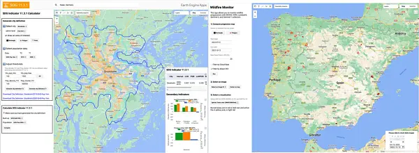
-

United Kingdom
This year’s GEO Week comes as I step down from the role of UK Principal to GEO. I am moving on from the Defra Chief Scientific Advisers Office to work on new environmental science challenges. In my time as UK Principal, I have seen GEO’s work on climate action grow steadily, from the establishment of the Climate Change Working Group to its active engagement with the UNFCCC Research and Systematic Observations team and interventions on the panel for the “Earth Information Day for Climate Action – Perspectives from the UK Presidency” event at COP26. I have welcomed the increasing engagement of the UK research base, including more recently from the private sector, in GEO work programme initiatives. I am therefore pleased to have been able to confirm the UK’s ongoing financial and technical support to the work of GEO. I am confident that the UK’s engagement with GEO will continue to go from strength to strength through its strong network of committed stakeholders, and I look forward to the further realisation of GEO’s mission in its Post-2025 era.
Dr. Robert Bradburne
Deputy Chief Scientific Adviser, Defra and UK Principal to GEO
The UK community of research experts have continued to be engaged strongly with the GEO programme of activities, supported by UK government funding mechanisms including notable grants from United Kingdom Research and Innovation (UKRI) in this year and from government agencies noted in this statement. International collaborations, such as those initiated through GEO, are very important for UK scientists. We are particularly focussed on trusted services and data to meet the GEO challenges and to exploring the long-term development of co-operating systems which make a difference to policies and people. Climate science and carbon mitigation are critical challenges for UK and world research. The GEO work around forestry and agriculture is a particular interest and value to the UK science base, particularly the linkages between net carbon emissions in the Paris Agreement context with ecosystem health and food security. Also, ongoing efforts to respond to the UN ocean decade are to be supported. The GEO Climate Change Working Group has an important role to play. We also strongly endorse efforts to respond to hazards and disasters in a more resilient and timely fashion. GEO offers mechanisms to bring together international bodies and further engagement between observational, research, meteorological and service delivery agencies will benefit the advances that we all want to achieve.
Professor John Remedios
Executive Director of the National Centre for Earth Observation
The global geospatial and Earth observations communities are inextricably linked. We must do more together to understand our changing planet, to help our international system make more informed decisions about how to respond to climate challenges, and to help governments and societies mitigate and adapt. We were so pleased to have Yana, and some of the wider UK GEO community, present at the Cambridge Conference earlier this year, and to work together to bring GEO into our conversations with the UN Committee of Experts on Global Geospatial Information Management (UN-GGIM) in August. Bringing National Mapping and Geospatial Agencies together with the EO experts can only strengthen our global response to these pressing issues – working together, GEO can unlock EO.
David Henderson
Chief Geospatial Officer, Ordnance Survey
-

United States
