China
- Home/
- Partners/
- Member Governments/
- China


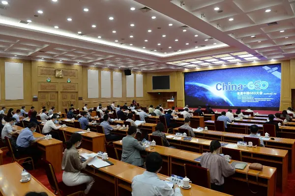
United at the first China GEO Conference, China GEO community further strengthens in-depth research to address common global challenges and carry out cooperation on food security early warning, ecological environment monitoring and climate change response. We hope to help building a Community with a Shared Future for Mankind through a joint effort.
Established in 2016, Collaborative network on Disaster Data Response (CDDR) is responsible for coordinating the provision of Chinese high-resolution satellite data and disaster analysis products to disaster-affected countries. By October 2022, the CDDR mechanism had provided information services to cope with 35 major disaster emergency events such as earthquakes, volcanoes, floods, storm surges, wild fire and explosions in 25 countries.
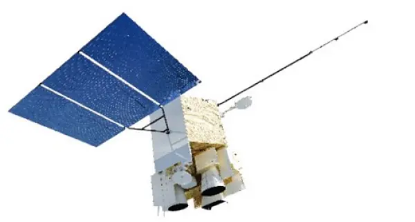
Two new members of the Fengyun satellite family, Fengyun 3E and Fengyun 4B, were put into operation on June 1, 2022. We provide various forms of data sharing, downloading and processing services. Applications using Fengyun satellite data, especially those aiming at GEO priorities including sustainable development, climate change, and disaster resilience, are very welcome.
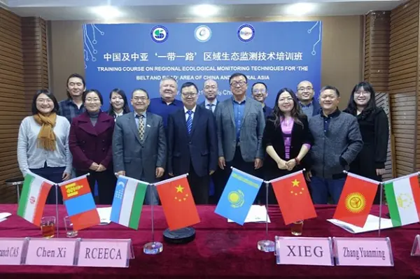
Under the GEO Community Activity “In-Situ Observations and Applications for Typical Ecosystem Status of China and Central-Asia”, a 12-day training workshop on ecosystem monitoring in China and Central Asia was organized with 30 participants from 6 countries, which enhanced monitoring capacity of technicians and research staff from the Central Asia for their better environment status review.
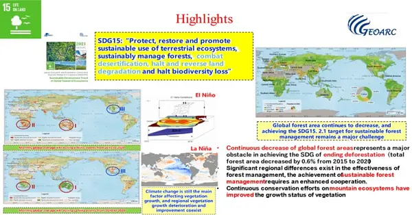
From 2020 to 2022, GEOARC advocated analysis-ready open data by integrating multiple EO data to generate common products. GEOARC released 4 annual reports and 41 datasets for ecosystem and environmental monitoring to support the GEO priorities, organized more than 10 task group sectorial meetings in AOGEO Symposium, GEO Week side events, training and other activities.
The Zero Hunger Goal is an important part of UN SDGs and an important mission of GEO. The global agricultural remote sensing monitoring cloud service platform, CropWatch was developed since 1998. Over the past 20 years, CropWatch has been providing public information sharing services on agricultural monitoring, enhancing agricultural capacity building in developing countries, and increasing the transparency of global agricultural information. CropWatch will follow GEO's strategic vision to further advance the accessibility and EO application to decision-making for the benefit of humankind.
Encouraged by GEO and the GEO Member Community, we have conducted remote sensing monitoring of habitat suitability and dynamic forecasting of occurrence risk for globally significant migratory and epidemic crop pests and diseases (desert locust, fall armyworm, wheat rust, etc.), and published scientific reports. The outcomes have been adopted, shared, and released more than 100 times by domestic and international government departments, organizations, institutions, and industrial enterprises. With these services, we have promoted the practical application of products and contributed to the achievement of SDG and disaster risk reduction objectives.

In June 2022, supported by GEO and AOGEO community, the 5th AOGEO Workshop was held online with the adoption of 2022 AOGEO Announcement. More than 130 delegates from 16 countries attended this workshop online and over 500 people watched the broadcast. The theme of this year is “Harmony and Empowerment: Accelerate Action and Development”. AOGEO will accelerate action to promote synergistic development and regional empowerment in response to regional needs.

On September 20, China announced to make the data acquired by the Sustainable Development Science Satellite (SDGSAT-1) launched by China in November last year available globally to assist countries in sustainable development research and decision-making. China released the Report on Big Earth Data in Support of the Sustainable Development Goals (2022), which studies the interactions among SDG indicators and their integrated evaluations, providing scientific evidences for quantitative and systematic evaluating the implementation of SDGs at national, regional and global level.

I believe that in the future, GEO will further leverage the advantages of inter-governmental and international organizations to promote the connectivity of Earth observation infrastructure, the smooth flow of spatial and geographic information elements, the harmonization of concepts and philosophies among countries with a value orientation of inclusiveness and mutual learning, and the heart-to-heart bond among the international general public, aiming at jointly boosting stronger, greener, and more sustainable future shared by all.

From May 29 to 31, we successfully held the 6th AOGEO Workshop in Macau, China. Under the theme ‘Demand-driven Advancements in Earth Observation Technology and Application’, the Workshop attracted more than 80 offline participants from 18 countries and 6700 participants online among which heated discussions were delivered covering various region-specific topics including capacity building, youth’s participation in GEO, open data and open knowledge, etc. As the GEO co-chair representing AOGEO and developing countries, China will continue dedicating efforts into regional Earth observation advancement in pursuit of a balanced and mutual development to close digital and information gaps.

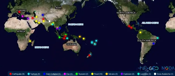
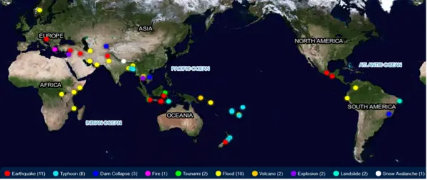
GEO China initiated the Collaborative Network of Disaster Data Response (CDDR) in 2016 in response to the GEO’s call for global coordinated disaster risk reduction. By October, 2023, the CDDR mechanism has been triggered 47 times in total by global major disasters including earthquakes, volcano eruption, floods, tsunami, typhoon, wild fires, explosion, avalanche, among others in 33 countries. Satellite data, images, disaster analysis, rapid mapping and related services sourced from more than 30 public and commercial Chinese satellites were provided to affected countries for free. In the future, China welcomes contributions from more countries and institutions to CDDR, enabling countries with insufficient capacity in disaster risk reduction to benefit from Earth observations.
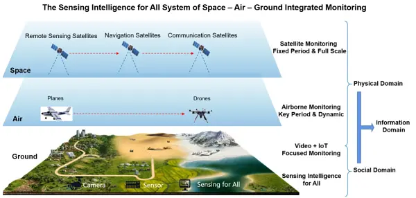
Under the direction of GEO China Secretariat (NRSCC), targeting the GEO Engagement Priority of Resilient City and Human Settlement, GEO China Expert Working Group closely keeps pace with GEO’s advancement. Together with multi-disciplinary talents applying Earth observations, we are building an integrated space-air-ground monitoring system, leveraging the sensing intelligence for all in our cities and human settlement. We will continue transforming scientific research into applicable and accessible EO services and products to secure a sustainable and resilient future in support for the New Urban Agenda along with other global initiatives.
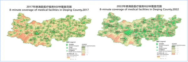
Based on long time-series Earth observation satellite data and socio-economic data, we have developed SDGs indicators and local dynamic monitoring and evaluation platform, aiming at analyzing transformation between SDGs indicators and geoinformation and calculating SDGs indicators to support dynamic and normalized monitoring. The application case of this platform was delivered in Deqing, China, and exhibited an 8-minute coverage of medical facilities. The case was also presented at the UN Summit on Sustainable Development Goals in Sept., 2023.
Initiated by National Remote Sensing Center of China in 2012, Global Ecosystem and Environment Observation Analysis Research Cooperation (GEOARC) has been consecutively releasing analytical reports and datasets for more than 10 years, covering a wide range of topics such as water, cities, climate change, natural disasters, crop, cryosphere and so on, in which EO tools are used to support decision making, capacity building and scientific research. So far, GEOARC has published 31 annual reports and 115 open access datasets in total.
On February 6, 2023, Earthquakes occurred in southern Turkey within 10 hours, causing heavy casualties, serious damage to social and economic facilities in 11 provinces of Turkey and parts of Syria. UNOSAT has collaborated with Wuhan University for the disaster loss mapping. Night-time imagery from Chinese satellites and U.S. satellites were combined to track the electricity loss and recovery in the disaster-affected cities.

