Greece
- Home/
- Partners/
- Member Governments/
- Greece

Greece, consistently dedicated to promoting the use of Earth observation, is co-organizing this year, together with the European Commission, the 2022 edition of the EuroGEO workshop “Towards an integrated and convergent EuroGEO”. The workshop will take place as a physical event in https://www.electrahotels.gr/hotels/electra-palace-athens/Athens, Greece, from 7 to 9 December 2022. The local organization is overtaken by the General Secretariat for Research and Innovation of the Hellenic Ministry of Development and Investments, and the Greek GEO Office. During the workshop, we will be, among others, offering networking opportunities to the participants, look for synergies across different projects and initiatives, and identify opportunities to work under a nexus approach.
The prominent position of Earth Observation, Satellite Imagery and Geo-spatial Data in Official Statistics is indisputable. European Statisticians had already ratified this fact in 2021 DGINS Conference. The recent Europe-wide Censuses results will be delivered at a 1km2 grid, proving our strong belief in the need for geospatial disaggregation and enabling integration of EO in socio-economic data. The Hellenic Statistical Authority (ELSTAT) carries this discussion further through the Memorandum of Cooperation with the Greek GEO Office and stands ready to steer projects as data provider, while exploring possibilities of using EO data in Official Statistics.
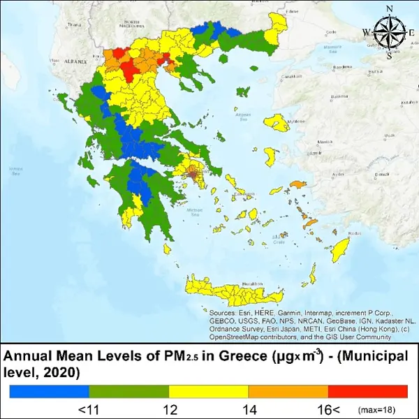
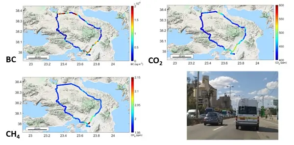
Eastern Mediterranean and Middle East (EMME) is a crossroad of pollutants from Europe, Africa, Asia, and America. Additionally, EMME is an important climatic hot spot region with atmospheric temperature increasing faster than the world mean. Regarding atmospheric health parameters, the levels of ozone and particulate matter (PM) in the EMME often exceed the limits set by EU and WHO with significant health impacts on the population. On the other hand, EMME is an under sampled area in terms of continuous monitoring of greenhouse gases and short-lived climatic sensitive parameters (i.e. ozone, aerosols and clouds). During the last few years, Greece, as a member of the European Infrastructures ACTRIS and ICOS and in order to fill these gaps, initiated two important observation projects named PANACEA and CLIMPACT, dealing with short-lived climatic sensitive parameters and greenhouse gases, respectively. It is expected that the phase two of these projects in the coming years, will reinforce the role of the Greek community in the European Observation capacity environment and will provide new data to help decision makers to design a sustainable future.
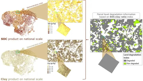
To safeguard natural capital of soils, in a continuously volatile landscape of reduced resources and environmental changes and pave the way for the development of evidence-based conservation recommendations for policies and sustainable services for relevant economic operators, it is essential to improve capacities for soil health monitoring by adopting multidimensional and integrated approaches. In this context the Interbalkan Environment Centre in collaboration with the Aristotle University of Thessaloniki supports the evolution of EO-based soil mapping tools via the synergistic use of AI algorithms, process-based simulations, and climatic projections, to generate very high spatial resolution and enhanced spatial soil health indicators. In 2022, within the framework of ESA WORLDSOILS project and H2020 EIFFEL we have analysed petabytes of Sentinel-2 data to feed interpretable AI algorithms in support of the National Paying agencies by providing them annual maps of soil carbon sequestration over croplands. This fully aligns with the objectives of SDG 15.3.
The SDG Decade of Action necessitates novel and systemic way of thinking. The Sustainable Development Solutions Network calls all hands on deck in this endeavor. Thus, we have established a working relationship with the Greek GEO Office in order to leverage the EO potential regarding the SDGs, beyond monitoring Indicators and into supporting Targets through their localization, an integral part of our agenda. We strongly advocate for the integration of EO and socio-economic data, to our delight one of the pillars of the new GEO Strategy, and are looking optimistically and deliberately ahead to co-design the concept of Earth Intelligence to the benefit of all.
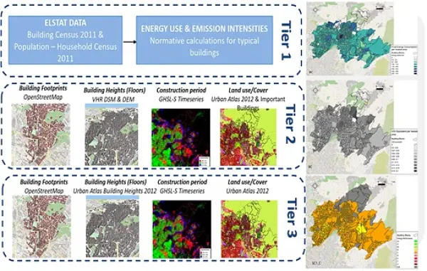
Energy used for buildings construction and operation accounts for about 34% of the total global final energy consumption and contributes 37% to global GHG emissions. As a result, the buildings sector is at the center stage of international, EU and national efforts for improving energy efficiency and curbing emissions in order to fulfil the targets of the UN Paris Agreement on climate change. Bottom-up building stock models (BSM) utilize building typologies to handle the diversity of the thousands (or even millions) of existing buildings to quantify operational energy use and emissions, model their future evolution, and assess different renovation scenarios in order to transform buildings from being part of the problem to becoming part of the solution. However, accessing detailed data on the built environment remains a challenge. During a pilot study in Athens, GEO data proved an asset for providing up-to-date information about existing buildings with sufficient spatial analysis suitable for local planning, identifying building geometrical characteristics (e.g., building height, footprint), by complementing and updating census data from the Hellenic statistical authority (ELSTAT) using three different approaches (Tiers). The BSM utilized the Hellenic TABULA typology with energy and carbon intensities along with input data from the three Tiers to estimate the energy performance and GHG emissions and quantify savings under different deep renovation scenarios for municipal and regional building stocks. GEO data also facilitates our work on urban scale sustainability assessment and rating systems that are being developed to support municipalities, local authorities and other stakeholders to assess renovation and decarbonization plans of the built environment. The information can expedite the audit process of neighborhoods and cities, to collect data for quantifying sustainability criteria and key performance indicators like land use, open and green cover for soil sealing.
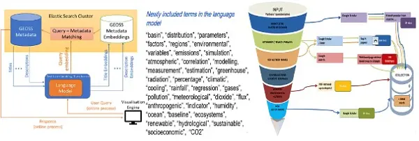
GEO and Earth Observation, being part of Big Data, has embraced AI as a tool to extract added value from the extraordinary proliferation of data coming from a wide array of EO platforms, from thousands of satellite images to IoT in situ sensors. Our company, LIBRA AI, in unison with the EO community, has worked towards exploiting another AI component, the Large Language Model. An out-of-the-box LLM through a vast EO corpus has been rendered Climate Change specific in order to, among others, enhance cognitive search. Could we leverage the pipeline and know-how to create a “GEO Large Language Model”?