GEO Night Light Supports Humanitarian Affairs
Natural disasters and armed conflicts are two major causes of humanitarian disasters which hinder progress of Sustainable Development Goals (SDGs) including SDG 11.5 and SDG 16.1. Particularly, SDG 11.5 is* “By 2030, significantly reduce the number of deaths and the number of people affected and substantially decrease the direct economic losses relative to global gross domestic product caused by disasters, including water-related disasters, with a focus on protecting the poor and people in vulnerable situations”. SDG 16.1 is “Significantly reduce all forms of violence and related death rates everywhere”. *
Night-time light remote sensing, which records artificial light at night (ALAN), provides a unique perspective on the human activities, socioeconomic dynamics, and thus it has been recently applied in tracking humanitarian disasters. Night-time Light Remote Sensing for Sustainable Development, also known as GEO Night Light, is a GEO Pilot Initiative which aims to use night-time light remote sensing to track progress of several SDGs with special attention on humanitarian disasters. Prof. Xi Li from Wuhan University, China and Dr. Einar Bjorgo from United Nations Satellite Centre (UNOSAT) are lead and co-lead of this Initiative, respectively.
With support from GEO China Secretariat, GEO Night Light team has delivered more than ten products to international users including United Nations Office for the Coordination of Humanitarian Affairs (UNOCHA), United Nations High Commissioner for Refugees (UNHCR), International Committee of the Red Cross (ICRC), Office of the United Nations High Commissioner for Human Rights (OHCHR) and the World Food Programme (WFP), with a part of the products open to public. The followings are some of the showcases.
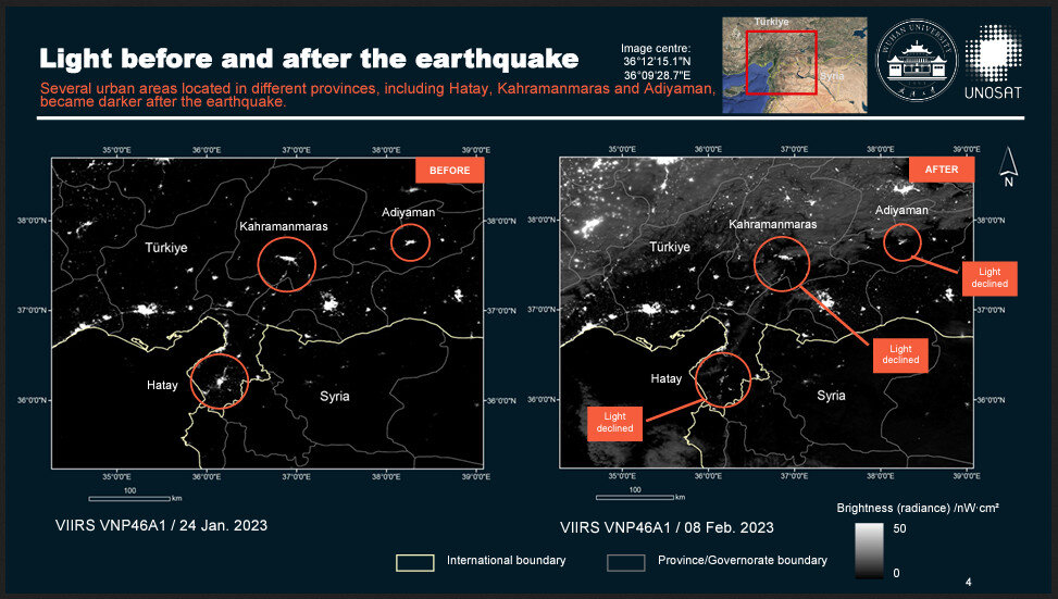
On 6 February 2023, the International Federation of Red Cross and Red Crescent Societies (IFRC) embarked on the UNOSAT's Emergency Mapping service over both Syria and Türkiye. As a part of the emergency mapping, the GEO Night Light team has used night-time light remote sensing imagery, from both NASA and Chinese space agencies, to evaluate power outage and recovery after the earthquake. Two evaluation reports (https://unosat.org/products/3565, https://unosat.org/products/3497) were delivered to several UN organizations, supporting the humanitarian relief after the earthquake. Particularly, the products were cited in UNOCHA’s first evaluation report on the earthquake (https://reliefweb.int/report/turkiye/turkiye-2023-earthquakes-situation-report-no-1-16-february-2023), and cited by UNHCR (https://data.unhcr.org/en/documents/download/98891). The reports were also utilized by the International Charter Space and Major Disasters and the Global Disaster Alert and Coordination System.
In April 2023, military conflict broke out in Sudan which has resulted severe humanitarian disasters. Requested by UNOCHA, GEO Night Light has released an evaluation report using night-time light remote sensing for Sudan Conflict in June 2023. The report was shared in UNOSAT’s website. The report was also delivered to ICRC as its SITREP which supported its humanitarian work.
In June 2023, OHCHR requested UNOSAT to assess the humanitarian situation in Tigray, Ethiopia which has suffered from armed conflict since 2020. GEO Night Light has released an evaluation report using night-time light imagery to assess the humanitarian condition in Tigray, and the report was delivered to OHCHR in September 2023 and also shared online.
Satellite-observed night-time light provides synoptic view on the human activities and power supply, which will help humanitarian organizations more efficiently as more satellites are to be launched in future. Currently, GEO Night Light plans to expand its network of participants, which will connect more UN organizations, research organization and stakeholders, and monitoring light pollution will be another focus in the Initiative.
The above work by GEO Night Light will be summarized as a talk titled Humanitarian mapping using night-time light imageryby Xi Li in the Flash Talks session of GEO Week 2023 in Cape Town.