Bridging the heat resilience gap: How to empower urban decision-makers

Extreme heat is a daily reality for many urban residents, but developing cost-effective resilience strategies is often a timely, expensive process, while citizens need immediate solutions.
Martyn Clark, GEO's Urban Resilience Coordinator, discussed this issue – and how GEO can bridge the gap between heat monitoring and decision-making - at a recent webinar organised by C40 Cities, through their Cool Cities Network.
Overcoming complexity
There is no universal metric to measure extreme heat and its impacts. Extreme heat is often defined by a range of metrics and indicators including temperature, humidity, wind and solar radiation. These all have a bearing on how heat is experienced by humans.
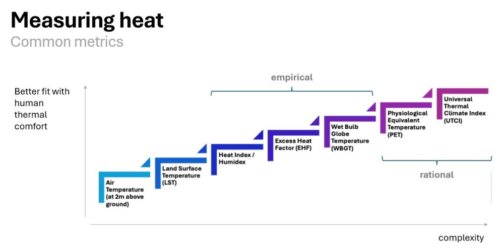
There isn’t necessarily a “one-size fits all” heat metric for all situations. Instead, the most appropriate measure often depends on the specific requirements of the application, available data, level of resources and capacity for analysis, and the target audience. Source: Martyn Clark, 2024.
Urban heat mapping is further complicated by the spatial and temporal variability of urban heat and patterns of exposure and vulnerability.
The form and function of a city influences the scale and nature of heat as a hazard, altering the physical and thermal characteristics of cities. The conditions in which people live and work and move around cities all determine levels of exposure to heat risk, whilst socio-economic characteristics may determine how sensitive certain groups or individuals are to heat.
Developing impactful urban heat solutions requires translating local heat stress metrics into actionable insights. In his presentation, Martyn recommended that cities:
- Select a suitable heat stress metric based on their budget, audience and available data;
- Develop heat-risk maps that incorporate local climate, urban morphology, and socioeconomic factors to determine relative levels of risk across the city as a basis for prioritizing when and where to act; and
- Ensure that heat risk maps and information are clear, understandable and usable for policymakers.
These actions must be urgently taken to save lives, money and resources in urban areas with extreme heat. Yet for many cities (often those most impacted by climate change), the cost of acquiring, analysing and translating data into policy actions and investments is an access barrier to successful heat management.
GEO’s solution
GEO will tackle these challenges with the launch of the Global Heat Resilience Service (GHRS), which will leverage geospatial observations, AI and cloud computing to provide in-depth heat metrics and solutions to every urban area on Earth.
As a policy tool, GHRS will empower leaders to create science-based heat plans that account for people's lived experiences. For researchers, this will provide an unprecedented way to compare and assess global urban heat.