EuropeMember since 16 Feb 2005

Germany
GEO Principals

Tobias Fuchs
GEO Principal AlternateDWD
Anne-Sophie Dörfel
GEO Principal AlternateBMVFocal Points

Programme Board representation
Adrian Strauch
Germany
Katrin Koch
GermanyGEO Engagement and Contributions
Engagement History with GEO
Germany is a founding member of GEO and continues to play an active role in GEO governance. It is one of GEO’s key donors and has supported the GEO Trust Fund through voluntary annual contributions. Germany has also provided substantial extrabudgetary funding for GEOGLAM initiatives, support for GEO-BON and for hosting the GEO-LDN secretariat at the German Corporation for International Cooperation (GIZ) in Bonn, Germany.
The lead ministry that engages with GEO from Germany is the Federal Ministry of Transport (BMV), with the German Space Agency at DLR serving as the focal point and the coordinator of the National GEO.
German participation in GEO involves multiple federal agencies, including:
- German Meteorological Service (DWD)
- German Corporation for International Cooperation (GIZ)
- Federal Agency for Cartography and Geodesy (BKG)
- Federal Institute of Hydrology (BfG)
- Federal Institute for Geosciences and Natural Resources (BGR)
- Federal Office of Civil Protection and Disaster Assistance (BBK)
- Federal Environment Agency (UBA)
- Julius Kühn Institute (JKI)
- Helmholtz Centre for Geosciences (GFZ)
- Helmholtz Centre for Environmental Research (UFZ)
- German Aerospace Center (DLR)
Participation in GEO Work Programme
Germany actively participates in several GEO Work Programme activities, with a focus on water and land sustainability, disaster risk reduction, ecosystems, biodiversity and carbon management, and climate, energy and urbanisation.
The country plays a pivotal role in supporting the GEO-LDN Flagship, providing both financial and technical contributions and hosting the GEO-LDN Secretariat at the GIZ. GEO-LDN aims to improve land degradation monitoring and mapping. The ultimate goal of GEO-LDN is to reduce the extent of degraded land and support the achievement of land degradation neutrality by 2030 (SDG target 15.3) by strengthening countries’ capacity to utilize Earth observations for integrated land use planning and evidence-based decision-making.
Germany also actively supports the Global Heat Resilience Service (GHRS), with the Earth Observation Center at DLR contributing expertise to operational early warning and heat adaptation services — a vital component as heatwaves intensify globally. Furthermore, Germany is showing long-term commitment to the Geohazard Supersites and Natural Laboratories (GSNL) initiative, with its centre for geosciences (GFZ) and space agency (DLR) providing satellite data, in situ monitoring, and research coordination to improve risk assessment of volcanoes and earthquakes.
Germany also supports the Biodiversity Observation Network Flagship (GEO BON), and the Global Forest Observation Initiative (GFOI) Mature Flagship: the Centre for Integrative Biodiversity Research (iDiv) hosts GEO BON’s data portal for Essential Biodiversity Variables (EBVs). The German Centre for Geosciences (GFZ) is strongly involved in GFOI’s Research & Development component.
There are various other contributions to initiatives, pilots and conveners of the 2025 GEO Work Programme.
- GEOCRI
- GEO BON
- GHRS
- GFOI
- GOS4M
- GEO-LDN
- GSNL
- NIGHT-LIGHT
Participation in Regional Caucus - EuroGEO
Germany is an active member of the European regional caucus and serves as one of the three European countries on the GEO Executive Committee.
Earth Observation Capabilities
Germany has developed significant Earth observation capabilities, including:
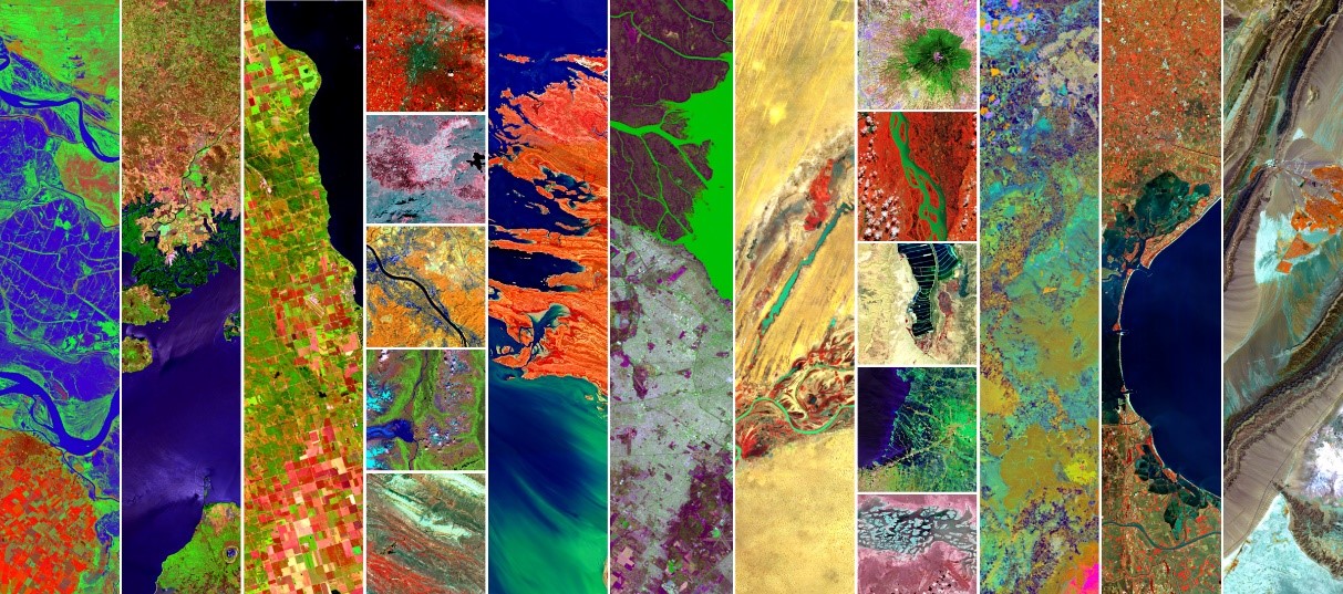
- Environmental Mapping and Analysis Program (EnMAP) - A German hyperspectral satellite mission launched in April 2022 for monitoring terrestrial and aquatic ecosystems. EnMAP images Earth with more than 200 narrow spectral bands in the wavelength ranges of visible light, near-infrared, and short-wave infrared.
- The radar satellite twins TerraSAR-X and Tandem-X, launched in 2007 and 2010, respectively, still deliver high-quality SAR imagery in various modes and contribute to the monitoring of seismic and volcanic hazards, flood mapping etc. Also, data of both satellites have been used to produce Digital Elevation Models, such as the Copernicus global DEMs (GLO-30 and GLO-90).
- Global Geodetic Centre of Excellence (GGCE) - established in Bonn in 2022 to support globally coordinated geodetic infrastructure as the reliable long-term foundation for applications like satellite navigation and space-borne Earth observation. Germany contributes to the GGCE through the Federal Agency for Cartography and Geodesy (BKG).
- The Global Precipitation Climatology Centre (GPCC), hosted by Germany’s meteorological service (DWD) under the auspices of the World Meteorological Organization (WMO), is by far the largest collection worldwide of quality-controlled station-based precipitation measurements.
- The German Federal Institute of Hydrology (BfG) hosts three globally acting hydrological data centres: the Global Runoff Data Centre (GRDC), the International Soil Moisture Network (ISMN), and the UNEP GEMS/Water Data Centre (GWDC).
Besides its national capabilities, Germany is also a strong supporter of the European Union’s Earth Observation programme Copernicus, the “FutureEO” programme of the European Space Agency (ESA), and the programmes of the European Organisation for the Exploitation of Meteorological Satellites (EUMETSAT).
National Policy and Implementation Priorities
Information from Earth observation supports the goals of major multilateral agreements, such as the United Nations Sustainable Development Goals and the Paris Agreement on climate change. Achieving these together is one of Germany’s development policy goals. Fulfilling the associated reporting requirements and verifying the effectiveness of measures, requires the best possible international coordination of Earth observation. As an intergovernmental organization in which more than 100 governments and an equal number of international organizations have joined forces, GEO provides a suitable framework for this. Germany supports GEO particularly in the context of various ‘flagship initiatives’, which are characterized by the fact that they address global problems and monitoring tasks in close alignment with UN initiatives and conventions.
Statements
2026 GEO Symposium / GEO-21 Plenary
26-28 May 26Geneva, Switzerland
Full Statement 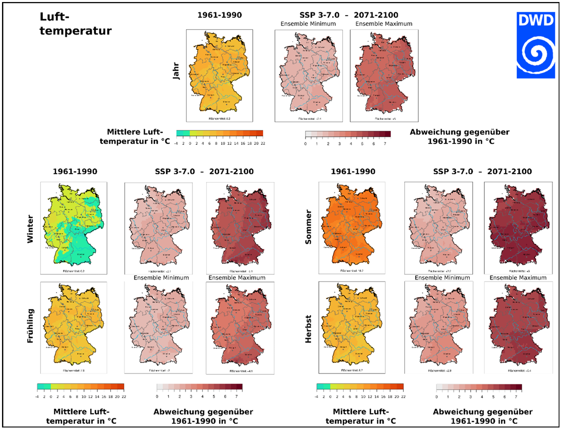

Investing in Earth Intelligence is fundamental to strengthening climate resilience and enabling effective adaptation to climate change impacts. Recent years have shown that extreme weather events – from heatwaves and droughts to heavy precipitation and flooding - are becoming more frequent and impactful, affecting infrastructure and ecosystems as well as human health and lives. The German National Meteorological Service, DWD, provides the scientific foundation to monitor, forecast and project the changing climate risks in support of optimum adaptation to climate change. Our new reference ensembles for instance comprise the latest generation of regional climate projections and undergo a rigorous multi-step evaluation against observations - by disregarding implausible simulations of the past. The resulting ensembles provide a robust and consistent basis for evidence-based adaptation decisions across sectors and regions in Germany. In line with emerging European approaches, such validated data are essential to assess long-term climate variability and trends, anticipate related climate risks, and guide forward-looking adaptation pathways for a resilient future.
Tobias FuchsMember of the DWD Executive Board, Director Climate and Environment Services
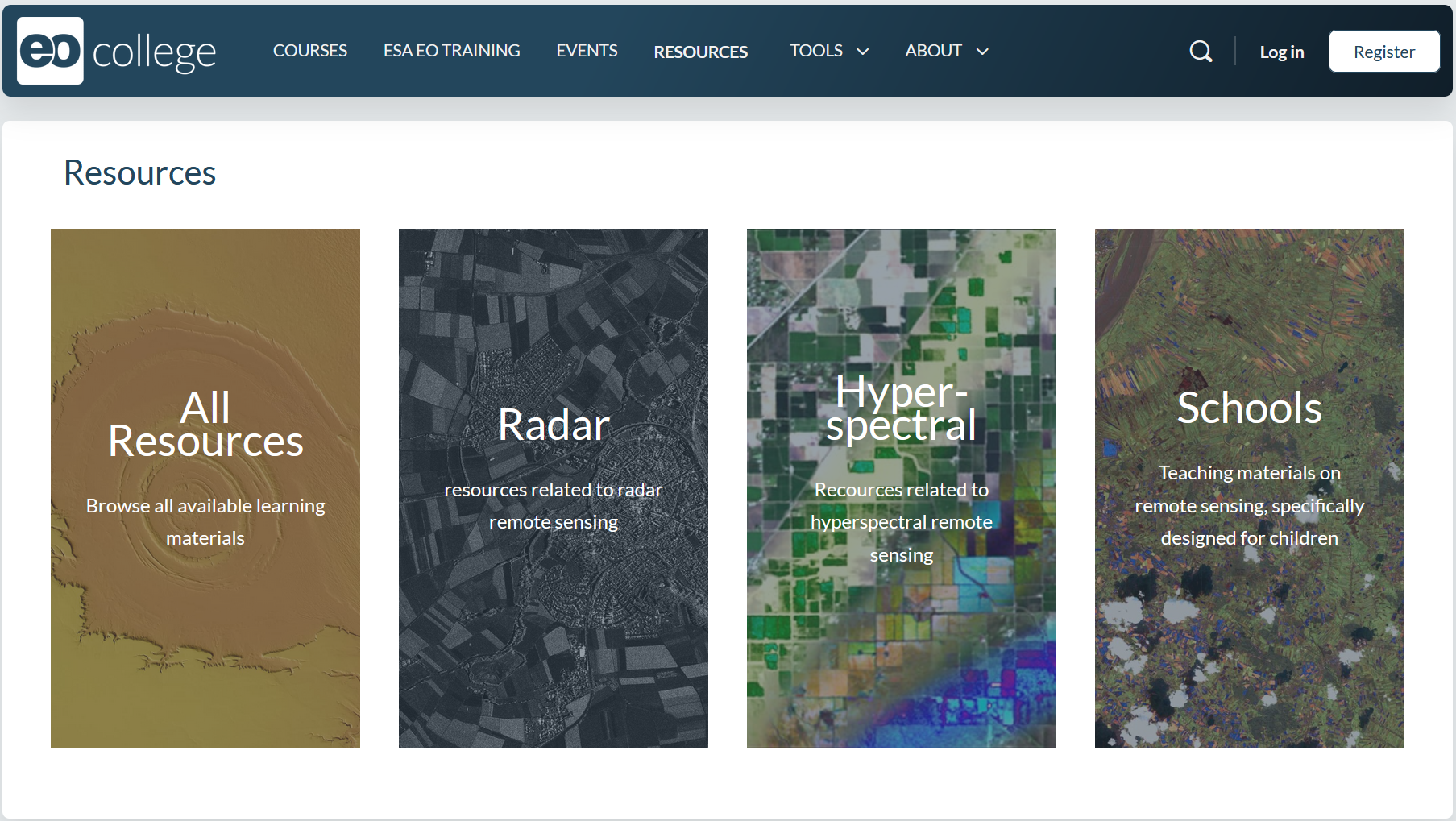
EO College makes Earth observation knowledge accessible to a broad community of users – from schools to adult education – and supports the sustainable development of capabilities in working with remote sensing data. The platform offers open educational resources such as online courses, tutorials, and teaching materials under open licenses (https://eo-college.org/). EO College is operated by EO College e.V. and Ruhr University Bochum and funded by the German Space Agency at DLR.
Godela RossnerHead of Department “Earth Observation”, German Space Agency at DLR
GEO-LDN is about turning data into action. We support countries affected by land degradation not only in meeting SDG 15.3.1 reporting requirements, but in using Earth observation data for better, evidence-based land use decisions. At the same time, ongoing efforts focus on improving access to high-resolution geodata, contributing to global geospatial reporting standards, and enhancing synergies across the Rio Conventions.
Antje HecheltjenLead of the GEO-LDN Secretariat, International Cooperation Agency GIZ
GEO Global Forum 2025
05-09 May 25Rome, Italy
Full Statement 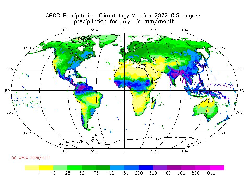
„The Global Precipitation Climatology Centre (GPCC), hosted by Germany’s meteorological service DWD under the auspices of the World Meteorological Organization (WMO), is by far the largest collection worldwide of quality-controlled station-based precipitation measurements. They are used to derive various gridded precipitation products for the Earth's land-surface, as e.g. maps of daily and monthly totals. These products are freely available to the international community and are regularly used in international assessments of the state of climate or water resources.“
Tobias FuchsMember of the DWD Executive Board, Director Climate and Environment Services
The hyperspectral German satellite mission EnMAP (Environmental Mapping and Analysis Program) measures key dynamic processes of Earth’s terrestrial and aquatic ecosystems by extracting geochemical, biochemical and biophysical parameters. Three years after launch, the scientific user community has demonstrated a variety of use cases based on EnMAP’s excellent data quality. User support is ensured through the online learning initiative HyperEDU, the EnMAP-Box toolbox and enhanced data accessibility alongside improved provision of Analysis-Ready Data.”
Godela RossnerHead of Department “Earth Observation”, German Space Agency at DLR
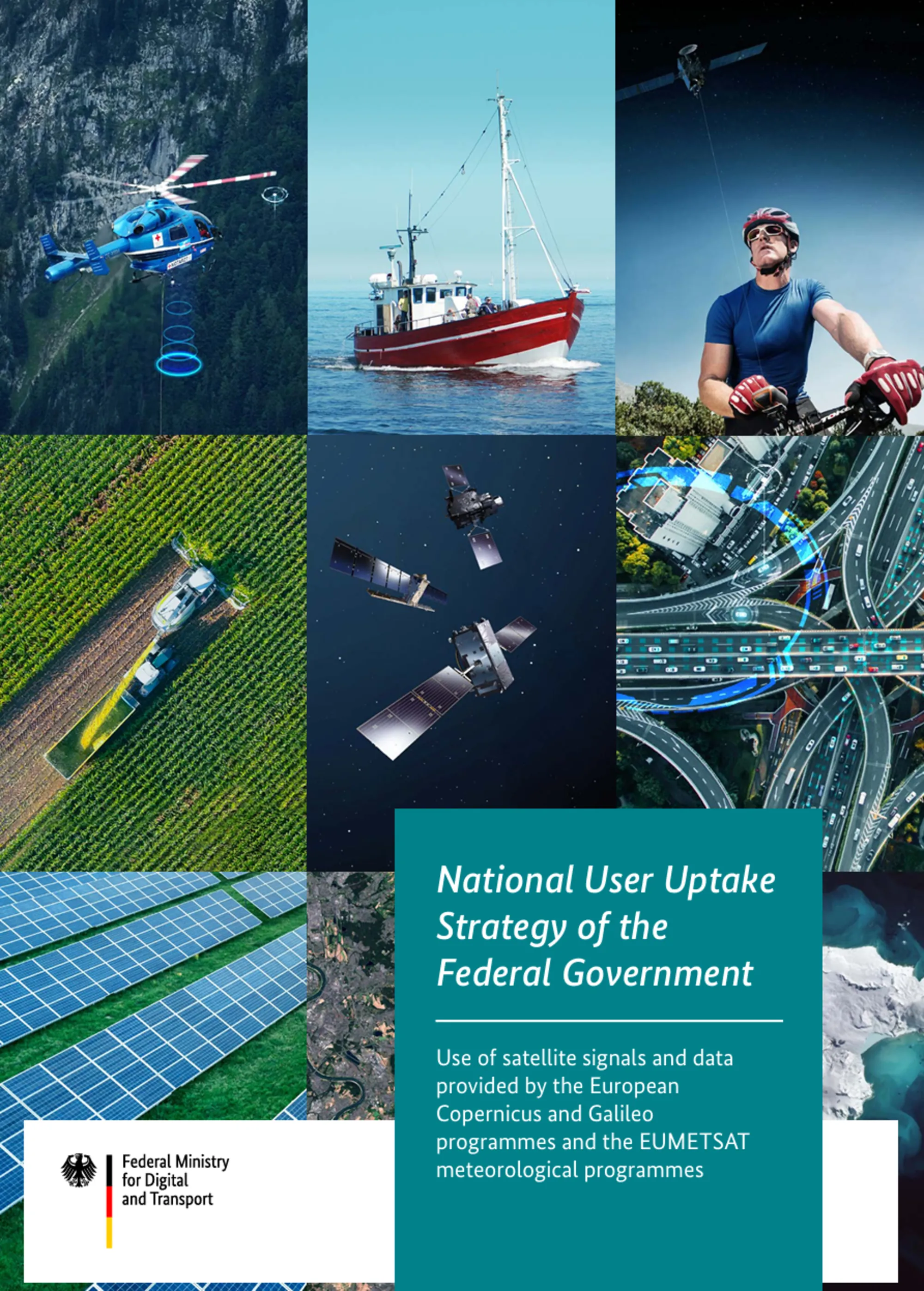
“End of 2024, the Federal German Ministry for Digital and Transport released the User Uptake Strategy of the Federal Government on satellite data for a connected and sustainable society. It is a crucial step towards making targeted and efficient use e.g. of the data and services of Earth observation programmes using satellites that have been continuously developed with great commitment for decades now. The German strategy is the result of a participatory process focusing on user needs. It provides a reliable framework to make optimum use of the opportunities and potential of satellite data and corresponding services for the common good.”
Dirk EngelbartDirector of Division Meteorology, Earth Observation and German Meteorological Service (DWD), German Federal Ministry for Digital and Transport
GEO Week 2023
06-10 Nov 23Cape Town, South Africa
Full Statement 
The Global Geodetic Centre of Excellence (GGCE) started to operate at the UN-Campus in Bonn/Germany in early 2023. The GGCE is going to provide important contributions to a worldwide geodetic infrastructure which is the reliable long-term foundation for applications like satellite navigation, space-borne Earth observation, and the monitoring of the UN Sustainable Development Goals. The Federal Agency for Cartography and Geodesy (BKG) is an international geodetic reference as operator of geodetic observatories on three continents and will support the work of the GGCE with its expertise. Germany – through BKG – contributes to the success of the GGCE by providing the necessary financial means to establish and start the GGCE.
Paul Becker President, Federal Agency for Cartography and Geodesy (BKG)
Global urban development and health risks from climate change and air pollution can be assessed using the services ‘World Settlement Footprint’ and ‘Atmospheric Composition Monitoring’ as provided by DLR’s Earth Observation Center (https://geoservice.dlr.de/web/). To develop healthy and climate-resilient cities and assess the urban environment under current and future climate conditions and mobility scenarios these satellite products need to be combined with Urban Climate Models, like PALM-4U. As a contribution to EuroGEO, DLR developed services on “Urban Health Risks from Air Pollution” (https://www.alpendac.eu/eshape) and “Urban Climate Under Change.
Given the demand for integrated assessments of multiple urban health risks, the development of user-driven services is essential. By following a rigorous co-design process, we look forward to contributing to GEO and strive for a continued uptake in science, planning and economy.
Thilo Erbertseder Research Scientist and Project Manager, Earth Observation Center at DLR
The Federal Institute for Geosciences and Natural Resources (BGR) carries out several development cooperation projects with African, Latin American and Asian partner countries. Many different, mainly freely available satellite data (e.g. Copernicus, Landsat), digital elevation models and geological survey data are used in these projects.
The cooperation project with the Geological Survey of Bangladesh (GSB) “Geo-Information for Urban Planning and Adaptation to Climate Change” supporting the planning agencies in pilot cities data was successfully completed concerning the EO data aspect. The regional capacity enhancement for geothermal exploration in four countries of SICA (Central America Integration System) is currently being continued in the form of intensified training and application workshops.
Dr. Michaela Frei Head of Unit “Remote Sensing”; Department “Geoscientific Information, Geoscientific Cooperation”; Federal Institute for Geosciences and Natural Resources.
GEO Week 2022
31 Oct 22 - 04 Nov 22Accra, Ghana
Full Statement 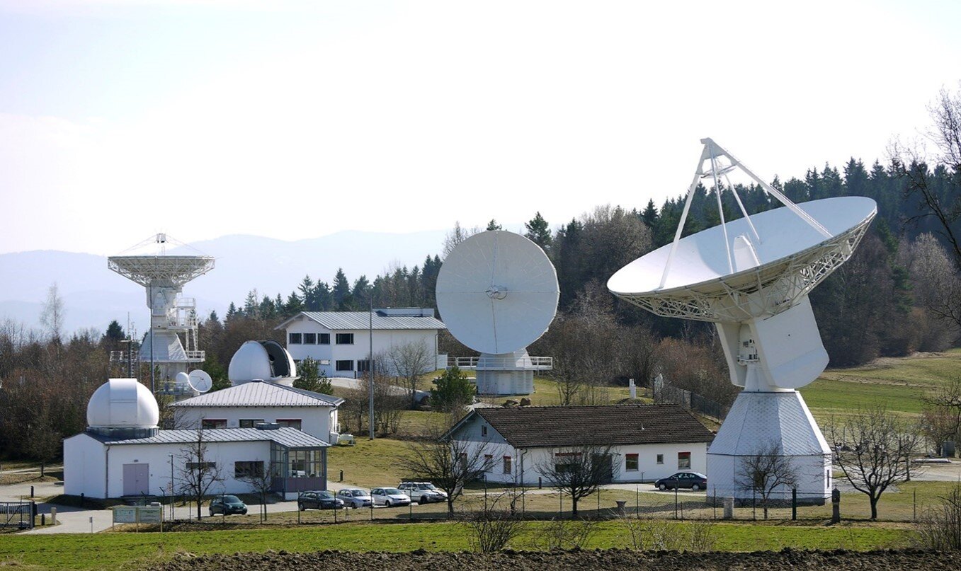
The Global Geodetic Centre of Excellence (GGCE) will be formally established at the UN-Campus in Bonn/Germany by the end of 2022 and start to operate in early 2023. Its establishment has been decided by UN-GGIM back in 2020. With the GGCE, Germany supports the establishment of a sustainable globally coordinated geodetic infrastructure as a basis for Earth Observations and Navigation applications. It allows, for instance, more efficient and accurate monitoring of sea level or earth crust changes. The GGCE will in particular support developing countries and foster open exchange of geodetic data.
The Federal Agency for Cartography and Geodesy (BKG) is an international geodetic reference as operator of geodetic observatories on three continents and will support the work of the GGCE with its expertise. Germany will – through its Federal Agency for Cartography and Geodesy (BKG) –contribute to the success of the GGCE by providing the necessary financial means to establish and start the GGCE.
Paul Becker President, Federal Agency for Cartography and Geodesy (BKG)
The Federal Institute for Geosciences and Natural Resources (BGR) carries out several development cooperation projects with African, Latin American and Asian partner countries. Many different, mainly freely available satellite data, digital elevation models and geological survey data are used in these projects, e.g.:
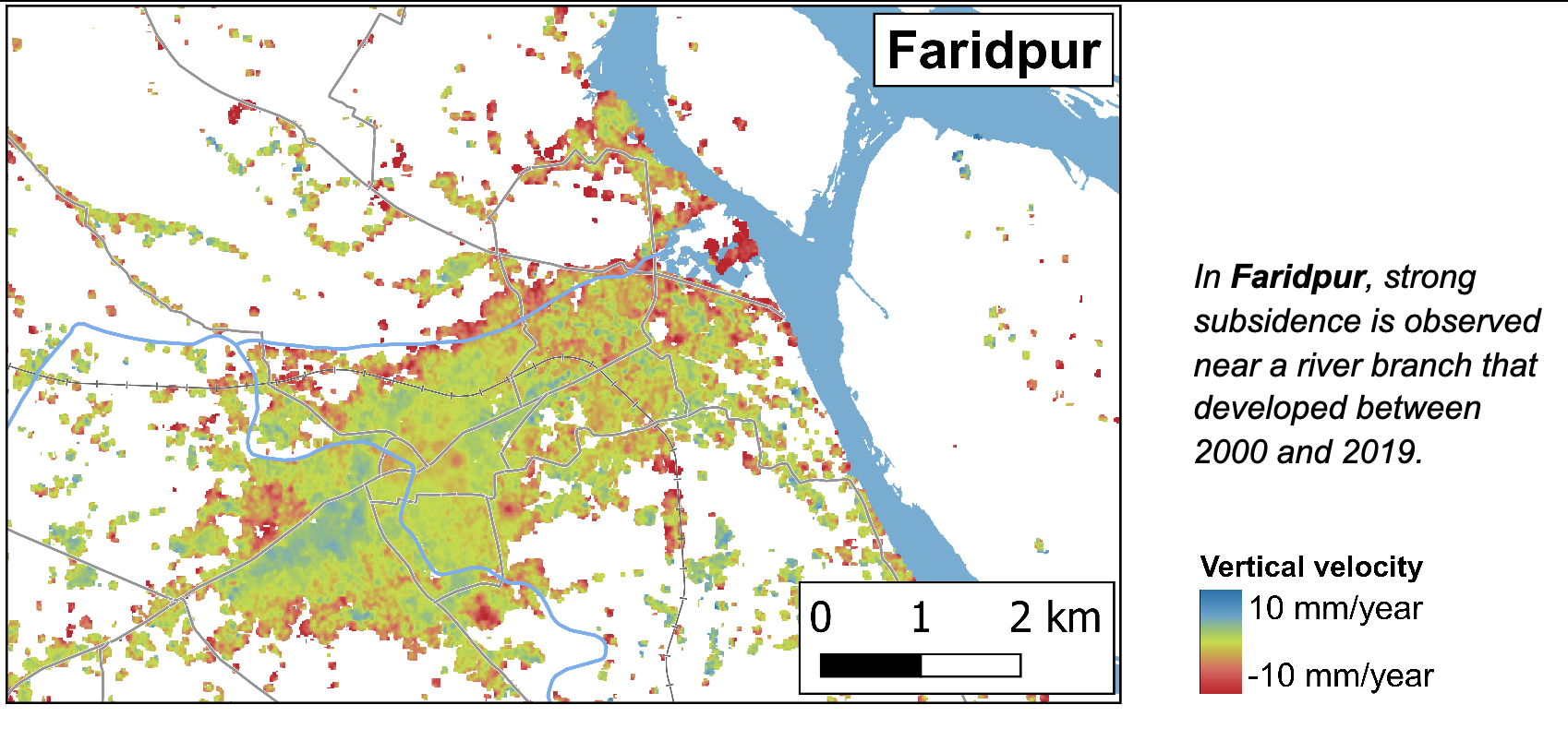
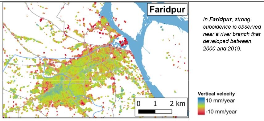
In cooperation with the Geological Survey of Bangladesh (GSB), the project “Geo-Information for Urban Planning and Adaptation to Climate Change” supports the planning agencies in the pilot cities of Kushtia, Faridpur, Satkhira, Barisal, Sirajganj and Khulna with remote sensing observations based on Copernicus Sentinel and Landsat data. Linking e.g. land-use with inundation data and river-course monitoring with InSAR-derived multi-temporal ground motion for the pilot city of Faridpur enables a comprehensive view on geo-hazards, building ground suitability and the underlying processes within a planning area.
The project “Geothermal Energy in East Africa” includes cooperation with the Djiboutian project partner Office Djiboutien de Développement de l’Énergie Géothermique (ODDEG).
The regional capacity for geothermal exploration in four countries of SICA ("Central America Integration System"), which acts as a political partner, is realized through activities in Costa Rica, Nicaragua, El Salvador, and Guatemala. Several remote sensing methods are applied to provide support for current geothermal exploration studies.
Dr. Michaela Frei Head of Unit “Remote Sensing”; Department “Geoscientific Information, Geoscientific Cooperation”; Federal Institute for Geosciences and Natural Resources.
“The Environmental Mapping and Analysis Program (EnMAP) is a German hyperspectral satellite mission that aims at monitoring and characterizing Earth’s environment. EnMAP measures key dynamic processes of Earth’s terrestrial and aquatic ecosystems by extracting geochemical, biochemical and biophysical parameters. The mission was successfully launched in April 1st 2022. Routine operations has started on November 2, 2022. Data is now provided with a free and open data policy to the global scientific user community.
To visualize and process imaging spectroscopy data the EnMAP Toolbox was developed and is provided freely to the community. And with the online learning initiative HYPERedu hosted on the EO-College Platform, we support the GEO community in practicing the use of imaging spectroscopy for local environmental challenges and global cooperation. Further information on the mission, news and announcements of opportunities are available on https://www.enmap.org/.”
Godela Rossner Head of Department “Earth Observation”, German Space Agency at DLR