Sophie Hebden
GEO PrincipalGEO Principals
Fumiko Kasuga
GEO Principal AlternateFocal Points
Statements
GEO Week 2023
06-10 Nov 23Cape Town, South Africa
Full Statement


GEO BON with Future Earth Canada, and Sustainability in the Digital Age are conducting a survey of expert perceptions on the use of AI for biodiversity and ecosystem management to spark dialogue, identify knowledge gaps, and support the growth of a multi-sectoral community toward meeting the goals of the Global Biodiversity Framework. This will contribute to a white paper assessing the opportunities and challenges of AI for biodiversity measurement and reporting, and inform recommendations for effective corporate reporting.
Nilufar Sabet-Kassouf Future Earth Canada

bioDISCOVERY is a strong supporter and implementer of GEO BON. The network collaborated with the GEO BON initiative in 2022 on a set of policy briefings and publications for CBD COP15. The two networks also held a joint workshop at the World Biodiversity Forum in June 2022, to discuss how to improve the flow of information from biodiversity monitoring and research to guide action. The workshop outcomes are published in Gonzalez et al, 2023, Nature Ecology & Evolution, ‘A global biodiversity observing system to unite monitoring and guide action’. A follow up workshop is planned for WBF 2024.
Cornelia Krug Executive Director - bioDISCOVERY

The Global Mountain Biodiversity Assessment (GMBA) engages with GEO through its contribution to GEO Mountains. It co-led the identification of a set of Essential Biodiversity Variables for assessing change in mountains together with the Mountain Research Initiative (MRI). This effort was initiated through a common workshop held at EGU in 2023. GMBA further supports the vision of GEO BON by promoting biodiversity observation efforts that contribute to the effective management of mountain biodiversity and mountain ecosystems worldwide.
Dr. Davnah Urbach GMBA office, University of Bern, Switzerland

oneHEALTH
Research in Future Earth’s oneHealth group centers on understanding how environmental, animal and human health are interconnected. To integrate the environmental aspect in our research we are using Earth observations of forest cover and land use mapping (ESA with 10 meter resolution, for example, or Landsat with 30 meter resolution) to understand how deforestation, land use change, or forest configuration (fragmentation, the amount of forest edges, etc), are affecting disease risk and human health. The figure below shows a map with forest core areas and forest edges created from the ESA mapping. This mapping is being used to create a Nipah Virus risk map for Bangladesh.
Paula R. Prist Senior Scientist - EcoHealth Alliance

Water Futures / NEXUS
Research in the water-energy-food nexus centers on the interconnections among these three vital components, requiring the collection of data in a synergistic manner for comprehensive nexus analysis. However, conventional research approaches have historically separated data collection into distinct ''spheres'' of water, energy, or food, resulting in spatial and temporal mismatches that limit their utility for nexus analysis. Earth observation systems offer a promising avenue for gathering data at spatial and temporal scales conducive to nexus studies. The NEXUS KAN is establishing its international project office in Hainan, China, and is keen to collaborate with GEO's initiatives such as GEOGlows and AquaWatch.
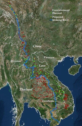
Hydroelectric dams in the Mekong River Basin. Regular satellite observations of hydropower dams can capture their water storage for electricity generation and simultaneous distribution for crop irrigation and food production. By enabling long-term monitoring of water quantity and quality, these observations facilitate in-depth analyses of the dynamic linkages between water, energy, and food systems and the implications for local communities.
Jiaguo Qi Michigan State University, USA
