EuropeMember since 16 Feb 2005
European Union


GEO Engagement and Contributions
Key contributions and leadership
The European Union, represented by the European Commission, is a founding member of GEO and has actively engaged in GEO governance since 2005. It has since been one of the Co-Chairs of the Executive Committee and plays an active role in the Plenary.
The Commission is a major donor to the GEO Trust Fund through voluntary annual contributions. The European Commission has also provided substantial funding for GEOGLAM, GEO Blue Planet, and to the Global Heat Resilience Service and the Ecosystems Atlas through the iClimateAction project.
It has significantly contributed to the vision and mission of GEO through various EU programmes, including Horizon Europe, Copernicus, and the Digital Europe Programme. With its free and open data policy, the Copernicus programme provides EO data from a wide range of satellite systems, which are today used globally in many GEO activities.
The European Commission Joint Research Centre (JRC) is actively engaged in a number of GEO activities, providing data, tools and expertise to GEO activities, including the GEO Human Planet Initiative and the GEOGLAM Flagship.
The lead entity that engages with GEO from the European Commission is the Directorate-General for Research and Innovation (DG RTD), with the Joint Research Centre (JRC) serving as a key technical focal point, and DG for Defence Industry and Space (DEFIS) which runs the Copernicus programme.
Most recently, the European Commission sponsored the GEO Global Forum 2025 hosted by Italy in May 2025, as well as the first GEO Youth Ideathon in South Africa 2023, followed by a second edition in Rome 2025.
Participation in the GEO Work Programme
The European Union as represented by the European Commission, is deeply committed to advancing solutions to climate, environment, disaster risk reduction worldwide through leading contributions to several key GEO Work Programme activities. In 2025, the Commission launched a 15 M€ call for “Delivering Earth Intelligence to accelerate the green and digital transition” which asks for operational contributions to the GEO work programme activities, based on GEO’s Post-2025 Strategy “Earth Intelligence for All”.
The Human Planet Initiative (HPI) coordinated by the Commission’s JRC, plays a central role in developing global-scale, high-resolution datasets on human settlement patterns and exposure. These data support risk assessments and guide policies for more resilient urban and regional planning, including for climate and hazard adaptation across Europe and globally. Additionally, the EU is the founder and the host of the core team for the Global Wildfire Information System (GWIS), which integrates satellite-based wildfire monitoring with in-situ observations of wildfires to improve early warning and preparedness. The Commission's iClimateAction funds the Global Heat Resilience Service (GHRS), which is developing an operational service that will provide every urban area in the world with actionable intelligence on the health and economic risks posed by extreme heat.
The European Union and European agencies also contribute actively to other disaster risk reduction initiatives of GEO. Through the European Space Agency, the European Centre for Medium-Range Weather Forecasting, and the Joint Research Centre, Europe supports GEOGLAM for enhancing global agricultural monitoring for food security, GEOGloWS for flood early warning, and GEO Mountains for strengthening resilience in mountain regions. With another Horizon Europe funded project, TEMBO Africa, the Commission supports the GEO pilot “In Situ Observations and Modelling for Weather, Water, Environment, and Climate Services in Africa”, advancing biodiversity and ecosystem-based approaches to reduce vulnerability to climate-related hazards. Together, these integrated efforts demonstrate the EU’s commitment to leveraging Earth observations for multi-hazard risk reduction, enhancing societal resilience, and promoting science-based policy for a safer and more sustainable future.
The European Union, through the JRC and/or Horizon Europe funded projects, is involved in the following GEO Work Programme activities:
- HUMAN PLANET
- Global Heat Resilience Service
- TEMBO
- GOS4M
- GEO-MIN
- GWIS
- SPACE-SECURITY
- GEOGLAM
Role of Private Sector in GEO
The European Commission actively promotes private sector engagement in GEO through:
- The launch of the first EO Pre-commercial Procurement (PCP) action for the private sector to develop user defined applications (PCP WISE)
- The engagement of the Private sector in EuroGEO via the European Association of Remote Sensing Companies (EARSC).
- The conclusion of industrial partnerships to boost competitiveness and innovation within the European space sector (CASSINI initiative).
- The mobilisation of the Digital Europe Programme to leverage partnerships with the private sector to develop highly accurate digital models of the Earth, enabling better monitoring and prediction (Destination Earth).
- The creation of innovative products and services that address various societal and economic needs leveraging the free and open data provided by the Copernicus downstream services
Through the Copernicus Data Space Ecosystem (CDSE), the Commission offers a wide range of infrastructure, services, and tools designed to unlock the full potential of Earth observation data, open to 3rd Party Services to deploy and operate their applications and services.
Participation in Regional Caucus - EuroGEO
In 2017, the European Commission launched the EuroGEO initiative as a regional branch of GEO, which combines European Earth observation resources, coordinates EO-related research activities for GEO, and fosters collaborations across Europe and globally.
Since the EuroGEO initiative was launched, the EU contributions to the achievements of GEO have been instrumental, across all priority areas of GEO. In particular, through promoting EuroGEO’s mandate through workshops and projects (e-shape, EuroGEOsec), and by providing EO infrastructure, data management systems and applications developed through Horizon-funded projects, which are used throughout the GEO work programme.
The European Commission also serves as the co-chair of the EuroGEO alongside European GEO Members and coordinates the European position in GEO’s governance structures.
Earth Observation Capabilities
The European Commission operates comprehensive Earth observation capabilities, including:
- Copernicus Programme: The EU's flagship Earth observation programme providing operational environmental monitoring services through six thematic services (Atmosphere, Marine, Land, Climate Change, Security, Emergency Management)
- EU Space Programme: consisting of several flagship components such as Copernicus, EGNOS (European Geostationary Navigation Overlay Service) or Galileo, Europe’s Global Navigation Satellite System.
- Horizon EuropeFramework Programme - Major research funding for Earth observation innovation and technology development with budget allocation of EUR 1.4 billion for space research (2021-2027).
- Digital Europe Programme - Supporting development of European Earth observation data spaces and AI applications for environmental monitoring.
Statements
2026 GEO Symposium / GEO-21 Plenary
26-28 May 26Geneva, Switzerland
Full Statement 

The European Union aims to lead in the space economy by 2050. Central to this vision is Copernicus, which continues to provide free, full, and open access to high-quality data, supporting innovation, sustainable development, competitiveness and global cooperation
Giancarlo Granero European Commission, DG Defence Industry and Space
Copernicus has revolutionized Earth observation, addressing key societal priorities such as environmental monitoring, climate change, and disaster management. Copernicus free, full, and open data foster a culture of innovation and enables policymakers and the public to make informed decisions. As such, Copernicus represents a major contribution to GEO and broader Sustainable Development Goals.
Mauro Facchini European Commission, DG Defence Industry and Space
The European Environment Agency (EEA) recognises the significant value of the GEO community and remains committed to strengthening the sharing and use of Earth observation and in situ data in support of environmental and climate policies. Earth observation is an increasingly key enabler of the core work of the agency and the European Environment Information and Observation Network (Eionet), in contributing to Europe's transition towards sustainability.
EEA's contribution to GEO includes the launch in 2024 of the project “Enhancing the access to in situ Earth observation data in support of climate change adaptation policies and activities”, funded by the European Commission (DG RTD). Now in its second year, the project has already made a strong contribution to GEO, notably through the drafting of the GEO In Situ Data Strategy, endorsed in November 2025, and through ongoing support to its implementation plan.
The project has also contributed to the development of success stories and dialogues showcasing best practices and demonstrating the added value of open data principles. In parallel, the EEA continues to develop the Geospatial In-Situ Requirements Database (Greqs) to document and manage user needs across the GEO Work Programme. Through close engagement with the community, this work supports requirement identification and facilitates matchmaking with data providers. Together, these efforts aim to improve the availability and accessibility of in situ data, thereby advancing the GEO vision of Earth Intelligence for a Resilient Future.
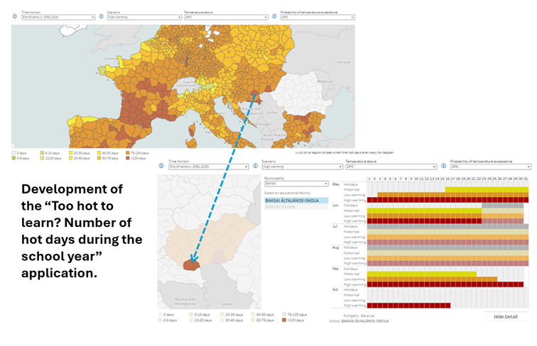
In addition, the project developed practical showcases illustrating how openly available in situ data can inform decision making and promote resilience to climate change. One such example is a tool combining school locations, holiday calendars and localised climate projections to assess potential impacts of rising temperatures and help school develop resilience strategies.
EEA is also proud of its role as Entrusted Entity in charge of the Land component (CLMS) of the Copernicus programme and coordinating the Copernicus In Situ Component and has recently finalised the Copernicus In-Situ Component 2028–2034 strategy. Among the key pilars of this strategy is the cooperation with data providers at national, regional and global level, as well as aspects related to resilience and strategic autonomy, which rely on the diversification of partnerships and in-situ sources for Copernicus. In this context, the EEA sees GEO as a key strategic partner, providing a unique global platform to connect in situ communities, align efforts, and promote open and interoperable Earth observation data worldwide.
Karl Hamilton European Environment Agency (EEA)
Earth Intelligence places the user and their institutional context at the centre of the value chain, from data to societal impact. It requires the conditions for heterogeneous actors to function as a coherent system, capable of continuously learning and adapting to the demands of our time. Through EuroGEOSec, EuroGEO has worked to build the institutional and organizational foundations that make this possible: shared practices, structured co-design, and an enabling ecosystem contributing to the Twin Transition in Europe and supporting the Earth Intelligence transformation within GEO. This is the enabling role a EuroGEO Secretariat can take.
N. Fichaux, T. Ranchin, L. Ménard, M. Reboul MINES Paris PSL
At the JRC, we see Earth Observation and AI not as an end in itself, but as the foundation for Earth intelligence — the capacity to turn satellite data together with other data streams into actionable knowledge that directly serves policy. Our Earth Observation community is increasingly working across disciplinary boundaries, combining Copernicus data with in-situ networks, modelling, and AI to deliver integrated assessments that policymakers can act on. This is also the spirit in which the JRC contributes to GEO flagships such as GEOGLAM — where we hosted a workshop last year to prioritise Essential Agricultural Variables, translating the community's collective expertise into a shared framework for monitoring global agriculture & food security. The GEO partnership remains essential to this mission: no single institution or programme can build Earth intelligence alone.
Alessandra Zampieri European Commission, Joint Research Centre
To tackle today’s challenges, we need access to reliable and relevant information. By supporting the Group on Earth Observation, we turn data into practical tools that help countries anticipate risks, respond to disasters and plan ahead and make them more accessible to those who need it the most. Through Global Gateway, we reinforce these efforts, investing in trusted partnerships that strengthen local capacity and drive innovation. For example, with initiatives like the Africa-EU Space Partnership and our Copernicus hubs in Panama, Chile and the Philippines.
Jozef Síkela European Commission
"At iClimateAction, our work with the GEO Community is to ensure that Essential Climate Variables are not only monitored, but also made accessible and usable across institutions. As the volume of Earth observation data continues to grow, the real challenge is no longer data availability, but its interoperability, coherence, and effective use across systems.
By bringing together GEO, the World Meteorological Organization and the Global Climate Observing System, we are working to harmonise the ECV data chain and address fragmentation in governance, infrastructure and standards - so that data can move more seamlessly from observation to action."
Paolo LajChief, Atmospheric Environment Research, World Meteorological Organisaton (WMO), iClimateAction Project Coordinator
GEO Global Forum 2025
05-09 May 25Rome, Italy
Full Statement 


European Commission, Directorate General for Defence Industry and Space.
Unit DEFIS.D.3.
Copernicus has revolutionized Earth observation, addressing key societal priorities such as environmental monitoring, climate change, and disaster management. Copernicus free, full, and open data foster a culture of innovation and enables policymakers and the public to make informed decisions. As such, Copernicus represents a major contribution to GEO and broader Sustainable Development Goals.
Mauro FacchiniHead of Unit, Earth Observation, Directorate General for Defence Industry and Space, European Commission
European Commission, Directorate General for Defence Industry and Space.
Unit DEFIS.C.3.
“Copernicus free and open powers a wide range of downstream services and plays a key role in advancing the global Earth observation ecosystem and supporting GEO’s objectives. It has spurred innovation and economic growth, fostering a vibrant European space economy and a dynamic downstream sector, translating space data into real-world impact”.
Jolanda Van EijndthovenHead of Unit, Space Economy, Directorate General for Defence Industry and Space, European Commission
European Commission’s Directorate General for International Partnerships.
"The Africa-EU Space Partnership Programme, a Global Gateway flagship initiative, represents a pivotal step in strengthening the ties between Europe and Africa, leveraging the power of space technologies to drive sustainable development, enhance climate resilience, and foster innovation. Through this collaboration, we are not only advancing Africa's green and digital transition but also empowering its private sector and institutions to shape a more resilient society."
Carla MontesiDirector for Green Deal and Digital Agenda at the European Commission’s Directorate General for International Partnerships.
European Commission, Joint Research Centre. “As we enter the third decade of the work of the Group on Earth Observations, our common global focus is on evolving existing Earth Observation products and services to Earth Intelligence, recognizing the critical role that this transformation will play in addressing the world's most pressing challenges, such as climate change and sustainable development. The European Commission’s Joint Research Centre, in collaboration with international partners and stakeholders, fully embraces this. We increasingly see in our work supporting the policy needs of European Union for Earth Observation and the multilateral UN system, that Earth Observation can only reach its full potential if it is combined and integrated with other sources of data, providing actionable intelligence that can help drive policy coherence. We are convinced that the next decade of GEO will be a transformative period for how Earth Observations impact policy, decision-making, and the lives of citizens worldwide, fostering a more sustainable, equitable, and resilient future for all.
Alessandra ZAMPIERIDirector of the Directorate for Sustainable Resources, European Commission, Joint Research Centre (JRC), Italy
European Environment Agency (EEA). “The European Environment Agency (EEA) recognises the importance and significant value of the GEO community and is committed to continuing its efforts to enhance the sharing and use of Earth observation data in support of environmental and climate policies. Funded by the European Commission (DG RTD), the EEA launched in 2024 a second three-year project, “Enhancing the access to in situ Earth observation data in support of climate change adaptation policies and activities”. Through this initiative, the EEA is actively engaged in GEO and EuroGEO data sharing activities.
Within this context, the EEA contributes to the GEO Data and Knowledge Working Group, promoting open data sharing and sound data management practices across the Earth observation community. We have supported the development of GEO success stories that demonstrate the value of implementing open data principles and we are actively contributing to the formulation of the post-2025 GEO In-Situ Data Strategy.
In addition, the EEA is developing and maintaining the Geospatial In-situ Requirements Database (G-reqs), a tool to document and manage in situ data user needs across the GEO Work Programme. This work builds on our role as coordinator of the Copernicus In-Situ Component. We will soon begin engaging with in-situ data providers to help align identified needs with available data sources. These efforts aim to enhance the availability and accessibility of in-situ data, furthering the GEO vision of Earth Intelligence.
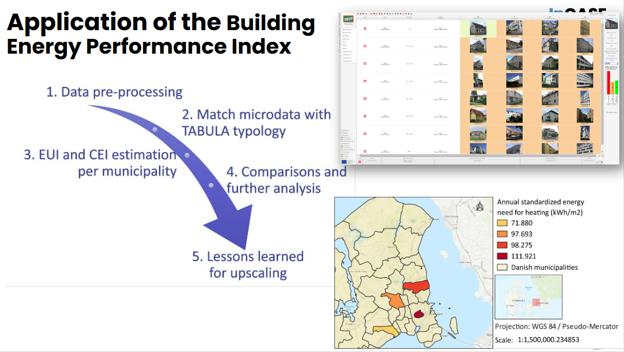
The project also includes the development of practical showcases illustrating how openly available in-situ datasets can support climate adaptation policies. For example, we have developed a methodology that combines building level microdata, provided by local authorities with national residential building typologies (extracted from the TABULA webtool) to calculate a Building Energy Performance Index at municipal level, with an initial application in Denmark.
As one of the EU agencies entrusted with the implementation of the Copernicus component of the EU Space Programme —specifically the pan-European products of the Copernicus Land Monitoring Service (CLMS) and coordination of the Copernicus In-Situ Component— EEA sees the role of the GEO community as key. GEO initiatives can leverage CLMS products, know-how and expertise to achieve their objectives. At the same time, GEO offers a unique platform to connect with key in-situ partners and to promote open data and open observation principles on a global scale”.
Karl HamiltonHead of Digital Department and GEO Principal, EEA, Denmark
Horizon Europe Project EuroGEO Secretariat (EuroGEOSec). The EuroGEOSec project develops a fully operational and sustainable EuroGEO Secretariat contributing to the Regional initiative EuroGEO.
EuroGEO promotes, showcases and stimulates Combination, Coordination and Cooperation to serve European and international policies and users through Earth Intelligence leveraging European excellence by:
● Actively stimulating and monitoring the European contribution to GEO and increasing GEO benefits for Europe,
● Acting as a Coordination forum for European and national initiatives relevant to both the GEO work programme and European priorities.
● Addressing the significant gap between policy needs, end-user requirements, and technology providers
● Ensuring a broad participation of both demand and solution providers, leveraging the entire Copernicus value chain and user community, the private sector, and platforms/twins/infrastructures within its Action Groups.
● Supporting Action Groups mobilised as agents of change
Thierry RanchinDirector of the Centre Observation, Impacts, Energie from MINES Paris – PSL, France and Scientific coordinator of the EuroGEOSec Project
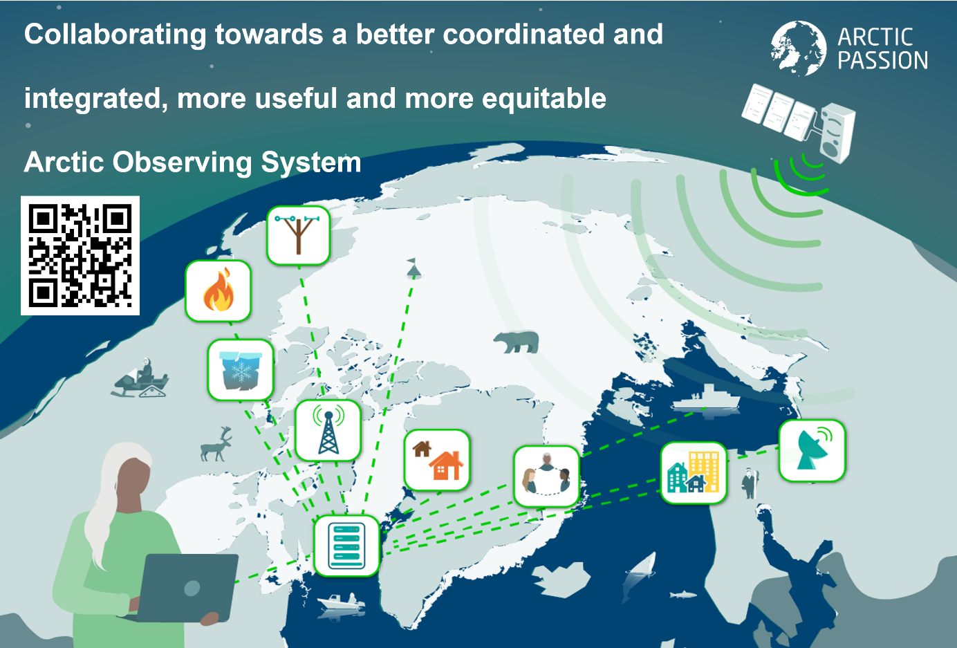
Horizon Europe Project Arctic PASSION. Comprehensive Arctic observing is needed more than ever with the rapid pace of local climate change. Arctic PASSION has taken great effort to involve Indigenous communities and local people with researchers in observation making and reaping benefits from the related EO services.
Alfred Wegener Institute, Germany, Coordinator Arctic PASSION
Horizon Europe Project EO4EU. “EO4EU Unleashes the potential of Earth observation data through AI and extended reality—empowering everyone to explore, analyse, and act.”
EO4EU has an easy-to-use interface including personalized dashboards, a smart search engine and data visualization, analysis and interpretation. Users can also write their own code and execute it serverless with minimum effort. Finally, EO4EU provides an immersive experience with its augmented and extended reality interface.
The EO4EU project has made an invaluable contribution to FAIRifying EO data with its one-stop shop that facilitates finding, accessing and reusing EO data and analyses (https://bit.ly/4h6vvDk). It significantly contributes to advancing environmental knowledge at local and EU levels.
Stathes Hadjiefthymiades National and Kapodistrian University of Athens, Greece, project coordinator
Horizon Europe Project Open-Earth-Monitor (OEMC). “In a world of AI technology exceeding our best experts and replacing jobs at a rapid pace, it is crucial to have transparent processes, models trained using FAIR (open findable accessible interoperable and reusable data). This can be best achieved by using and enabling open source software and open data, i.e. by supporting and enabling open development communities, especially in the field of Earth Observation and spatial data science.
OEMC embraces the use and extension of open-source software, open reproducible procedures and data sharing. Building on several existing platforms, such as Copernicus Data Space Ecosystem and data from the European Environmental Agency, users can improve existing data and services and develop their own.
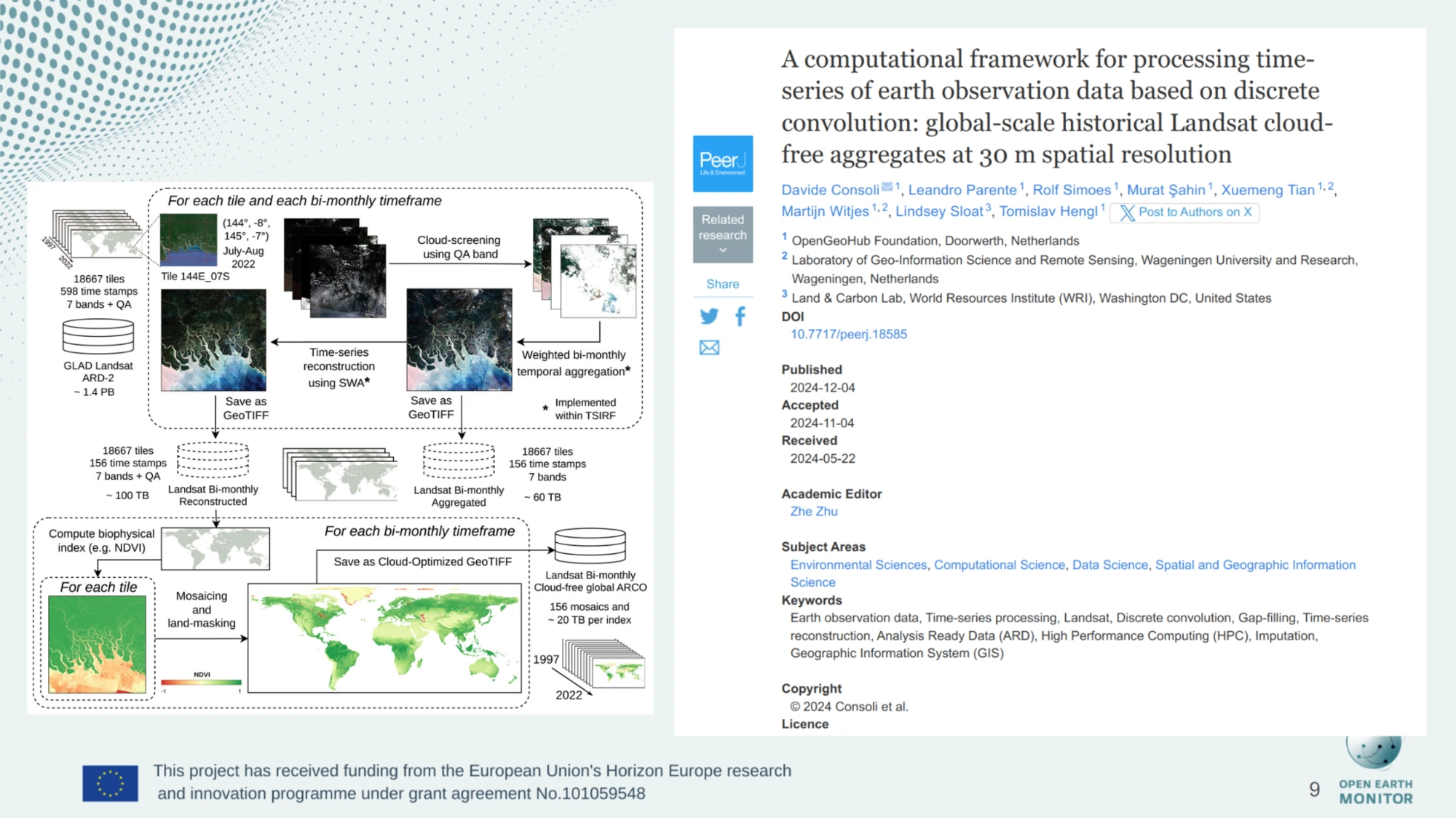
OEMC also produced several new data sets, such as land degradation hot spots supporting the United Nations’ Convention to Combat Desertification, or datasets used to map drivers of deforestation across Africa. Also developed a computational framework employed to produce cloud-free, data sets with applications including land cover analysis and crop-type mapping.
OEMC currently has more than 20 monitors with pilot use cases such as the ‘World drought monitor’, ‘EU biodiversity monitor’ and ‘Tropical deforestation monitor’ (Ethiopia) in which users are at the centre of monitors’ design, and applications are often developed in close collaboration. Use cases are currently uploaded to the GEO’s Knowledge Hub.”
Tomislav HenglDirector OpenGeoHub foundation, The Netherlands
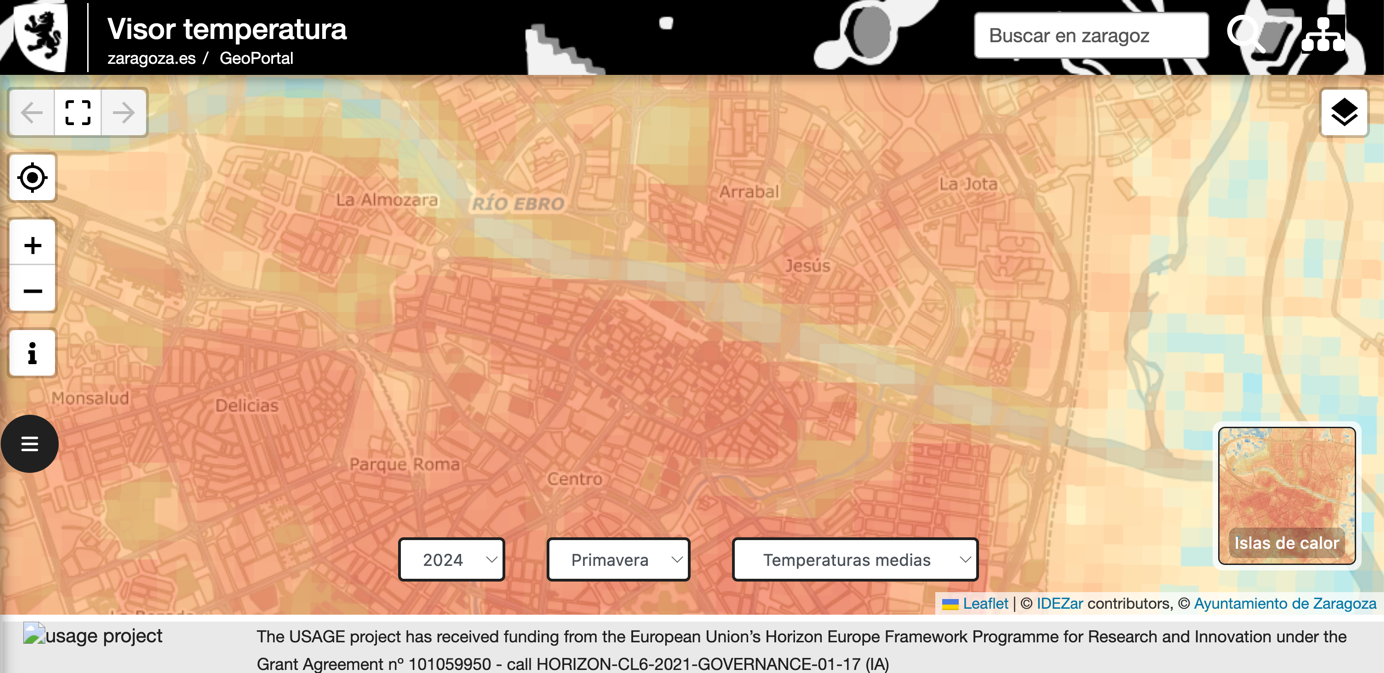
Horizon Europe Project Urban Data Space for Green Deal (USAGE). “In the project USAGE we are paving the way to create urban data spaces that focus on problems identified in the Green Deal. Notably, we use open EO data to characterize urban heat islands, and combine such data with other data sources to determine how they affect population in urban areas”
Oscar CorchoFull professor, Universidad Politécnica de Madrid, Spain
GEO Week 2023
06-10 Nov 23Cape Town, South Africa
Full Statement 
The Group on Earth Observations (GEO) is working closely with Copernicus, the Earth observation component of the European Union (EU)’s Space Programme, as well as Horizon Europe, EU’s Research and Innovation Programme, to bring together global Earth observation and other data in support of Sustainable Development Goals, Climate Action, Disaster Risk Reduction and broader policy and decision making in a wide range of sectors. From the start, Copernicus was conceived, designed, and implemented as the EU contribution to GEO with similar free and open data policy principles. As an example, ‘maps without gaps’ developed by the Copernicus Climate Change Service (C3S) use a wealth of observations from those many data streams and allow tracking climate variability and change over time in a consistent way so as to support EU’s climate mitigation and adaptation strategies.
Mauro Facchini Head of Earth Observation at the Directorate General for Defense Industry and Space, European Commission
In a data driven economy, earth observation data and services are a game changer and essential input in building sustainable Early Warning Systems for effective climate change adaptation and disaster risk reduction. The European Commission committed to support the strengthening of Africa Multi-Hazard Early Warning and Early Action System (AMEWHAS), ultimately contributing also to the GEO work programme priorities on Disaster Risk Reduction.
Carla Montesi Director for Green Deal and Digital Agenda at the Directorate General for International Partnership
Earth Observation (EO) digital cloud infrastructures have emerged as easily accessible environments with the essential assets and processing tools required for analyzing data in a highly automated and scalable way. However, the current EO infrastructures and initiatives landscape is fragmented, with different levels of user onboarding and uptake success.
The Joint Research Centre (JRC), the European Commission's science and knowledge service, is mapping the user’s requirements to existing EO infrastructures and services, with the goal of identifying existing overlaps and gaps. The JRC reviewed over 150 digital infrastructures and initiatives and categorized them according to the most prominent services.
From a user-driven perspective, a series of requirements spanning from discoverability of available datasets, models, services, to transparency of pricing, from the problem of service sustainability to service redundancy, transparency of costs and technical specs, interoperability and accessibility, were investigated.
The outcome is a preliminary phase for designing a user centric framework in evaluating EO digital infrastructures. To complement the work, also a series of advisory technological enablers are provided in order to alleviate user’s challenges and enhance interconnection amongst the services, thus facilitating the interoperability between platforms and fostering the discoverability of available services.
Albana KONA, PhD T1 - Digital Economy, Directorate Digital Transformation and Data, Joint Research Centre European Commission
In support of the European Commission, the European Environment Agency (EEA) has been running a three-year project focused on improving the sharing and use of in situ Earth observation data in support of environment and climate policies. An important focus of this project lies in supporting the GEO Data Working Group (DWG), in particular its in-situ data activities. Under the co-leadership of EEA, the In Situ Subgroup of the DWG is engaging with GEO Work Programme activities, identifying common barriers to in-situ data sharing and use and proposing ways to address these barriers. We have developed a tool for the GEO community (G-reqs) that provides a methodology for the collection and management of in-situ data user requirements, and we are currently engaging GEO Work Programme activities to document their needs. We expect that these activities will be improve the availability and accessibility of in-situ data, in line with the In Situ Data Strategy for GEO.
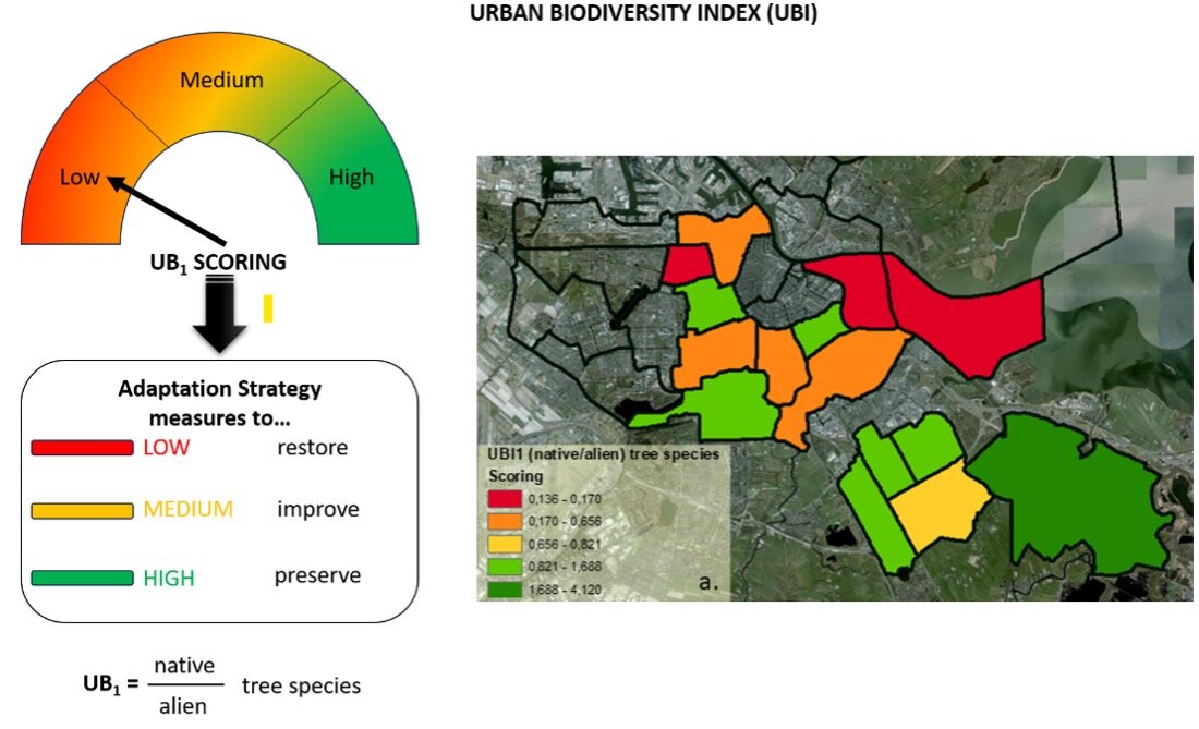
In the context of this project, the EEA is developing showcases on how openly available in situ datasets could be used to benefit climate adaptation policies and initiatives. For example, we developed a methodology making use of in situ data from city tree inventories to calculate indicators of Urban Biodiversity at the local level, automatising the tree species classification into native, invasive and toxic. This methodology will be made openly available, allowing other cities to import their own data and compute their version of this indicator, thus facilitating comparison across cities and over time (see above). We are also developing a methodology combining Earth Observation, statistical data and models of energy use at building level to derive a Building Energy Performance Indicator at district level.
Stefan JENSEN Acting Head of Programme Data and Information Services European Environment Agency
Earth Observation-based services are essential for tackling today’s major societal and environmental challenges. Space technologies are an indispensable tool in the fight against climate change, environmental degradation, and food insecurity. The European Commission and the African Union Commission are committed to working together to ensure that the GMES and Africa programme continues to be a reference in Africa for decision-makers and for a sustainable livelihood. This will not only be beneficial for the AfriGEO community, but it will surely contribute to the advancement of the GEO Work programme and its priorities.
Tidiane Ouattara Space Science expert and GMES & Africa Program Coordinator
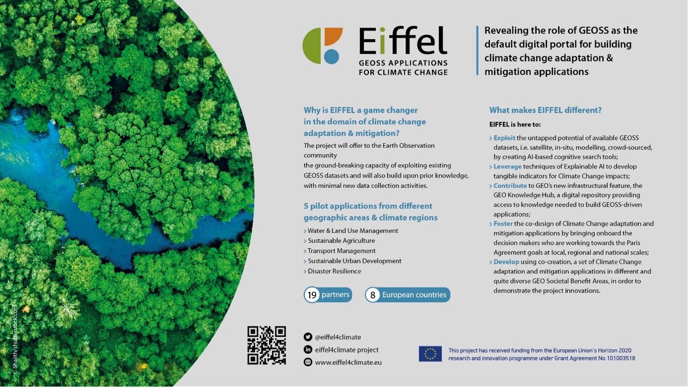
EIFFEL is an EU-funded Horizon 2020 project that aims to offer the EO-based community the ground-breaking capacity of exploiting existing GEOSS and external datasets and build upon prior knowledge, with minimal new data collection activities.
The project, aiming to address the GEO Societal Benefit Areas (Water and Land Use Management, Sustainable Agriculture, Transport Management, Sustainable Urban Development, Disaster Resilience) will uptake five pilot applications representing different geographic areas and climate regions, namely: i) Pilot 1: Water & Land-Use Management Regional Scale & Cross-border I Netherlands, Germany, ii) Pilot 2: Sustainable Agriculture National scale I Lithuania, iii) Pilot 3: Infrastructure & Transport Management Regional Scale I Spain, iv) Pilot 4: Sustainable Urban Development Local Regional Scale I Greece, v) Pilot 5: Disaster Resilience > Drought, forest fire & pest risk assessment Regional | National Scale Ι Finland. Moreover, EIFFEL actively participating in the GEO Work Programme post-2019, encourages the stakeholders’ engagement and involvement in the project activities. It also serves as a portal where other projects and initiatives can contribute offering their data for climate change.
EIFFEL project contributes to the new EuroGEO pilot applications to better understand Climate Change impacts, minimise the degradation of the Earth system, support accountability to long-term goals, inform climate services and decision making.
Dr. Angelos Amditis Research and Development Director, Institute of Communication and Computer Systems (ICCS) I Coordinator of EIFFEL project
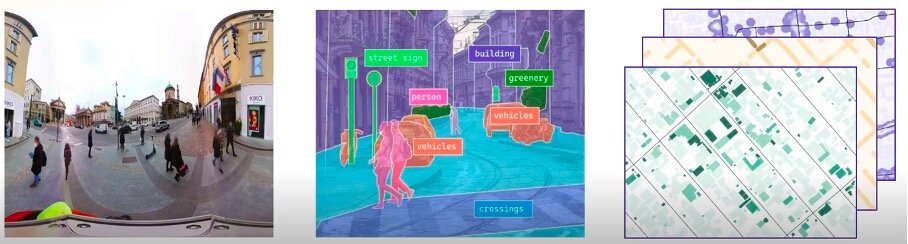
Citizen observatories to complement official measurements in the urban environment. The GREENGAGE project, funded by the European Commission’s Horizon Europe program, demonstrates the power of collaborative engagement: Focusing on mobility, air quality, and healthy living, citizens are encouraged to observe and actively participate in shaping their cities by mapping their urban environment to complement, validate, and enrich the information contained in authoritative data from public administrations and agencies. By involving citizens through Citizen Observatories and providing them with cutting-edge digital tools, GREENGAGE facilitates the co-creation of ground-level environmental monitoring solutions. This approach aligns seamlessly with GEO's mission of fostering cooperation between citizens, technical experts, and the scientific community to harness the full potential of climate-related products and services. GREENGAGE's dedication to innovative governance processes underscores its significant impact within the GEO community.
Jan Peters-Anders Coordinator of GREENGAGE and Research Engineer at AIT – Austrian Institute of Technology GmbH, Vienna
HARMONIA project supports the concept of Earth Intelligence: the HARMONIA Integrated Resilience Assessment Platform (IRAP) and Decision Support Systems (DSSs) are aimed at supporting decision-making and planning processes with knowledge derived by the integration of EO, in-situ and social data. The service provided is tailored for the needs of local administrations and takes into account the priorities and perceptions expressed by citizens in order to promote a collaborative approach for the improvement of urban resilience.
Prof. Julia Nerantzia TZORTZI Associate Professor, Ph. D. Coordinator of Harmonia (harmonia-project.eu) Politecnico di Milano
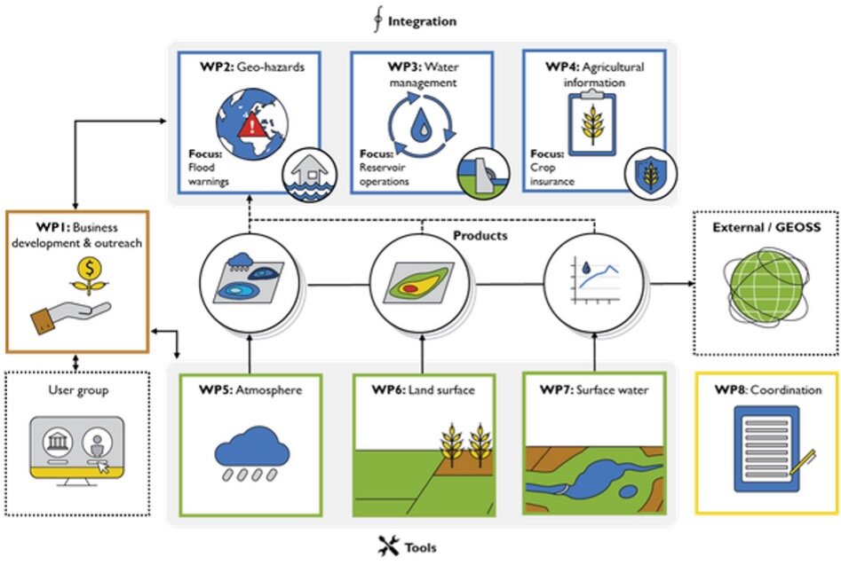
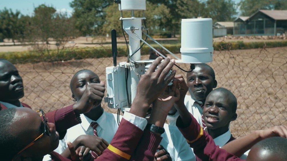
The TEMBO Africa project, supported by the European Commission’s Horizon Europe programme, develops services for Africa based on in situ data for flood early warning, hydropower dam reservoir management and agricultural germination insurance, starting in Kenya, Zambia and Ghana. TEMBO Africa also develops cost-effective new sensors for weather, water and climate applications in Africa. The income derived from the services will make it possible to make the weather, water and climate data of TEMBO Africa partner TAHMO open and freely available through GEOSS. TEMBO Africa supports the GEO in situ data working subgroup and is connected to the GEO Global Water Sustainability (GEOGLoWS) initiative.
Mark Noort CEO HCP International, GEOS Liaison TEMBO Africa Project
GEO Week 2022
31 Oct 22 - 04 Nov 22Accra, Ghana
Full Statement 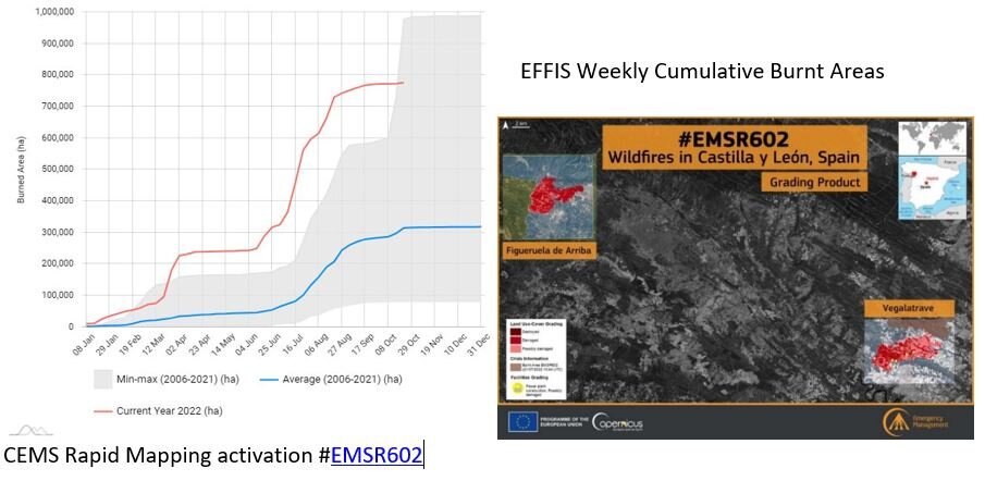
The Copernicus Emergency Management Service provided constant support during one of the worst wildfire season of the last decades that hit Europe in the Summer 2022. In the months of July and August, many records have been broken, in terms of number Rapid Mapping activations in a short lapse of time, but also in terms of intensity and consequential damages.
Mauro FACCHINI Head of Earth Observation Unit Directorate General for Defense Industry and Space European Commission
Since January 2021, thanks to the support of the European Commission, the European Environment Agency (EEA) is running a three-year project focused on improving the sharing and use of in situ Earth observation data in support of environment and climate policies. An important focus of this project lies on supporting the activities carried out by the GEO Data Working Group (DWG), in particular on in-situ data. Under the co-leadership of EEA, the In Situ Subgroup of the DWG is engaging with GEO Work Programme activities, identifying common barriers to in-situ data sharing and use and proposing ways to address these barriers. We are setting up a tool for the GEO community that will facilitate the systematic collection of in situ data requirements, following the successful model of CIS2 (Copernicus In Situ Component Information System). In close collaboration with GEO Work Programme activities, we will reach out to existing in-situ networks that are best placed to provide access to required data. We expect that these activities will improve the availability and accessibility of in-situ data, in line with the In Situ Data Strategy for GEO
Chris STEENMANS Head of Programme Data and Information Services European Environment Agency
The AFRICULTURES GEO community activity, with funding from the European Commission’s H2020 programme, has developed a digital platform on remote sensing services for food security in Africa, with special attention for climate, crops, drought, land, livestock, water and weather. Practical applications are developed to improve agricultural policy and extension services on irrigation support and food security early warning (Tunisia), regional pastoral information (Niger), early warning based on crop monitoring (Ghana), drought information for livestock farmers (South Africa), crop monitoring and yield forecasting (Mozambique), crop and crop condition mapping and water quality (Kenya) and crop monitoring and yield forecasting for national index insurance (Rwanda). AfriCultuReS contributes to the GEO Global Water Sustainability initiative (GEOGLoWS). AfriCultuReS will continue in the form of national and regional partnerships.
Juan Suarez Beltran Business Development Manager GMV AEROSPACE AND DEFENCE SA, Spain
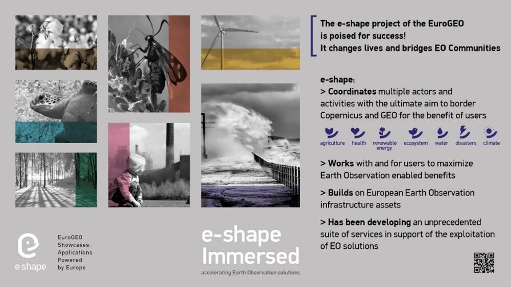
e-shape is a unique initiative under the EU-funded Horizon 2020 programme started in May 2019 that seeks to accelerate a breakthrough in the European Observation sector and serving GEO through further shaping the EuroGEO initiative. e-shape develops and promotes European EO capabilities with and for the users through a co-design approach with as a key element to bring new partners on-board”
e-shape supports the Canberra declaration by involving the private sector in the development of operational 37 pilots (27 original pilots and 10 on-boarded), and developed strategic activities to support GEO and EuroGEO. The 37 pilots developed by the project are discoverable from the GEO portal and contribute to a series of GEO activities in the current WP.
Amongst other key results such as the development of a Data Management Self-Assessment Tool allowing to assess GEO principles and FAIR principles for all GEO activities, the co-design methodology developed within e-shape will support the preparation of the post-2025 GEO Work programme through the set-up and evaluation of an incubator/integration approach inspired from the project. Guidebooks will be made available soon to the GEO and EuroGEO communities on Implementation of operational services and Capacity building. The sustainability booster developed within the project will support the EO-based products and services towards sustainability.
e-shape has also explored the future governance of EuroGEO and will share its views with the European Caucus at the next EuroGEO workshop to be held from 7 to 9 December 2022 in Athens, Greece.
Prof. Thierry Ranchin Director of Centre Observation, Impacts, Energy, MINES Paris – PSL /ARMINES Scientific coordinator of e-shape
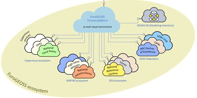
The European Commission has taken the initial steps towards the design and prototyping of EuroGEOSS - a virtual digital ecosystem, with the objective to show how wide range of European and National capacities and products can be interconnected. The objective of this investigation is to validate what a fully scaled up digital ecosystem could look like. It is conceived as an ecosystem for the GEO community, enabling its main stakeholders –whether policy makers, scientist, or businesses– to build value-added solutions based on Earth Observation data assets and services. A user centric approach will be adopted in the design and implementation of the prototypical virtual ecosystem, following recommendations highlighted in the Mid-Term Evaluation (MTE) report of the GEO Strategic Plan. In line with this, the initial steps undertaken have focused on the identification of community members' needs in terms of products, services and functionality, and translating these into technical requirements to be addressed by the future EuroGEOSS.
Josep SOLER GARRIDO Team Leader Joint Research Centre European Commission
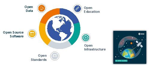
Advancing the understanding and adoption of open innovation approaches in Geospatial and Earth Observation is a key objective to enable impactful research addressing grand societal challenges. In 2022, the International Society for Photogrammetry and Remote Sensing (ISPRS) has established a Working Group acting at the interface between ISPRS Technical Commissions on Spatial Information Science, Remote Sensing and Education and Outreach. The WG, led by representatives of the European Commission and the European Space Agency, will establish strategic partnerships with key organisations in the Earth Observation domain, including GEO and its European counterpart EuroGEO in particular. Aligned with European approaches, the WG will advance knowledge in the investigation of technological, social, organisational and legal enablers and barriers for the development of open approaches in the Geospatial and Earth Observation domains, pertaining to open data, open source software, open standards, open education and research, across the dimensions of accessibility, inclusiveness and reproducibility.”
Anca ANGHELEA Open Science Platform Engineer, Science, Applications & Climate Department Directorate of EO Programmes, European Space Agency
The TWIGA project, supported by the European Commission’s H2020 programme, developed services for Africa based on in situ data for irrigation, crop management, weather information for small farmers, agricultural index insurance, flood early warning, dam reservoir management, cross-border water management, livestock heat stress, and solar energy, starting in Ghana, Kenya, Uganda, Mozambique and South Africa. TWIGA delivered in situ datasets on weather, GNSS, and soil moisture to GEOSS. New sensors were developed for weather, water and climate applications that are considerably cheaper than the current ones. For its water-related components TWIGA is part of the GEO Global Water Sustainability (GEOGLoWS) initiative. TWIGA partners and other parties will continue to expand the use of the services across Africa, making use of the TWIGA portal.
Nick Van de Giesen Technical University Delft
Resilient coastal cities are one of the big challenges for urban sustainability. But moving from resilience theory to practical implementation will require resilience strategies involving all the stakeholders. The GEO Citizen Science Initiative could fill the gap to elevate the value of citizen science communities and data from local to global scales. The ongoing projects to integrate citizen observations in pan-European infrastructures, such as Cos4Cloud that connects Citizen Observatories with the European Open Science Cloud -EOSC-, can facilitate and increase the use of Citizen Science in GEO by supporting global coordination and collaboration within and beyond GEO
Jaume PIERA H2020 Cos4Cloud coordinator and researcher from the Institute of Marine Sciences (ICM-CSIC)