Be tsunami ready: Investing in real-time forecasting to turn Earth Intelligence into action
.jpeg)
After Japan’s devastating 2011 tsunami, which claimed more than 18,000 lives, I became committed to the idea that we should do everything possible to ensure people have better, real-time information in future disasters. That tragedy marked an important shift for tsunami science in Japan and around the world.
At Tohoku University, and through our university-based startup RTi-cast, we are working with UNESCO’s Intergovernmental Oceanographic Commission (IOC) to make this vision a reality. Together, we’re developing a real-time, impact-based tsunami forecasting system that transforms Earth observations into life-saving intelligence.
From warnings to impact forecasts
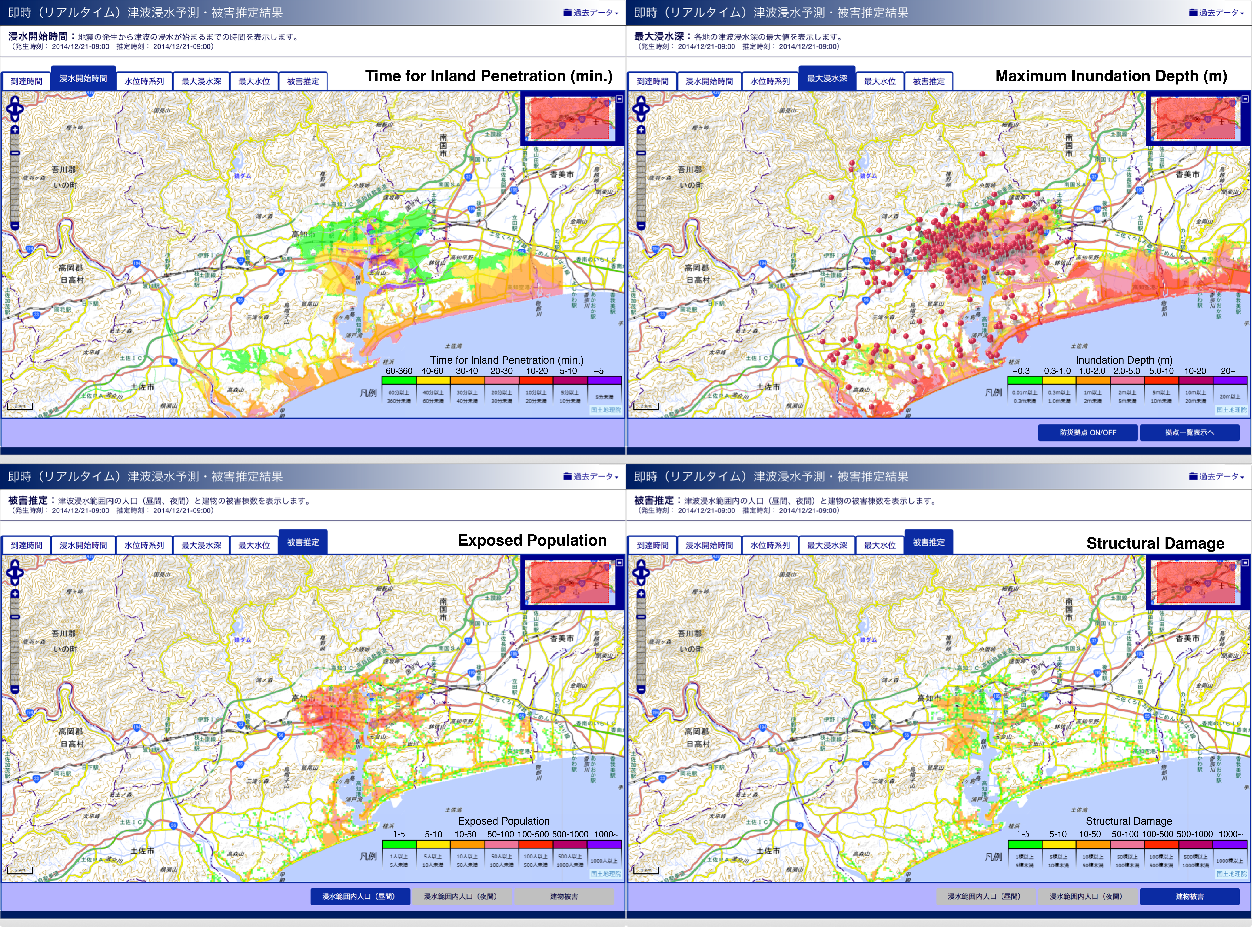
Traditional tsunami warnings estimate only the wave height at the coast. They don’t reveal what people on land most need to know, like how far the water will reach, how deep it will be and which areas will be flooded first.
Our approach uses Global Navigation Satellite System (GNSS) data – a form of Earth observations – to detect subtle crustal movements as earthquakes unfold. These signals allow us to reconstruct the rupture model of the seafloor within seconds and feed it into ultra-fast tsunami inundation simulations running on high-performance computers and GPU clusters.
Within four to six minutes, the system completes the simulations to produce detailed inundation maps showing inland penetration, flood depth, likely structural damage, and exposed populations. This is the kind of information emergency managers need most when deciding where to evacuate, when to dispatch first responders and how to coordinate recovery.
Scaling from Japan to the world
Since 2018, RTi-cast has provided nationwide tsunami forecasting for Japan’s Cabinet Office and local governments. Now, with support from Amazon Web Services, we’re taking the next step: creating a cloud-based global platform that any country can use.
By combining GNSS data, high-resolution topography, and local exposure information, this facility will deliver impact-based tsunami forecasts that directly support the UNESCO “Tsunami Ready” programme and Early Warnings for All.
Investing in preparedness means investing in Earth Intelligence
The theme of this year’s World Tsunami Awareness Day, “Be Tsunami Ready: Invest in Tsunami Preparedness,” reminds us that preparedness means knowledge. Investing in Earth intelligence like GNSS-based tsunami forecasting strengthens resilience, bridges the gap between science and practice and saves lives before disaster strikes.
Because when every second counts, smart use of Earth Intelligence can save lives.