Sweden
- Home/
- Partners/
- Member Governments/
- Sweden

Global Action for Local Impact is really something where GEO can contribute, and the continued work that GEO is doing in order to improve the availability, access and use of open Earth Observations is therefore of utmost importance. The development and implementation of the Work Programme 2023-2025 will be instrumental in providing better insights and evidence for policy development and decision making, which is expected to lead to improved local impact over time, not at least when it comes into the field of climate adaptation.

Global Action for Local Impact is required in order to accelerate the implantation of Agenda 2030, the Paris Agreement on Climate Change and the Sendai Framework for Disaster Risk Reduction. In this context, GEO has been contributing and will continue its efforts to improve the availability, access and use of open Earth Observations data. GEO Work Programme 2023–2025 will continue the work for enhanced delivery and impact of EOdata. Well received objectives of the Work Programme are the greater collaboration and integration of Programme activities, stronger emphasis on open knowledge and more specific identification of outputs and intended actual users.

Global Action for Local Impact is required in order to accelerate the implantation of Agenda 2030, the Paris Agreement on Climate Change and the Sendai Framework for Disaster Risk Reduction. In this context, GEO has been contributing and will continue its efforts to improve the availability, access and use of open Earth Observations data. GEO Work Programme 2023–2025 will continue the work for enhanced delivery and impact of EOdata. Well received objectives of the Work Programme are the greater collaboration and integration of Programme activities, stronger emphasis on open knowledge and more specific identification of outputs and intended actual users.
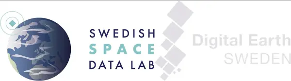
The Swedish Space Agency is together with Luleå Technical University, Research Institutes of Sweden and AI Sweden developing the Swedish Space Data Lab, to promote innovation, method development and promote the use of AI with Earth Observation data. The platform that is the Collaborative Ground Segment for Copernicus in Sweden is further developed to Digital Earth Sweden, to further enhance the Swedish capacity of processing and analyzing earth observation data. Digital Earth Sweden is based on the Open Data Cube and the OpenEO API. All developments are provided as Open Source as part of the capacity building effort of the lab.
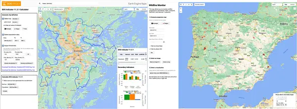
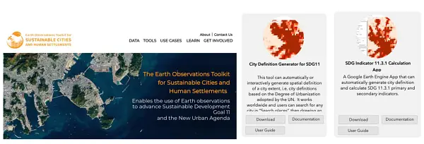
Using Earth Observations big data and AI, KTH Royal Institute of Technology has developed innovative methods and applications to support sustainable and resilient urban planning, and early detection and near real-time monitoring of wildfires. The EO-based wildfire applications developed by the KTH team can be used by fire-fighting authorities for effective emergency management and decision support during and after wildfires. The EO&AI-based method developed by KTH produced high-quality urban mapping and change detection results for 60 cities around the globe. Using EO-derived urban data in the EO4SDG11 Toolkit, KTH developed a Google Earth Engine app for automatic city definition and calculation of SDG 11.3.1 “Land Use Efficiency” core and secondary indicators for any city in the world. The SDG11.3.1 Land Use Efficiency app is nominated for the GEO SDG 2022 award. The research is part of the EO-AI4GlobalChange project, funded by the GEO-Google Earth Engine Program and the Digital Futures of Sweden, with close collaborations with stakeholders including the City of Stockholm, UN Habitat, Swedish Civil Contingencies Agency (MSB) and British Columbia Wildfire Services. As member of the EO4SDG Toolkit Steering Committee member at GEO, KTH has played an important role in the EO4SDG11 Toolkit development. Testimonial on the SDG11.3.1 app https://eo4sdg11.users.earthengine.app/view/sdg-1131-indicator Dennis Mwaniki, Spatial Data Expert, & Robert Ndugwa, Head, Data & Analytics Section UN-Habitat: The innovative tool not only provides an easy way to extract information from EO data and compute SDG 11.3.1 core and secondary indicators following the global indicator methodology (including adopting the harmonized DEGURBA methodology), but also gives the user the power to input their own data and adjust boundaries where inconsistencies and/or misclassification noted. This flexibility, and the simplicity with which the tool enables users to visualize and interact with the diverse archive of EO products makes it an invaluable resource that will significantly improve data production at the local level and enhance SDG 11.3.1 monitoring at the global scale. Testimonial on the Wildfire app https://omegazhangpzh.users.earthengine.app/view/wildfire-monitor-v7 Justin Nicholas, Wildfire Technician, British Columbia Wildfire Services: We are encouraged by the excellent data products and visualization tools produced (by KTH). Overall, we are very excited with the prospect of near-real time processing of multiple satellite dataset to compile reliable fire progression maps as quickly as possible and we are very impressed with the high quality of the products generated. This technology could have significant positive economic and societal impacts in British Columbia.
The Earth Talks through its triple planetary crisis of climate change, pollution and biodiversity loss. Earth observation data that are easy to access and understand can support the global agendas and help the decision-making processes. Europe will continue to be a major contributor to GEO through its Earth Observations program Copernicus and the new Destination Earth initiative, which aims to develop a very high precision digital model of the Earth to monitor and simulate natural and human activity.
The Earth Talks through its triple planetary crisis of climate change, pollution and biodiversity loss. Earth observation data that are easy to access and understand can support the global agendas and help the decision-making processes. Europe will continue to be a major contributor to GEO through its Earth Observations program Copernicus and the new Destination Earth initiative, which aims to develop a very high precision digital model of the Earth to monitor and simulate natural and human activity.

The Swedish Space Agency is, together with Luleå Technical University, Research Institutes of Sweden and AI Sweden, developing the Swedish Space Data Lab, to promote innovation, method development and the use of AI with Earth Observation data. The platform that is the Collaborative Ground Segment for Copernicus in Sweden is further developed to Digital Earth Sweden, to further enhance the Swedish capacity of processing and analyzing earth observation data. Digital Earth Sweden is a national innovation hub for Swedish authorities using earth observation data, and for the development of AI-based analysis of the data. The purpose of the lab is to enable increased use of data from space for the development of society for the benefit of the globe. The goal is to get data, technology, and methodology in place to enable systematic development of space-based data, services and applications. Space data is used in a wide range of fields. It is indispensable for, among other things, weather forecasts and monitoring the climate, but it is also extremely important for forestry, agriculture and other fields in which up-to-date information about vegetation and the land surface is needed.
Leveraging Earth Observation big data and AI, KTH Royal Institute of Technology has developed innovative methods for urban mapping and urbanization monitoring to support resilient and sustainable urban development, and for early detection and near real-time monitoring of wildfires to support effective emergency response and decision support. The novel unsupervised domain adaptation method developed by KTH can produce high-quality built-up maps and be deployed in any city around the world. Using EO-derived urban data, KTH also developed two Google Earth Engine applications that have been included in the GEO-UN Habitat’s EO4SDG11 Toolkit. The City Definition Generator for SDG11 APP can automatically generate spatial definition of a city extent that is essential for a number of SDG11 indicators. The SDG Indicator 11.3.1 Calculation App can automatically calculate SDG 11.3.1 “Land Use Efficiency” primary and secondary indicators for any city in the world. The SDG11.3.1 Land Use Efficiency app won the 2022 GEO SDG award (Academia) for KTH. KTH also contributed to the UN Habitat’s SDG 11 Synthesis Report to the 2023 UN High Level Political Forum on “Rescuing SDG 11 for a Resilient Urban Planet”. The EO&AI-powered approaches developed by KTH have been tested for early detection and near real-time monitoring of wildfires in numerous sites around the world. The more reliable insights on wildfires not only can enhance emergency response but also improve the estimation of environmental impact of wildfires including biomass loss and CO/CO2 emission. The impactful research has led KTH to be nominated for the Google Geo for Good 2023 Impact Award.
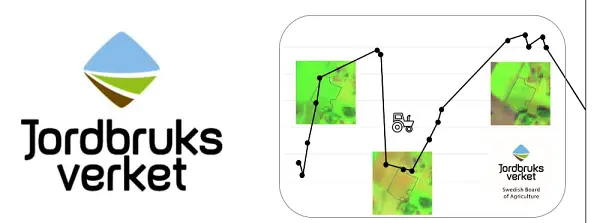
In 2023, the Swedish Board of Agricultural launched an automatic system that follows up activities for all agricultural land in Sweden using Copernicus Sentinel data and geotagged photos. The purpose of the follow-up is to ensure that we pay support to those farmers who manage their land in the correct way. An important part of this is to give farmers a chance to correct their applications of aid to agree with reality, to avoid deductions from the support. In the long run, the follow-up also leads to fewer on the spot controls which will reduce the administrative burden of the agency. Following up agricultural land with satellite images is a requirement that the European Commission places on all member states. The system is intended to be continuously developed over the coming years.