
Germany
- Home/
- Partners/
- Member Governments/
- Germany

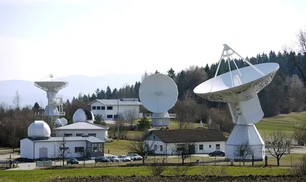
The Global Geodetic Centre of Excellence (GGCE) will be formally established at the UN-Campus in Bonn/Germany by the end of 2022 and start to operate in early 2023. Its establishment has been decided by UN-GGIM back in 2020. With the GGCE, Germany supports the establishment of a sustainable globally coordinated geodetic infrastructure as a basis for Earth Observations and Navigation applications. It allows, for instance, more efficient and accurate monitoring of sea level or earth crust changes. The GGCE will in particular support developing countries and foster open exchange of geodetic data. The Federal Agency for Cartography and Geodesy (BKG) is an international geodetic reference as operator of geodetic observatories on three continents and will support the work of the GGCE with its expertise. Germany will – through its Federal Agency for Cartography and Geodesy (BKG) –contribute to the success of the GGCE by providing the necessary financial means to establish and start the GGCE.
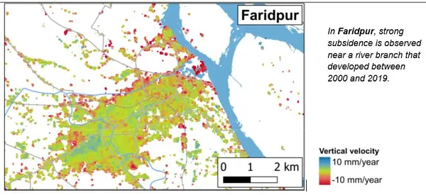
The Federal Institute for Geosciences and Natural Resources (BGR) carries out several development cooperation projects with African, Latin American and Asian partner countries. Many different, mainly freely available satellite data, digital elevation models and geological survey data are used in these projects, e.g.: In cooperation with the Geological Survey of Bangladesh (GSB), the project “Geo-Information for Urban Planning and Adaptation to Climate Change” supports the planning agencies in the pilot cities of Kushtia, Faridpur, Satkhira, Barisal, Sirajganj and Khulna with remote sensing observations based on Copernicus Sentinel and Landsat data. Linking e.g. land-use with inundation data and river-course monitoring with InSAR-derived multi-temporal ground motion for the pilot city of Faridpur enables a comprehensive view on geo-hazards, building ground suitability and the underlying processes within a planning area. The project “Geothermal Energy in East Africa” includes cooperation with the Djiboutian project partner Office Djiboutien de Développement de l’Énergie Géothermique (ODDEG). The regional capacity for geothermal exploration in four countries of SICA ("Central America Integration System"), which acts as a political partner, is realized through activities in Costa Rica, Nicaragua, El Salvador, and Guatemala. Several remote sensing methods are applied to provide support for current geothermal exploration studies.
“The Environmental Mapping and Analysis Program (EnMAP) is a German hyperspectral satellite mission that aims at monitoring and characterizing Earth’s environment. EnMAP measures key dynamic processes of Earth’s terrestrial and aquatic ecosystems by extracting geochemical, biochemical and biophysical parameters. The mission was successfully launched in April 1st 2022. Routine operations has started on November 2, 2022. Data is now provided with a free and open data policy to the global scientific user community. To visualize and process imaging spectroscopy data the EnMAP Toolbox was developed and is provided freely to the community. And with the online learning initiative HYPERedu hosted on the EO-College Platform, we support the GEO community in practicing the use of imaging spectroscopy for local environmental challenges and global cooperation. Further information on the mission, news and announcements of opportunities are available on https://www.enmap.org/.”

The Global Geodetic Centre of Excellence (GGCE) started to operate at the UN-Campus in Bonn/Germany in early 2023. The GGCE is going to provide important contributions to a worldwide geodetic infrastructure which is the reliable long-term foundation for applications like satellite navigation, space-borne Earth observation, and the monitoring of the UN Sustainable Development Goals. The Federal Agency for Cartography and Geodesy (BKG) is an international geodetic reference as operator of geodetic observatories on three continents and will support the work of the GGCE with its expertise. Germany – through BKG – contributes to the success of the GGCE by providing the necessary financial means to establish and start the GGCE.

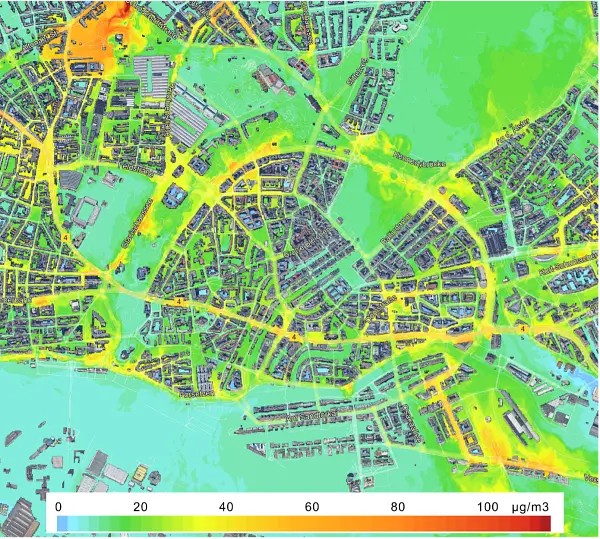
Global urban development and health risks from climate change and air pollution can be assessed using the services ‘World Settlement Footprint’ and ‘Atmospheric Composition Monitoring’ as provided by DLR’s Earth Observation Center (https://geoservice.dlr.de/web/). To develop healthy and climate-resilient cities and assess the urban environment under current and future climate conditions and mobility scenarios these satellite products need to be combined with Urban Climate Models, like PALM-4U. As a contribution to EuroGEO, DLR developed services on “Urban Health Risks from Air Pollution” (https://www.alpendac.eu/eshape) and “Urban Climate Under Change. Given the demand for integrated assessments of multiple urban health risks, the development of user-driven services is essential. By following a rigorous co-design process, we look forward to contributing to GEO and strive for a continued uptake in science, planning and economy.
The Federal Institute for Geosciences and Natural Resources (BGR) carries out several development cooperation projects with African, Latin American and Asian partner countries. Many different, mainly freely available satellite data (e.g. Copernicus, Landsat), digital elevation models and geological survey data are used in these projects. The cooperation project with the Geological Survey of Bangladesh (GSB) “Geo-Information for Urban Planning and Adaptation to Climate Change” supporting the planning agencies in pilot cities data was successfully completed concerning the EO data aspect. The regional capacity enhancement for geothermal exploration in four countries of SICA (Central America Integration System) is currently being continued in the form of intensified training and application workshops.

