European Commission
- Home/
- Partners/
- Member Governments/
- European Commission


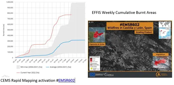
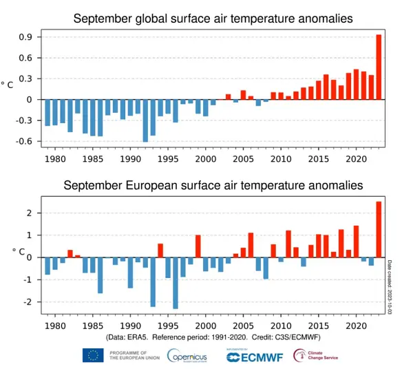
The Copernicus Emergency Management Service provided constant support during one of the worst wildfire season of the last decades that hit Europe in the Summer 2022. In the months of July and August, many records have been broken, in terms of number Rapid Mapping activations in a short lapse of time, but also in terms of intensity and consequential damages.
Since January 2021, thanks to the support of the European Commission, the European Environment Agency (EEA) is running a three-year project focused on improving the sharing and use of in situ Earth observation data in support of environment and climate policies. An important focus of this project lies on supporting the activities carried out by the GEO Data Working Group (DWG), in particular on in-situ data. Under the co-leadership of EEA, the In Situ Subgroup of the DWG is engaging with GEO Work Programme activities, identifying common barriers to in-situ data sharing and use and proposing ways to address these barriers. We are setting up a tool for the GEO community that will facilitate the systematic collection of in situ data requirements, following the successful model of CIS2 (Copernicus In Situ Component Information System). In close collaboration with GEO Work Programme activities, we will reach out to existing in-situ networks that are best placed to provide access to required data. We expect that these activities will improve the availability and accessibility of in-situ data, in line with the In Situ Data Strategy for GEO
The AFRICULTURES GEO community activity, with funding from the European Commission’s H2020 programme, has developed a digital platform on remote sensing services for food security in Africa, with special attention for climate, crops, drought, land, livestock, water and weather. Practical applications are developed to improve agricultural policy and extension services on irrigation support and food security early warning (Tunisia), regional pastoral information (Niger), early warning based on crop monitoring (Ghana), drought information for livestock farmers (South Africa), crop monitoring and yield forecasting (Mozambique), crop and crop condition mapping and water quality (Kenya) and crop monitoring and yield forecasting for national index insurance (Rwanda). AfriCultuReS contributes to the GEO Global Water Sustainability initiative (GEOGLoWS). AfriCultuReS will continue in the form of national and regional partnerships.
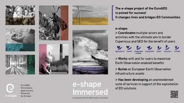
e-shape is a unique initiative under the EU-funded Horizon 2020 programme started in May 2019 that seeks to accelerate a breakthrough in the European Observation sector and serving GEO through further shaping the EuroGEO initiative. e-shape develops and promotes European EO capabilities with and for the users through a co-design approach with as a key element to bring new partners on-board” e-shape supports the Canberra declaration by involving the private sector in the development of operational 37 pilots (27 original pilots and 10 on-boarded), and developed strategic activities to support GEO and EuroGEO. The 37 pilots developed by the project are discoverable from the GEO portal and contribute to a series of GEO activities in the current WP. Amongst other key results such as the development of a Data Management Self-Assessment Tool allowing to assess GEO principles and FAIR principles for all GEO activities, the co-design methodology developed within e-shape will support the preparation of the post-2025 GEO Work programme through the set-up and evaluation of an incubator/integration approach inspired from the project. Guidebooks will be made available soon to the GEO and EuroGEO communities on Implementation of operational services and Capacity building. The sustainability booster developed within the project will support the EO-based products and services towards sustainability. e-shape has also explored the future governance of EuroGEO and will share its views with the European Caucus at the next EuroGEO workshop to be held from 7 to 9 December 2022 in Athens, Greece.
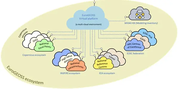
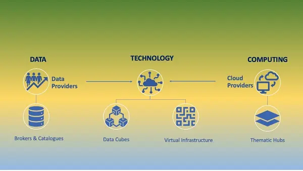
The European Commission has taken the initial steps towards the design and prototyping of EuroGEOSS - a virtual digital ecosystem, with the objective to show how wide range of European and National capacities and products can be interconnected. The objective of this investigation is to validate what a fully scaled up digital ecosystem could look like. It is conceived as an ecosystem for the GEO community, enabling its main stakeholders –whether policy makers, scientist, or businesses– to build value-added solutions based on Earth Observation data assets and services. A user centric approach will be adopted in the design and implementation of the prototypical virtual ecosystem, following recommendations highlighted in the Mid-Term Evaluation (MTE) report of the GEO Strategic Plan. In line with this, the initial steps undertaken have focused on the identification of community members' needs in terms of products, services and functionality, and translating these into technical requirements to be addressed by the future EuroGEOSS.
The European Commission has taken the initial steps towards the design and prototyping of EuroGEOSS - a virtual digital ecosystem, with the objective to show how wide range of European and National capacities and products can be interconnected. The objective of this investigation is to validate what a fully scaled up digital ecosystem could look like. It is conceived as an ecosystem for the GEO community, enabling its main stakeholders –whether policy makers, scientist, or businesses– to build value-added solutions based on Earth Observation data assets and services. A user centric approach will be adopted in the design and implementation of the prototypical virtual ecosystem, following recommendations highlighted in the Mid-Term Evaluation (MTE) report of the GEO Strategic Plan. In line with this, the initial steps undertaken have focused on the identification of community members' needs in terms of products, services and functionality, and translating these into technical requirements to be addressed by the future EuroGEOSS.
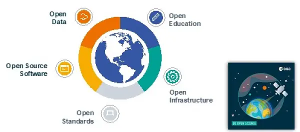
Advancing the understanding and adoption of open innovation approaches in Geospatial and Earth Observation is a key objective to enable impactful research addressing grand societal challenges. In 2022, the International Society for Photogrammetry and Remote Sensing (ISPRS) has established a Working Group acting at the interface between ISPRS Technical Commissions on Spatial Information Science, Remote Sensing and Education and Outreach. The WG, led by representatives of the European Commission and the European Space Agency, will establish strategic partnerships with key organisations in the Earth Observation domain, including GEO and its European counterpart EuroGEO in particular. Aligned with European approaches, the WG will advance knowledge in the investigation of technological, social, organisational and legal enablers and barriers for the development of open approaches in the Geospatial and Earth Observation domains, pertaining to open data, open source software, open standards, open education and research, across the dimensions of accessibility, inclusiveness and reproducibility.”
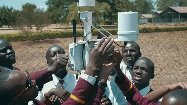
The TWIGA project, supported by the European Commission’s H2020 programme, developed services for Africa based on in situ data for irrigation, crop management, weather information for small farmers, agricultural index insurance, flood early warning, dam reservoir management, cross-border water management, livestock heat stress, and solar energy, starting in Ghana, Kenya, Uganda, Mozambique and South Africa. TWIGA delivered in situ datasets on weather, GNSS, and soil moisture to GEOSS. New sensors were developed for weather, water and climate applications that are considerably cheaper than the current ones. For its water-related components TWIGA is part of the GEO Global Water Sustainability (GEOGLoWS) initiative. TWIGA partners and other parties will continue to expand the use of the services across Africa, making use of the TWIGA portal.
Resilient coastal cities are one of the big challenges for urban sustainability. But moving from resilience theory to practical implementation will require resilience strategies involving all the stakeholders. The GEO Citizen Science Initiative could fill the gap to elevate the value of citizen science communities and data from local to global scales. The ongoing projects to integrate citizen observations in pan-European infrastructures, such as Cos4Cloud that connects Citizen Observatories with the European Open Science Cloud -EOSC-, can facilitate and increase the use of Citizen Science in GEO by supporting global coordination and collaboration within and beyond GEO
The Group on Earth Observations (GEO) is working closely with Copernicus, the Earth observation component of the European Union (EU)’s Space Programme, as well as Horizon Europe, EU’s Research and Innovation Programme, to bring together global Earth observation and other data in support of Sustainable Development Goals, Climate Action, Disaster Risk Reduction and broader policy and decision making in a wide range of sectors. From the start, Copernicus was conceived, designed, and implemented as the EU contribution to GEO with similar free and open data policy principles. As an example, ‘maps without gaps’ developed by the Copernicus Climate Change Service (C3S) use a wealth of observations from those many data streams and allow tracking climate variability and change over time in a consistent way so as to support EU’s climate mitigation and adaptation strategies.
In a data driven economy, earth observation data and services are a game changer and essential input in building sustainable Early Warning Systems for effective climate change adaptation and disaster risk reduction. The European Commission committed to support the strengthening of Africa Multi-Hazard Early Warning and Early Action System (AMEWHAS), ultimately contributing also to the GEO work programme priorities on Disaster Risk Reduction.
Earth Observation (EO) digital cloud infrastructures have emerged as easily accessible environments with the essential assets and processing tools required for analyzing data in a highly automated and scalable way. However, the current EO infrastructures and initiatives landscape is fragmented, with different levels of user onboarding and uptake success. The Joint Research Centre (JRC), the European Commission's science and knowledge service, is mapping the user’s requirements to existing EO infrastructures and services, with the goal of identifying existing overlaps and gaps. The JRC reviewed over 150 digital infrastructures and initiatives and categorized them according to the most prominent services. From a user-driven perspective, a series of requirements spanning from discoverability of available datasets, models, services, to transparency of pricing, from the problem of service sustainability to service redundancy, transparency of costs and technical specs, interoperability and accessibility, were investigated. The outcome is a preliminary phase for designing a user centric framework in evaluating EO digital infrastructures. To complement the work, also a series of advisory technological enablers are provided in order to alleviate user’s challenges and enhance interconnection amongst the services, thus facilitating the interoperability between platforms and fostering the discoverability of available services.
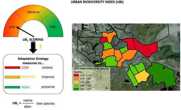
In support of the European Commission, the European Environment Agency (EEA) has been running a three-year project focused on improving the sharing and use of in situ Earth observation data in support of environment and climate policies. An important focus of this project lies in supporting the GEO Data Working Group (DWG), in particular its in-situ data activities. Under the co-leadership of EEA, the In Situ Subgroup of the DWG is engaging with GEO Work Programme activities, identifying common barriers to in-situ data sharing and use and proposing ways to address these barriers. We have developed a tool for the GEO community (G-reqs) that provides a methodology for the collection and management of in-situ data user requirements, and we are currently engaging GEO Work Programme activities to document their needs. We expect that these activities will be improve the availability and accessibility of in-situ data, in line with the In Situ Data Strategy for GEO. In the context of this project, the EEA is developing showcases on how openly available in situ datasets could be used to benefit climate adaptation policies and initiatives. For example, we developed a methodology making use of in situ data from city tree inventories to calculate indicators of Urban Biodiversity at the local level, automatising the tree species classification into native, invasive and toxic. This methodology will be made openly available, allowing other cities to import their own data and compute their version of this indicator, thus facilitating comparison across cities and over time (see above). We are also developing a methodology combining Earth Observation, statistical data and models of energy use at building level to derive a Building Energy Performance Indicator at district level.
Earth Observation-based services are essential for tackling today’s major societal and environmental challenges. Space technologies are an indispensable tool in the fight against climate change, environmental degradation, and food insecurity. The European Commission and the African Union Commission are committed to working together to ensure that the GMES and Africa programme continues to be a reference in Africa for decision-makers and for a sustainable livelihood. This will not only be beneficial for the AfriGEO community, but it will surely contribute to the advancement of the GEO Work programme and its priorities.
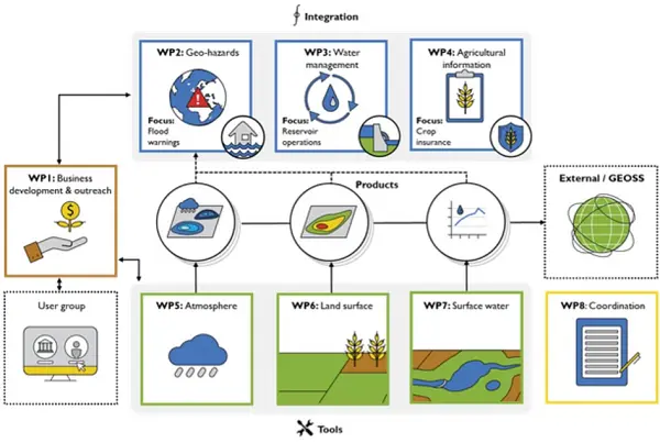
EIFFEL is an EU-funded Horizon 2020 project that aims to offer the EO-based community the ground-breaking capacity of exploiting existing GEOSS and external datasets and build upon prior knowledge, with minimal new data collection activities. The project, aiming to address the GEO Societal Benefit Areas (Water and Land Use Management, Sustainable Agriculture, Transport Management, Sustainable Urban Development, Disaster Resilience) will uptake five pilot applications representing different geographic areas and climate regions, namely: i) Pilot 1: Water & Land-Use Management Regional Scale & Cross-border I Netherlands, Germany, ii) Pilot 2: Sustainable Agriculture National scale I Lithuania, iii) Pilot 3: Infrastructure & Transport Management Regional Scale I Spain, iv) Pilot 4: Sustainable Urban Development Local Regional Scale I Greece, v) Pilot 5: Disaster Resilience > Drought, forest fire & pest risk assessment Regional | National Scale Ι Finland. Moreover, EIFFEL actively participating in the GEO Work Programme post-2019, encourages the stakeholders’ engagement and involvement in the project activities. It also serves as a portal where other projects and initiatives can contribute offering their data for climate change. EIFFEL project contributes to the new EuroGEO pilot applications to better understand Climate Change impacts, minimise the degradation of the Earth system, support accountability to long-term goals, inform climate services and decision making.

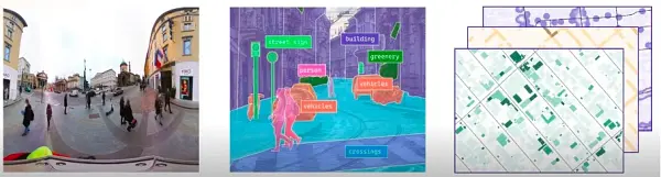
Citizen observatories to complement official measurements in the urban environment. The GREENGAGE project, funded by the European Commission’s Horizon Europe program, demonstrates the power of collaborative engagement: Focusing on mobility, air quality, and healthy living, citizens are encouraged to observe and actively participate in shaping their cities by mapping their urban environment to complement, validate, and enrich the information contained in authoritative data from public administrations and agencies. By involving citizens through Citizen Observatories and providing them with cutting-edge digital tools, GREENGAGE facilitates the co-creation of ground-level environmental monitoring solutions. This approach aligns seamlessly with GEO's mission of fostering cooperation between citizens, technical experts, and the scientific community to harness the full potential of climate-related products and services. GREENGAGE's dedication to innovative governance processes underscores its significant impact within the GEO community.
HARMONIA project supports the concept of Earth Intelligence: the HARMONIA Integrated Resilience Assessment Platform (IRAP) and Decision Support Systems (DSSs) are aimed at supporting decision-making and planning processes with knowledge derived by the integration of EO, in-situ and social data. The service provided is tailored for the needs of local administrations and takes into account the priorities and perceptions expressed by citizens in order to promote a collaborative approach for the improvement of urban resilience.
The TEMBO Africa project, supported by the European Commission’s Horizon Europe programme, develops services for Africa based on in situ data for flood early warning, hydropower dam reservoir management and agricultural germination insurance, starting in Kenya, Zambia and Ghana. TEMBO Africa also develops cost-effective new sensors for weather, water and climate applications in Africa. The income derived from the services will make it possible to make the weather, water and climate data of TEMBO Africa partner TAHMO open and freely available through GEOSS. TEMBO Africa supports the GEO in situ data working subgroup and is connected to the GEO Global Water Sustainability (GEOGLoWS) initiative.